
Following the launch of trove.scot in February 2025 we are now planning the retiral of some of our webservices. Canmore will be switched off on 24th June 2025. Information about the closure can be found on the HES website: Retiral of HES web services | Historic Environment Scotland
St Kilda, Hirta, An Lag Bho'n Tuath


Cleit(S) (Post Medieval), Mound(S) (Post Medieval), Peat Stand(S) (Post Medieval)
Site Name St Kilda, Hirta, An Lag Bho'n Tuath
Classification Cleit(S) (Post Medieval), Mound(S) (Post Medieval), Peat Stand(S) (Post Medieval)
Canmore ID 9664
Site Number NF19NW 18
NGR NF 1027 9955
NGR Description from NF 10100 99656 to NF 10466 99635
Datum OSGB36 - NGR
Permalink http://canmore.org.uk/site/9664


- Council Western Isles
- Parish Harris
- Former Region Western Isles Islands Area
- Former District Western Isles
- Former County Inverness-shire
NF19NW 18 1028 9956.
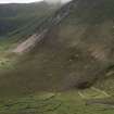
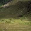
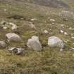
Centred NF 1028 9956. In the hollow An Lag Bho'n Tuath, and mainly situated on the moraine that fronts it, are a number of curious mounds, which on examination could well be burial cairns. Of the 17 noted, at least three exhibit a 'boat-shaped' setting of slabs with their long axis orientated NNE-SSW - facing the Bay. These structures measure some 3 x 1.0m (at the widest point) although one seems to extend to c.5.5m The pointed end is at the S. The stony mounds in which these structures are contained, are sometimes pear-shaped measuring c.4.5 x 3.0m and 0.2-0.3m high. Others are elongated, and some almost circular (c.4.0m in diameter).
One interesting specimen - NF 1030 9964 - c.6.8m in diameter and 0.3m high, is situated on an excavated platform bounded by a course of stones, possibly the remnants of a bank. A slightly hollowed berm 2.5m wide separates the cairn from the platform edge on the SE. Only a few stones mark the course of the perimeter on the NW, or uphill side.
What may be the site of another similar feature lies c.50.0m to the SW; but only a slight platform, and very little stone, remains. The mound and grave at 1032 9959 is also on a slight platform.
A cairn at 1025 9961, 4.0m in diameter contains what may be a cist - a setting of slabs on end measuring 1.4 x 0.8m wide at one end and 0.2m at the other.
It should perhaps be considered, without excavation, that some of these 'cairns' may well be the remains of old cleits, long since replaced by others; but the 'boat-shaped' structures could well be Viking graves, and the discovery of Viking grave goods on the island could well substantiate this.
Visited by OS (J L D) 11 August 1967.
Field Visit (11 August 1967)
Centred NF 1028 9956. In the hollow An Lag Bho'n Tuath, and mainly situated on the moraine that fronts it, are a number of curious mounds, which on examination could well be burial cairns. Of the 17 noted, at least three exhibit a 'boat-shaped' setting of slabs with their long axis orientated NNE-SSW - facing the Bay. These structures measure some 3 x 1.0m (at the widest point) although one seems to extend to c.5.5m The pointed end is at the S. The stony mounds in which these structures are contained, are sometimes pear-shaped measuring c.4.5 x 3.0m and 0.2-0.3m high. Others are elongated, and some almost circular (c.4.0m in diameter).
One interesting specimen - NF 1030 9964 - c.6.8m in diameter and 0.3m high, is situated on an excavated platform bounded by a course of stones, possibly the remnants of a bank. A slightly hollowed berm 2.5m wide separates the cairn from the platform edge on the SE. Only a few stones mark the course of the perimeter on the NW, or uphill side.
What may be the site of another similar feature lies c.50.0m to the SW; but only a slight platform, and very little stone, remains. The mound and grave at 1032 9959 is also on a slight platform.
A cairn at 1025 9961, 4.0m in diameter contains what may be a cist - a setting of slabs on end measuring 1.4 x 0.8m wide at one end and 0.2m at the other.
It should perhaps be considered, without excavation, that some of these 'cairns' may well be the remains of old cleits, long since replaced by others; but the 'boat-shaped' structures could well be Viking graves, and the discovery of Viking grave goods on the island could well substantiate this.
Visited by OS (J L D) 11 August 1967.
Plan and section at 1:1250
Field Visit (3 September 2008)
This group extends from NF 10100 99656 to NF 10466 99635 (from Hirta 993 in the W to Hirta 1001 in the E) and from NF 10267 99745 to NF 10327 99468 (from Hirta 1016 in the N to Hirta 998 in the S). It comprises forty nine cleits, six peat stands and two mounds, both of which may also be the remains of collapsed cleits. The group stretches across the relatively flat ground above the Village Bay head dyke to the NW of the Dry Burn and onto the lower slopes of Conachair. Much of the flat ground has been stripped back to bedrock and here the cleits have been heavily robbed, remaining as little more than footings. The cleits on the lower slopes of Conachair are better preserved, most retaining some if not all of their roof lintels, many too with fragments of their turf caps.
(Hirta 993-1016, 2016-39, 2177, 2180, 2211, 2215, 2231, 2252, 2280-2)
Visited by RCAHMS (ARG,SPH) 3 September 2008
Change Of Classification (29 March 2010)
Classification amended from Cairns and Peat Stands to Cleits, Peat Stands and Mounds. At the same time, the NGR was upgraded from NF 1028 9956 to NF 10278 99637 and is now centred on a cleit (Hirta 1009).
(Hirta 993-1016, 2016-39, 2231)
Information from RCAHMS (ARG) 29 March 2010

