
RCAHMS Archaeological Survey: St Kilda


Date 2007 - 2011
Event ID 580629
Category Project
Type Project
Permalink http://canmore.org.uk/event/580629
From 2007 to 2011, a team of archaeologists and surveyors from RCAHMS and the National Trust for Scotland (NTS) mapped the archaeological remains on Hirta and the other islands in the St Kilda archipelago. The project was led by RCAHMS surveyor Ian G Parker and archaeologist Angela R Gannon, with contributions from many other RCAHMS and NTS staff, in particular NTS archaeologist Jill Harden. The team used Global Positioning System survey equipment and ortho-rectified aerial photography to map the islands’ archaeological features at a scale of 1:5000. This is available as a digital linework dataset (TM 000078); also available is a database of all the cleitean (DT 000117), which uses the numbering sequence developed in the 1980s by Mary Harman. Summary descriptions for the all the groups of cleitean are available in Canmore. The survey referenced previous work undertaken by RCAHMS and Mary Harman, as well as more recent surveys undertaken by GUARD, the NTS volunteers and Andrew Fleming. To complement the 1985 RCAHMS plane table survey of the eastern side of Gleann Mor, additional 1:500 site plans (derived from both aerial photography and field observation) were created for sites in the NE and W sectors. RCAHMS photographer Steve Wallace supported the team in May 2008, producing digital images of the landscape as well as general and detailed views of the buildings and archaeological features.
Access to the outer islands was difficult: Dun and Boreray were visited in 2009 and 2010 respectively, but information on Soay relied on a trip in 2011 by J Harden and I McHardy (NTS), and Stac an Armin and Stac Li were not visited. For those archaeological features that proved inaccessible, mapping has relied on the evidence provided by aerial photography.
The results of the survey were augmented by further research and fieldwork and culminated in the publication of ‘St Kilda, the Last and Outmost Isle’ in 2015. This presents a comprehensive analysis of the archaeology of St Kilda, illustrated with maps, plans and a range of historic and contemporary imagery.
Information from HES Survey and Recording (ARG, GFG) August 2018.

| Event | Type | Subtype | Notes | Date |
|---|---|---|---|---|
| 625059 | RECORDING | FIELD VISIT | On scaling the pinnacle of Clagan na Rusgachan, Stuart Murray discovered a structure in the form of a miniature cleit. Inaccessible to all but professional climbers, no attempt was made to visit it. A photograph taken by Murray shows the structure roofless, with a large slab forming its seaward end on the SSE and other stones piled up to form its sides. Estimated from the rucksack appearing in the photograph, its interior is probably little more than 1m in length. [...] | 1974 |
| 585837 | RECORDING | FIELD VISIT | The remains of three cleits are situated in the saddle between Cnoc Sgar and Mullach Sgar. All have been reduced to grass grown stony mounds. [...] | 15 June 2007 |
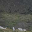
| 580990 | RECORDING | FIELD VISIT | What may be a small plot of lazy-bed cultivation occupies a terrace overlooking Glen Bay from the SW. The furrows are aligned from NW to SE and are between 1.7 to 2.9m apart. [...] | 13 May 2007 |

DP 214071
View of the plot of lazy beds, Gleann Mor, St Kilda.
Records of the Royal Commission on the Ancient and Historical Monuments of Scotland (RCAHMS), Edinbu
7/2009
© Crown Copyright: HES

DP 251134
View of Well Head from SW
Records of the Royal Commission on the Ancient and Historical Monuments of Scotland (RCAHMS), Edinbu
4/2007
© Crown Copyright: HES

DP 251135
Departing St Kilda (Georgina Brown and Ian Parker)
Records of the Royal Commission on the Ancient and Historical Monuments of Scotland (RCAHMS), Edinbu
4/2007
© Crown Copyright: HES

DP 251136
Sign for St Kilda Departure Lounge
Records of the Royal Commission on the Ancient and Historical Monuments of Scotland (RCAHMS), Edinbu
4/2007
© Crown Copyright: HES

DP 251137
St Kilda Departure Lounge
Records of the Royal Commission on the Ancient and Historical Monuments of Scotland (RCAHMS), Edinbu
4/2007
© Crown Copyright: HES

DP 251138
Awaiting helicopter transfer from Balivanich to St Kilda (Ian Parker, Georgina Brown, Angela Gannon)
Records of the Royal Commission on the Ancient and Historical Monuments of Scotland (RCAHMS), Edinbu
4/2007
© Crown Copyright: HES

DP 251139
Enclosure at NF 0966 9927
Records of the Royal Commission on the Ancient and Historical Monuments of Scotland (RCAHMS), Edinbu
4/2007
© Crown Copyright: HES

DP 251140
Structure G, view from SE
Records of the Royal Commission on the Ancient and Historical Monuments of Scotland (RCAHMS), Edinbu
4/2007
© Crown Copyright: HES

DP 251141
Structure G, view from SE
Records of the Royal Commission on the Ancient and Historical Monuments of Scotland (RCAHMS), Edinbu
4/2007
© Crown Copyright: HES

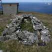
DP 251142
Cleit 2029
Records of the Royal Commission on the Ancient and Historical Monuments of Scotland (RCAHMS), Edinbu
4/2007
© Crown Copyright: HES

DP 251143
Cleit 2029
Records of the Royal Commission on the Ancient and Historical Monuments of Scotland (RCAHMS), Edinbu
4/2007
© Crown Copyright: HES

DP 251144
View of robbed cleit
Records of the Royal Commission on the Ancient and Historical Monuments of Scotland (RCAHMS), Edinbu
4/2007
© Crown Copyright: HES

DP 251145
View of robbed cleit
Records of the Royal Commission on the Ancient and Historical Monuments of Scotland (RCAHMS), Edinbu
4/2007
© Crown Copyright: HES

DP 251146
Cleit 606 with baffle around entrance
Records of the Royal Commission on the Ancient and Historical Monuments of Scotland (RCAHMS), Edinbu
10/5/2007
© Crown Copyright: HES

DP 251147
Cleit 606 with baffle around entrance
Records of the Royal Commission on the Ancient and Historical Monuments of Scotland (RCAHMS), Edinbu
10/5/2007
© Crown Copyright: HES

DP 251148
Cleit 607 with drain. Jill Harden (NTS) with ranging pole
Records of the Royal Commission on the Ancient and Historical Monuments of Scotland (RCAHMS), Edinbu
10/5/2007
© Crown Copyright: HES

DP 251149
Cleit 607, James Hepher with GPS
Records of the Royal Commission on the Ancient and Historical Monuments of Scotland (RCAHMS), Edinbu
10/5/2007
© Crown Copyright: HES

DP 251150
Cleit 613
Records of the Royal Commission on the Ancient and Historical Monuments of Scotland (RCAHMS), Edinbu
10/5/2007
© Crown Copyright: HES

DP 251151
Cleit 641 showing wall construction
Records of the Royal Commission on the Ancient and Historical Monuments of Scotland (RCAHMS), Edinbu
11/5/2007
© Crown Copyright: HES

DP 251152
Cleits 630 and 632
Records of the Royal Commission on the Ancient and Historical Monuments of Scotland (RCAHMS), Edinbu
11/5/2007
© Crown Copyright: HES

DP 251153
James Hepher GPS plotting Cleit 63
Records of the Royal Commission on the Ancient and Historical Monuments of Scotland (RCAHMS), Edinbu
11/5/2007
© Crown Copyright: HES

DP 251154
Cleit 648
Records of the Royal Commission on the Ancient and Historical Monuments of Scotland (RCAHMS), Edinbu
11/5/2007
© Crown Copyright: HES

DP 251155
James Hepher GPS plotting Cleits 643 and 2058
Records of the Royal Commission on the Ancient and Historical Monuments of Scotland (RCAHMS), Edinbu
11/5/2007
© Crown Copyright: HES

DP 251156
Cleit 653
Records of the Royal Commission on the Ancient and Historical Monuments of Scotland (RCAHMS), Edinbu
11/5/2007
© Crown Copyright: HES

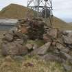
DP 251157
James Hepher GPS plotting Cleit 666 and 292457 Radar Station, with Boreray in the background
Records of the Royal Commission on the Ancient and Historical Monuments of Scotland (RCAHMS), Edinbu
11/5/2007
© Crown Copyright: HES

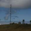
DP 251158
Cleit 665 with Radar Station in background (292457)
Records of the Royal Commission on the Ancient and Historical Monuments of Scotland (RCAHMS), Edinbu
11/5/2007
© Crown Copyright: HES

DP 251159
Cleit 667 with James Hepher and Boreray
Records of the Royal Commission on the Ancient and Historical Monuments of Scotland (RCAHMS), Edinbu
11/5/2007
© Crown Copyright: HES

DP 251160
Cleit 668 and Radar Station (292457)
Records of the Royal Commission on the Ancient and Historical Monuments of Scotland (RCAHMS), Edinbu
11/5/2007
© Crown Copyright: HES

DP 251161
Jill Harden (NTS) photographing Cleit 671
Records of the Royal Commission on the Ancient and Historical Monuments of Scotland (RCAHMS), Edinbu
11/5/2007
© Crown Copyright: HES

DP 251162
Cleit 654 and Radar Station (292457)
Records of the Royal Commission on the Ancient and Historical Monuments of Scotland (RCAHMS), Edinbu
11/5/2007
© Crown Copyright: HES

DP 251163
Cleit 670 overlooking Village Bay
Records of the Royal Commission on the Ancient and Historical Monuments of Scotland (RCAHMS), Edinbu
11/5/2007
© Crown Copyright: HES

DP 251164
Jill Harden (NTS) noting Cleit 673
Records of the Royal Commission on the Ancient and Historical Monuments of Scotland (RCAHMS), Edinbu
11/5/2007
© Crown Copyright: HES

DP 251165
View from E
Records of the Royal Commission on the Ancient and Historical Monuments of Scotland (RCAHMS), Edinbu
12/5/2007
© Crown Copyright: HES

DP 251166
Cleit 478 with Jill Harden (NTS)
Records of the Royal Commission on the Ancient and Historical Monuments of Scotland (RCAHMS), Edinbu
12/5/2007
© Crown Copyright: HES

DP 251167
Cleit 479 with drain; cleit has been rebuilt
Records of the Royal Commission on the Ancient and Historical Monuments of Scotland (RCAHMS), Edinbu
12/5/2007
© Crown Copyright: HES

DP 251168
Cleit 484
Records of the Royal Commission on the Ancient and Historical Monuments of Scotland (RCAHMS), Edinbu
12/5/2007
© Crown Copyright: HES

DP 251169
Cleit 485
Records of the Royal Commission on the Ancient and Historical Monuments of Scotland (RCAHMS), Edinbu
12/5/2007
© Crown Copyright: HES

DP 251170
Jill Harden (NTS) and James Hepher having teabreak
Records of the Royal Commission on the Ancient and Historical Monuments of Scotland (RCAHMS), Edinbu
12/5/2007
© Crown Copyright: HES

DP 251171
Possible structure (dbase 2060) underlying head dyke
Records of the Royal Commission on the Ancient and Historical Monuments of Scotland (RCAHMS), Edinbu
12/5/2007
© Crown Copyright: HES

DP 251172
Cleit 476 showing crude outer walling
Records of the Royal Commission on the Ancient and Historical Monuments of Scotland (RCAHMS), Edinbu
12/5/2007
© Crown Copyright: HES

DP 251173
Cleit 494 with downslope end set on slab
Records of the Royal Commission on the Ancient and Historical Monuments of Scotland (RCAHMS), Edinbu
12/5/2007
© Crown Copyright: HES

DP 251174
Jill Harden (NTS) and James Hepher at Cleit 677
Records of the Royal Commission on the Ancient and Historical Monuments of Scotland (RCAHMS), Edinbu
12/5/2007
© Crown Copyright: HES

DP 251175
James Hepher lying in Cleit 679
Records of the Royal Commission on the Ancient and Historical Monuments of Scotland (RCAHMS), Edinbu
12/5/2007
© Crown Copyright: HES

DP 251176
Cleits 686 and 687
Records of the Royal Commission on the Ancient and Historical Monuments of Scotland (RCAHMS), Edinbu
12/5/2007
© Crown Copyright: HES

DP 251177
Interior of Cleit 686
Records of the Royal Commission on the Ancient and Historical Monuments of Scotland (RCAHMS), Edinbu
12/5/2007
© Crown Copyright: HES

DP 251178
Interior of Cleit 686
Records of the Royal Commission on the Ancient and Historical Monuments of Scotland (RCAHMS), Edinbu
12/5/2007
© Crown Copyright: HES

DP 251179
James Hepher with GPS at Cleit 686
Records of the Royal Commission on the Ancient and Historical Monuments of Scotland (RCAHMS), Edinbu
12/5/2007
© Crown Copyright: HES

DP 251180
Cleit 682 with blocking stones
Records of the Royal Commission on the Ancient and Historical Monuments of Scotland (RCAHMS), Edinbu
12/5/2007
© Crown Copyright: HES

DP 251181
Cleit 689
Records of the Royal Commission on the Ancient and Historical Monuments of Scotland (RCAHMS), Edinbu
12/5/2007
© Crown Copyright: HES

DP 251182
Jill Harden (NTS) noting Cleit 684, view from NE
Records of the Royal Commission on the Ancient and Historical Monuments of Scotland (RCAHMS), Edinbu
12/5/2007
© Crown Copyright: HES

DP 251183
Cleit 697 from SE
Records of the Royal Commission on the Ancient and Historical Monuments of Scotland (RCAHMS), Edinbu
12/5/2007
© Crown Copyright: HES

DP 251184
Cleit 695 from SE
Records of the Royal Commission on the Ancient and Historical Monuments of Scotland (RCAHMS), Edinbu
12/5/2007
© Crown Copyright: HES

DP 251185
Cleit 694
Records of the Royal Commission on the Ancient and Historical Monuments of Scotland (RCAHMS), Edinbu
12/5/2007
© Crown Copyright: HES

DP 251186
Cleit 694
Records of the Royal Commission on the Ancient and Historical Monuments of Scotland (RCAHMS), Edinbu
12/5/2007
© Crown Copyright: HES

DP 251187
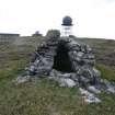
James Hepher at Triangulation Pillar
Records of the Royal Commission on the Ancient and Historical Monuments of Scotland (RCAHMS), Edinbu
12/5/2007
© Crown Copyright: HES

DP 251188
Plate on Triangulation Pillar
Records of the Royal Commission on the Ancient and Historical Monuments of Scotland (RCAHMS), Edinbu
12/5/2007
© Crown Copyright: HES

DP 251189
Cleit 669 overlooking Village Bay
Records of the Royal Commission on the Ancient and Historical Monuments of Scotland (RCAHMS), Edinbu
12/5/2007
© Crown Copyright: HES

DP 251190
James Hepher photographing Cleit 669
Records of the Royal Commission on the Ancient and Historical Monuments of Scotland (RCAHMS), Edinbu
12/5/2007
© Crown Copyright: HES

DP 251191
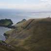
View from Conachair
Records of the Royal Commission on the Ancient and Historical Monuments of Scotland (RCAHMS), Edinbu
12/5/2007
© Crown Copyright: HES

DP 251192
View from Conachair
Records of the Royal Commission on the Ancient and Historical Monuments of Scotland (RCAHMS), Edinbu
12/5/2007
© Crown Copyright: HES

DP 251193
View from Conachair
Records of the Royal Commission on the Ancient and Historical Monuments of Scotland (RCAHMS), Edinbu
12/5/2007
© Crown Copyright: HES

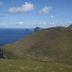
DP 251225
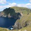
Soay from Geo na Stacan, Hirta
Records of the Royal Commission on the Ancient and Historical Monuments of Scotland (RCAHMS), Edinbu
13/5/2007
© Crown Copyright: HES

DP 251226
Soay from NW Hirta
Records of the Royal Commission on the Ancient and Historical Monuments of Scotland (RCAHMS), Edinbu
13/5/2007
© Crown Copyright: HES

DP 251227
Soay from NW Hirta
Records of the Royal Commission on the Ancient and Historical Monuments of Scotland (RCAHMS), Edinbu
13/5/2007
© Crown Copyright: HES

DP 251228
GPS plotting and noting Cleit 267
Records of the Royal Commission on the Ancient and Historical Monuments of Scotland (RCAHMS), Edinbu
13/5/2007
© Crown Copyright: HES

DP 251229
Kathleen Jamie looking across to the Cleit 267
Records of the Royal Commission on the Ancient and Historical Monuments of Scotland (RCAHMS), Edinbu
13/5/2007
© Crown Copyright: HES

DP 251230
Cleit 171
Records of the Royal Commission on the Ancient and Historical Monuments of Scotland (RCAHMS), Edinbu
13/5/2007
© Crown Copyright: HES

DP 251231
Ian Parker GPS plotting the wall cross the Cambir
Records of the Royal Commission on the Ancient and Historical Monuments of Scotland (RCAHMS), Edinbu
13/5/2007
© Crown Copyright: HES

DP 251232
Wall across the Cambir from NW
Records of the Royal Commission on the Ancient and Historical Monuments of Scotland (RCAHMS), Edinbu
13/5/2007
© Crown Copyright: HES

DP 251233
Cleit 172
Records of the Royal Commission on the Ancient and Historical Monuments of Scotland (RCAHMS), Edinbu
13/5/2007
© Crown Copyright: HES

DP 251234
Head Dyke and Cleits
Records of the Royal Commission on the Ancient and Historical Monuments of Scotland (RCAHMS), Edinbu
13/5/2007
© Crown Copyright: HES

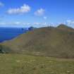
DP 251235
View E across Gleann Mor to Mullach Mor
Records of the Royal Commission on the Ancient and Historical Monuments of Scotland (RCAHMS), Edinbu
13/5/2007
© Crown Copyright: HES

DP 251236
View E across Gleann Mor to Mullach Mor
Records of the Royal Commission on the Ancient and Historical Monuments of Scotland (RCAHMS), Edinbu
13/5/2007
© Crown Copyright: HES

DP 251237
Cleit 173
Records of the Royal Commission on the Ancient and Historical Monuments of Scotland (RCAHMS), Edinbu
13/5/2007
© Crown Copyright: HES

DP 251238
Cleit 173
Records of the Royal Commission on the Ancient and Historical Monuments of Scotland (RCAHMS), Edinbu
13/5/2007
© Crown Copyright: HES

DP 251239
Cleit 173
Records of the Royal Commission on the Ancient and Historical Monuments of Scotland (RCAHMS), Edinbu
13/5/2007
© Crown Copyright: HES

DP 251240
Cleit 2063
Records of the Royal Commission on the Ancient and Historical Monuments of Scotland (RCAHMS), Edinbu
14/5/2007
© Crown Copyright: HES

DP 251241
Cleit 529 with 2061 in background
Records of the Royal Commission on the Ancient and Historical Monuments of Scotland (RCAHMS), Edinbu
14/5/2007
© Crown Copyright: HES

DP 251242
Cleit 531
Records of the Royal Commission on the Ancient and Historical Monuments of Scotland (RCAHMS), Edinbu
14/5/2007
© Crown Copyright: HES

DP 251243
Cleit 533
Records of the Royal Commission on the Ancient and Historical Monuments of Scotland (RCAHMS), Edinbu
14/5/2007
© Crown Copyright: HES

DP 251244
Cleit 533
Records of the Royal Commission on the Ancient and Historical Monuments of Scotland (RCAHMS), Edinbu
14/5/2007
© Crown Copyright: HES

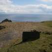
DP 251245
Concrete Stance
Records of the Royal Commission on the Ancient and Historical Monuments of Scotland (RCAHMS), Edinbu
14/5/2007
© Crown Copyright: HES

DP 251246
Database 2080 Triangular concrete stanchion
Records of the Royal Commission on the Ancient and Historical Monuments of Scotland (RCAHMS), Edinbu
14/5/2007
© Crown Copyright: HES

DP 251247
Christine McPherson, Work Party cook
Records of the Royal Commission on the Ancient and Historical Monuments of Scotland (RCAHMS), Edinbu
14/5/2007
© Crown Copyright: HES

DP 251248
Christine McPherson, Work Party cook
Records of the Royal Commission on the Ancient and Historical Monuments of Scotland (RCAHMS), Edinbu
14/5/2007
© Crown Copyright: HES

DP 251249
Christine McPherson, Work Party cook
Records of the Royal Commission on the Ancient and Historical Monuments of Scotland (RCAHMS), Edinbu
14/5/2007
© Crown Copyright: HES

DP 251250
Ian Parker and Samantha Dennis (NTS)
Records of the Royal Commission on the Ancient and Historical Monuments of Scotland (RCAHMS), Edinbu
14/5/2007
© Crown Copyright: HES

DP 251251
Ian Parker and Samantha Dennis (NTS)
Records of the Royal Commission on the Ancient and Historical Monuments of Scotland (RCAHMS), Edinbu
14/5/2007
© Crown Copyright: HES

DP 251252
Jill Harden (NTS), Kathleen Jamie, Adam Welfare, John Wills and James Hepher
Records of the Royal Commission on the Ancient and Historical Monuments of Scotland (RCAHMS), Edinbu
14/5/2007
© Crown Copyright: HES

DP 251253
Survey Noticeboard and rota
Records of the Royal Commission on the Ancient and Historical Monuments of Scotland (RCAHMS), Edinbu
14/5/2007
© Crown Copyright: HES

DP 251254
Cleit 550
Records of the Royal Commission on the Ancient and Historical Monuments of Scotland (RCAHMS), Edinbu
14/5/2007
© Crown Copyright: HES

DP 251255
Cleit 550
Records of the Royal Commission on the Ancient and Historical Monuments of Scotland (RCAHMS), Edinbu
14/5/2007
© Crown Copyright: HES

DP 251256
Cleit 550
Records of the Royal Commission on the Ancient and Historical Monuments of Scotland (RCAHMS), Edinbu
14/5/2007
© Crown Copyright: HES

DP 251257
Cleit 516, drain at downslope end
Records of the Royal Commission on the Ancient and Historical Monuments of Scotland (RCAHMS), Edinbu
14/5/2007
© Crown Copyright: HES

DP 251258
Cleits 2073-5
Records of the Royal Commission on the Ancient and Historical Monuments of Scotland (RCAHMS), Edinbu
14/5/2007
© Crown Copyright: HES

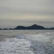
DP 251259
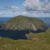
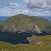
Boreray from the sea
Records of the Royal Commission on the Ancient and Historical Monuments of Scotland (RCAHMS), Edinbu
15/5/2007
© Crown Copyright: HES

DP 251260
Cleit 538
Records of the Royal Commission on the Ancient and Historical Monuments of Scotland (RCAHMS), Edinbu
15/5/2007
© Crown Copyright: HES

DP 251261
Cleit 540
Records of the Royal Commission on the Ancient and Historical Monuments of Scotland (RCAHMS), Edinbu
15/5/2007
© Crown Copyright: HES

DP 251262
Cleit 545
Records of the Royal Commission on the Ancient and Historical Monuments of Scotland (RCAHMS), Edinbu
15/5/2007
© Crown Copyright: HES

DP 251263
Dun, Hirta and Soay from the sea
Records of the Royal Commission on the Ancient and Historical Monuments of Scotland (RCAHMS), Edinbu
15/5/2007
© Crown Copyright: HES


First 100 images shown.
