
Following the launch of trove.scot in February 2025 we are now planning the retiral of some of our webservices. Canmore will be switched off on 24th June 2025. Information about the closure can be found on the HES website: Retiral of HES web services | Historic Environment Scotland
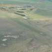
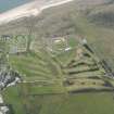
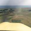
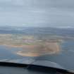
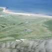
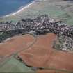
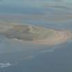
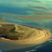
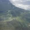
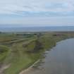
Dornoch Airfield


Airfield (20th Century)
Site Name Dornoch Airfield
Classification Airfield (20th Century)
Alternative Name(s) Dornoch Landing Strip
Canmore ID 93105
Site Number NH88NW 4
NGR NH 8004 8842
NGR Description Centred NH 8004 8842
Datum OSGB36 - NGR
Permalink http://canmore.org.uk/site/93105


- Council Highland
- Parish Dornoch
- Former Region Highland
- Former District Sutherland
- Former County Sutherland
NH88NW 4 centred 8004 8842
(NH 800 885) Selected as a Satellite Landing Ground it closed during 1945. Re-opening in 1967, services to Inverness and Wick proved uneconomic. Occasionally still used.
D J Smith 1983.
Dornoch airstrip is situated to the S of the town and W of the dunes. Only the airstrip could be seen on the date of visit.
J Guy 2000; NMRS MS 810/10, Vol.2, 109

