
St Kilda, Hirta, An Lag Bho'n Tuath


Enclosure(S) (Post Medieval)
Site Name St Kilda, Hirta, An Lag Bho'n Tuath
Classification Enclosure(S) (Post Medieval)
Canmore ID 92179
Site Number NF19NW 27
NGR NF 104 996
NGR Description Centred NF 104 996
Datum OSGB36 - NGR
Permalink http://canmore.org.uk/site/92179
Ordnance Survey licence number AC0000807262. All rights reserved.
Canmore Disclaimer.
© Bluesky International Limited 2025. Public Sector Viewing Terms
- Correction
- Favourite

DP 044873
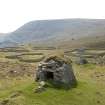
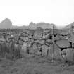
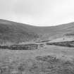
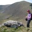
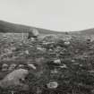
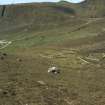
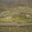
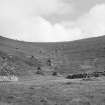
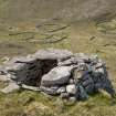
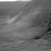
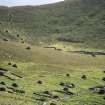
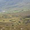
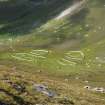
Hirta, An Lag Bho'n Tuath. View of enclosures from NE with cleit 1043 in foreground.
Records of the Royal Commission on the Ancient and Historical Monuments of Scotland (RCAHMS), Edinbu
13/5/2008
© Crown Copyright: HES

DP 044874
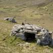
Hirta, An Lag Bho'n Tuath. View of enclosures from NE with cleits 1039 and 1042-3 in the middle distance.
Records of the Royal Commission on the Ancient and Historical Monuments of Scotland (RCAHMS), Edinbu
13/5/2008
© Crown Copyright: HES

DP 044883
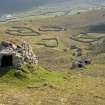
Hirta, An Lag Bho'n Tuath. View of enclosures from NE with cleit 1049 in the foreground.
Records of the Royal Commission on the Ancient and Historical Monuments of Scotland (RCAHMS), Edinbu
13/5/2008
© Crown Copyright: HES

DP 134208
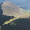
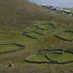
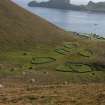
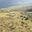
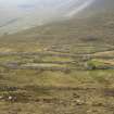
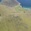
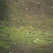
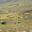
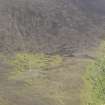
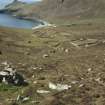
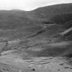
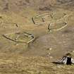
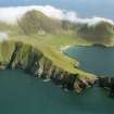
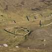
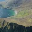
General oblique aerial view of St Kilda, centred on Village Bay and enclosures at An Lag Bho'n Tuath, taken from the NW.
RCAHMS Aerial Photography Digital
2/5/2012
© Crown Copyright: HES

SC 1445431
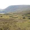
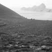
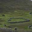
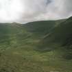
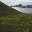
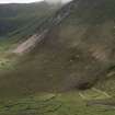
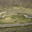
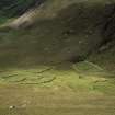
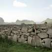
An Lag Bho'n Tuath. General view of enclosures from North West.
Records of the Royal Commission on the Ancient and Historical Monuments of Scotland (RCAHMS), Edinbu
1983
© Crown Copyright: HES

SC 1445435
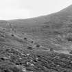
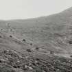
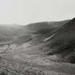
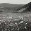
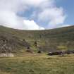
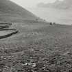
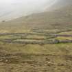
An Lag Bho'n Tuath. General view.
Records of the Royal Commission on the Ancient and Historical Monuments of Scotland (RCAHMS), Edinbu
1983
© Crown Copyright: HES

DP 197685
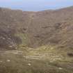
General view of An Lag, St Kilda.
Records of the Royal Commission on the Ancient and Historical Monuments of Scotland (RCAHMS), Edinbu
26/8/2014
© Crown Copyright: HES

DP 222300
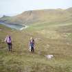
Working shot, RCAHMS St Kilda 2008.
Records of the Royal Commission on the Ancient and Historical Monuments of Scotland (RCAHMS), Edinbu
5/2008
© Crown Copyright: HES

DP 251400
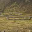
View of enclosures from N
Records of the Royal Commission on the Ancient and Historical Monuments of Scotland (RCAHMS), Edinbu
6/9/2007
© Crown Copyright: HES

DP 251401
View of enclosures from N
Records of the Royal Commission on the Ancient and Historical Monuments of Scotland (RCAHMS), Edinbu
6/9/2007
© Crown Copyright: HES

DP 251611
View from NW
Records of the Royal Commission on the Ancient and Historical Monuments of Scotland (RCAHMS), Edinbu
4/9/2008
© Crown Copyright: HES

DP 258162
General view of An Lag Bho 'n Tuath
Historic Environment Scotland
9/8/2017
© Crown Copyright: HES

SC 416633
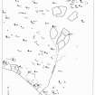
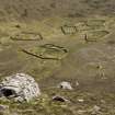
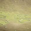
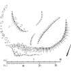
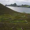
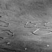
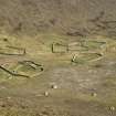
Publication drawing; St Kilda, An Lag Bho 'n Tuath, distribution plan. Photographic copy.
Records of the Royal Commission on the Ancient and Historical Monuments of Scotland (RCAHMS), Edinbu
c. 1986
© Crown Copyright: HES

SC 793995
An Lag Bho'n Tuath. Detail of enclosure. Digital image of B 11248
1983
© RCAHMS

DP 044884
Hirta, An Lag Bho'n Tuath. View of enclosures from NE with cleits 1039-40 and 1042-44 in the middle distance.
Records of the Royal Commission on the Ancient and Historical Monuments of Scotland (RCAHMS), Edinbu
13/5/2008
© Crown Copyright: HES

DP 044894
An Lag Bho'n Tuath, enclosures. View from E of S enclosures.
Records of the Royal Commission on the Ancient and Historical Monuments of Scotland (RCAHMS), Edinbu
13/5/2008
© Crown Copyright: HES

DP 044898
Hirta, An Lag Bho'n Tuath. View of enclosures from E.
Records of the Royal Commission on the Ancient and Historical Monuments of Scotland (RCAHMS), Edinbu
13/5/2008
© Crown Copyright: HES

SC 1433230
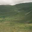
An Lag Bho'n Tuath. General view from East.
Records of the Royal Commission on the Ancient and Historical Monuments of Scotland (RCAHMS), Edinbu
1983
© Crown Copyright: HES

SC 1445433
An Lag Bho'n Tuath. General view of enclosures from South West.
Records of the Royal Commission on the Ancient and Historical Monuments of Scotland (RCAHMS), Edinbu
1983
© Crown Copyright: HES

SC 1445469
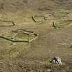
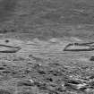
An Lag Bho'n Tuath. General view of Cottam Structure 16.
Records of the Royal Commission on the Ancient and Historical Monuments of Scotland (RCAHMS), Edinbu
1983
© Crown Copyright: HES

SC 1445471
St Kilda, An Lag Bho'n Tuath. General view.
Records of the Royal Commission on the Ancient and Historical Monuments of Scotland (RCAHMS), Edinbu
1983
© Crown Copyright: HES

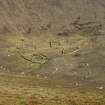
SC 1463896
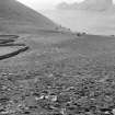
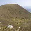
St Kilda, An Lag Bho'n Tuath. Elevated view across the enclosures to Creagan Dubh.
Records of the Royal Commission on the Ancient and Historical Monuments of Scotland (RCAHMS), Edinbu
7/1986
© Crown Copyright: HES

SC 1463897
St Kilda, An Lag Bho'n Tuath. Elevated view across the enclosures to Creagan Dubh.
Records of the Royal Commission on the Ancient and Historical Monuments of Scotland (RCAHMS), Edinbu
7/1986
© Crown Copyright: HES

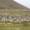
SC 1463974
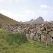
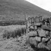
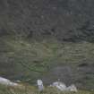
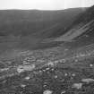
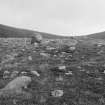
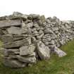
St Kilda, An Lag Bho'n Tuath. Detail of enclosure wall.
Records of the Royal Commission on the Ancient and Historical Monuments of Scotland (RCAHMS), Edinbu
7/1986
© Crown Copyright: HES

DP 222302
Working shot, RCAHMS St Kilda 2008.
Records of the Royal Commission on the Ancient and Historical Monuments of Scotland (RCAHMS), Edinbu
5/2008
© Crown Copyright: HES

DP 251609
View from N
Records of the Royal Commission on the Ancient and Historical Monuments of Scotland (RCAHMS), Edinbu
4/9/2008
© Crown Copyright: HES

SC 2644909
An Lag Bho'n Tuath. General view of eclosures from East.
Records of the Royal Commission on the Ancient and Historical Monuments of Scotland (RCAHMS), Edinbu
1986
© Crown Copyright: HES

SC 2644910
An Lag Bho'n Tuath. General view from East.
Records of the Royal Commission on the Ancient and Historical Monuments of Scotland (RCAHMS), Edinbu
1986
© Crown Copyright: HES

SC 2644937
An Lag Bho'n Tuath. General view of enclosures from North West.
Records of the Royal Commission on the Ancient and Historical Monuments of Scotland (RCAHMS), Edinbu
1986
© Crown Copyright: HES

SC 2644942
An Lag Bho'n Tuath. View of enclosure walls from West.
Records of the Royal Commission on the Ancient and Historical Monuments of Scotland (RCAHMS), Edinbu
1986
© Crown Copyright: HES

SC 2644971
An Lag Bho'n Tuath. General view of Cottam Structure 16.
Records of the Royal Commission on the Ancient and Historical Monuments of Scotland (RCAHMS), Edinbu
1986
© Crown Copyright: HES

DP 044900
Hirta, An Lag Bho'n Tuath. View of enclosures from W with cleit 961 in the foreground.
Records of the Royal Commission on the Ancient and Historical Monuments of Scotland (RCAHMS), Edinbu
13/5/2008
© Crown Copyright: HES

DP 134212
General oblique aerial view of St Kilda, centred on Mullach Mor Radar Station, taken from the NW.
RCAHMS Aerial Photography Digital
2/5/2012
© Crown Copyright: HES

SC 1433213
An Lag Bho'n Tuath. General view of enclosures from North East.
Records of the Royal Commission on the Ancient and Historical Monuments of Scotland (RCAHMS), Edinbu
1983
© Crown Copyright: HES

SC 1445436
An Lag Bho'n Tuath. General view of enclosures from West.
Records of the Royal Commission on the Ancient and Historical Monuments of Scotland (RCAHMS), Edinbu
1983
© Crown Copyright: HES

SC 1445438
An Lag Bho'n Tuath. View of enclosure walls from West.
Records of the Royal Commission on the Ancient and Historical Monuments of Scotland (RCAHMS), Edinbu
1983
© Crown Copyright: HES

SC 1463213
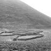
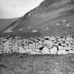
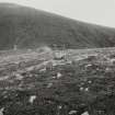
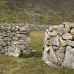
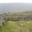
A detail of a section of wall of the enclosures at An Lag Bho'n Tuath, St Kilda.
Historic Scotland Archive Project
1957
© Courtesy of HES (Sponsored Excavations)

SC 1463899
St Kilda, An Lag Bho'n Tuath. Elevated view across the enclosures to Glacan Chonchair.
Records of the Royal Commission on the Ancient and Historical Monuments of Scotland (RCAHMS), Edinbu
7/1986
© Crown Copyright: HES

SC 1463928
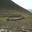
St Kilda, An Lag Bho'n Tuath. Enclosures.
Records of the Royal Commission on the Ancient and Historical Monuments of Scotland (RCAHMS), Edinbu
7/1986
© Crown Copyright: HES

SC 1463932
St Kilda, An Lag Bho'n Tuath. Enclosures.
Records of the Royal Commission on the Ancient and Historical Monuments of Scotland (RCAHMS), Edinbu
7/1986
© Crown Copyright: HES

SC 1475432
View westwards from An Lag.
Papers of Dr J N Graham Ritchie, and Dr Anna Ritchie, archaeologists, Edinburgh, Scotland
9/2000
© RCAHMS

DP 251610
View from N
Records of the Royal Commission on the Ancient and Historical Monuments of Scotland (RCAHMS), Edinbu
4/9/2008
© Crown Copyright: HES

SC 2644538
An Lag Bho'n Tuath. General view of enclosures from South West.
Records of the Royal Commission on the Ancient and Historical Monuments of Scotland (RCAHMS), Edinbu
1986
© Crown Copyright: HES

SC 2644939
An Lag Bho'n Tuath. General view of enclosures from South West.
Records of the Royal Commission on the Ancient and Historical Monuments of Scotland (RCAHMS), Edinbu
1986
© Crown Copyright: HES

SC 2644940
An Lag Bho'n Tuath. General view of enclosures from West.
Records of the Royal Commission on the Ancient and Historical Monuments of Scotland (RCAHMS), Edinbu
1986
© Crown Copyright: HES

DP 044878
Hirta, An Lag Bho'n Tuath. General view of enclosures from NNW.
Records of the Royal Commission on the Ancient and Historical Monuments of Scotland (RCAHMS), Edinbu
13/5/2008
© Crown Copyright: HES

DP 044885
An Lag Bho'n Tuath, enclosures. Detail of enclosure wall.
Records of the Royal Commission on the Ancient and Historical Monuments of Scotland (RCAHMS), Edinbu
13/5/2008
© Crown Copyright: HES

DP 044886
An Lag Bho'n Tuath, enclosures. Detail of enclosure wall.
Records of the Royal Commission on the Ancient and Historical Monuments of Scotland (RCAHMS), Edinbu
13/5/2008
© Crown Copyright: HES

DP 044891
An Lag Bho'n Tuath, enclosures. View from W of N enclosures.
Records of the Royal Commission on the Ancient and Historical Monuments of Scotland (RCAHMS), Edinbu
13/5/2008
© Crown Copyright: HES

DP 044895
An Lag Bho'n Tuath, enclosures. View from W of N enclosures.
Records of the Royal Commission on the Ancient and Historical Monuments of Scotland (RCAHMS), Edinbu
13/5/2008
© Crown Copyright: HES

DP 134134
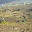
General oblique aerial view of St Kilda, centred on enclosures at An Lag Bho'n Tuath, taken from the NW.
RCAHMS Aerial Photography Digital
2/5/2012
© Crown Copyright: HES

SC 1431964
Publication drawing; St Kilda, plan of ?enclosure (at NF 1030 9967). Photographic copy.
Records of the Royal Commission on the Ancient and Historical Monuments of Scotland (RCAHMS), Edinbu
13/1/1987
© Crown Copyright: HES

SC 1445439
An Lag Bho'n Tuath. General view of enclosures from South.
Records of the Royal Commission on the Ancient and Historical Monuments of Scotland (RCAHMS), Edinbu
1983
© Crown Copyright: HES

SC 1463898
St Kilda, An Lag Bho'n Tuath. Elevated view across the enclosures to Glacan Chonchair.
Records of the Royal Commission on the Ancient and Historical Monuments of Scotland (RCAHMS), Edinbu
7/1986
© Crown Copyright: HES

DP 251192
View from Conachair
Records of the Royal Commission on the Ancient and Historical Monuments of Scotland (RCAHMS), Edinbu
12/5/2007
© Crown Copyright: HES

DP 251518
View from NNE
Records of the Royal Commission on the Ancient and Historical Monuments of Scotland (RCAHMS), Edinbu
7/2004
© Crown Copyright: HES

DP 251608
View from N
Records of the Royal Commission on the Ancient and Historical Monuments of Scotland (RCAHMS), Edinbu
4/9/2008
© Crown Copyright: HES

SC 2644898
An Lag Bho'n Tuath. General view of enclosures from North East.
Records of the Royal Commission on the Ancient and Historical Monuments of Scotland (RCAHMS), Edinbu
1986
© Crown Copyright: HES

SC 722685
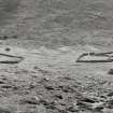
Vertical aerial photograph showing St Kilda.
Photoair Limited: Aerial Imagery (Scotland)
6/1995
© Courtesy of HES (Photoair Limited: Aerial Imagery (Scotland))

DP 044877
Hirta, An Lag Bho'n Tuath. View of enclosures from NE.
Records of the Royal Commission on the Ancient and Historical Monuments of Scotland (RCAHMS), Edinbu
13/5/2008
© Crown Copyright: HES

DP 044888
An Lag Bho'n Tuath, enclosures. Detail of enclosure wall.
Records of the Royal Commission on the Ancient and Historical Monuments of Scotland (RCAHMS), Edinbu
13/5/2008
© Crown Copyright: HES

DP 044896
the Hirta, An Lag Bho'n Tuath. View of enclosures from E with cleit 1088 in the foreground.
Records of the Royal Commission on the Ancient and Historical Monuments of Scotland (RCAHMS), Edinbu
13/5/2008
© Crown Copyright: HES

DP 044897
Hirta, An Lag Bho'n Tuath. View of enclosures from E with cleit 1084 in the foreground.
Records of the Royal Commission on the Ancient and Historical Monuments of Scotland (RCAHMS), Edinbu
13/5/2008
© Crown Copyright: HES

DP 044899
Hirta, An Lag Bho'n Tuath. View of enclosures from N with cleit 1049 in foreground.
Records of the Royal Commission on the Ancient and Historical Monuments of Scotland (RCAHMS), Edinbu
13/5/2008
© Crown Copyright: HES

DP 044903
Hirta, An Lag Bho'n Tuath. View of enclosures from WNW.
Records of the Royal Commission on the Ancient and Historical Monuments of Scotland (RCAHMS), Edinbu
13/5/2008
© Crown Copyright: HES

DP 134135
General oblique aerial view of St Kilda, centred on enclosures at An Lag Bho'n Tuath, taken from the WNW.
RCAHMS Aerial Photography Digital
2/5/2012
© Crown Copyright: HES

SC 1445432
An Lag Bho'n Tuath. General view of enclosures from North West.
Records of the Royal Commission on the Ancient and Historical Monuments of Scotland (RCAHMS), Edinbu
1983
© Crown Copyright: HES

SC 1445434
An Lag Bho'n Tuath. General view of enclosures from South West.
Records of the Royal Commission on the Ancient and Historical Monuments of Scotland (RCAHMS), Edinbu
1983
© Crown Copyright: HES

SC 1445467
An Lag Bho'n Tuath. General view of Cottam Structure 16.
Records of the Royal Commission on the Ancient and Historical Monuments of Scotland (RCAHMS), Edinbu
1983
© Crown Copyright: HES

SC 1475403
An Lag Bho 'n Tuath, looking SW towards Village Bay.
Papers of Dr J N Graham Ritchie, and Dr Anna Ritchie, archaeologists, Edinburgh, Scotland
6/1984
© RCAHMS

SC 1475410
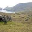
Enclosures at An Lag Bho 'n Tuath above the village.
Papers of Dr J N Graham Ritchie, and Dr Anna Ritchie, archaeologists, Edinburgh, Scotland
6/1984
© RCAHMS

DP 279933
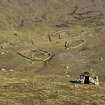
View of peat cutting on the N side of An Lag
Records of the Royal Commission on the Ancient and Historical Monuments of Scotland (RCAHMS), Edinbu
4/4/2007
© Crown Copyright: HES

SC 2644969
An Lag Bho'n Tuath. General view of Cottam Structure 16.
Records of the Royal Commission on the Ancient and Historical Monuments of Scotland (RCAHMS), Edinbu
1986
© Crown Copyright: HES

SC 416635
An Lag Bho'n Tuath. General view of enclosures from North East.
Records of the Royal Commission on the Ancient and Historical Monuments of Scotland (RCAHMS), Edinbu
1986
© Crown Copyright: HES

SC 416636
An Lag Bho'n Tuath. General view of enclosures from West.
Records of the Royal Commission on the Ancient and Historical Monuments of Scotland (RCAHMS), Edinbu
1986
© Crown Copyright: HES

SC 793981
An Lag Bho'n Tuath. General view of enclosures from North East. Digital image of B 11127
Records of the Royal Commission on the Ancient and Historical Monuments of Scotland (RCAHMS), Edinbu
1986
© Crown Copyright: HES

DP 044879
Hirta, An Lag Bho'n Tuath. General view of enclosures from NW with cleit 941 in the foreground.
Records of the Royal Commission on the Ancient and Historical Monuments of Scotland (RCAHMS), Edinbu
13/5/2008
© Crown Copyright: HES

DP 044880
Hirta, An Lag Bho'n Tuath. View of enclosures from NW with cleit 941 in the foreground.
Records of the Royal Commission on the Ancient and Historical Monuments of Scotland (RCAHMS), Edinbu
13/5/2008
© Crown Copyright: HES

DP 044893
An Lag Bho'n Tuath, enclosures. View from E of N enclosures.
Records of the Royal Commission on the Ancient and Historical Monuments of Scotland (RCAHMS), Edinbu
13/5/2008
© Crown Copyright: HES

SC 1445470
An Lag Bho'n Tuath. General view of Cottam Structure 16.
Records of the Royal Commission on the Ancient and Historical Monuments of Scotland (RCAHMS), Edinbu
1986
© Crown Copyright: HES

SC 1467597
St Kilda, An Lag Bho'n Tuath. Enclosures and cleitean.
Records of the Royal Commission on the Ancient and Historical Monuments of Scotland (RCAHMS), Edinbu
7/1986
© Crown Copyright: HES

SC 1467635
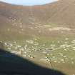
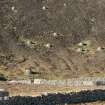
St Kilda, Village Bay. General view facing east looking over the head dyke towards An Lag Bho'n Tuath.
Records of the Royal Commission on the Ancient and Historical Monuments of Scotland (RCAHMS), Edinbu
7/1986
© Crown Copyright: HES

SC 2644970
An Lag Bho'n Tuath. General view of Cottam Structure 16.
Records of the Royal Commission on the Ancient and Historical Monuments of Scotland (RCAHMS), Edinbu
1986
© Crown Copyright: HES

DP 044876
Hirta, An Lag Bho'n Tuath. View of enclosures from NE.
Records of the Royal Commission on the Ancient and Historical Monuments of Scotland (RCAHMS), Edinbu
13/5/2008
© Crown Copyright: HES

DP 044887
An Lag Bho'n Tuath, enclosures. Detail of entrance through enclosure wall.
Records of the Royal Commission on the Ancient and Historical Monuments of Scotland (RCAHMS), Edinbu
13/5/2008
© Crown Copyright: HES

DP 044890
An Lag Bho'n Tuath, enclosures. Detail of entrance through enclosure wall.
Records of the Royal Commission on the Ancient and Historical Monuments of Scotland (RCAHMS), Edinbu
13/5/2008
© Crown Copyright: HES

DP 044901
Hirta, An Lag Bho'n Tuath. General view of enclosures from W with cleit 961 in the foreground and Oiseval beyond.
Records of the Royal Commission on the Ancient and Historical Monuments of Scotland (RCAHMS), Edinbu
13/5/2008
© Crown Copyright: HES

DP 044902
Hirta, An Lag Bho'n Tuath. View of enclosures from W.
Records of the Royal Commission on the Ancient and Historical Monuments of Scotland (RCAHMS), Edinbu
13/5/2008
© Crown Copyright: HES

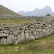
SC 1467598
St Kilda, An Lag Bho'n Tuath. Detail of enclosure wall.
Records of the Royal Commission on the Ancient and Historical Monuments of Scotland (RCAHMS), Edinbu
7/1986
© Crown Copyright: HES

DP 285757
General view
Papers of Dr George F Geddes, archaeologist, Edinburgh, Scotland
19/8/2018
© Copyright: G F Geddes. Courtesy of HES.

SC 2644906
An Lag Bho'n Tuath. General view of enclosures from East.
Records of the Royal Commission on the Ancient and Historical Monuments of Scotland (RCAHMS), Edinbu
1986
© Crown Copyright: HES

SC 2644938
An Lag Bho'n Tuath. General view of enclosures from North West.
Records of the Royal Commission on the Ancient and Historical Monuments of Scotland (RCAHMS), Edinbu
1986
© Crown Copyright: HES

SC 722682
General oblique aerial view of the Hirta centred on the village and remains of the enclosures, taken from the WSW.
Photoair Limited: Aerial Imagery (Scotland)
6/1995
© Courtesy of HES (Photoair Limited: Aerial Imagery (Scotland))

DP 044875
Hirta, An Lag Bho'n Tuath. View of enclosures from NE with cleit 1047 in foreground.
Records of the Royal Commission on the Ancient and Historical Monuments of Scotland (RCAHMS), Edinbu
13/5/2008
© Crown Copyright: HES

DP 044881
Hirta, An Lag Bho'n Tuath. View of enclosures from NW.
Records of the Royal Commission on the Ancient and Historical Monuments of Scotland (RCAHMS), Edinbu
13/5/2008
© Crown Copyright: HES

DP 044882
Hirta, An Lag Bho'n Tuath. View of enclosures from NE with cleit 1049 in the foreground.
Records of the Royal Commission on the Ancient and Historical Monuments of Scotland (RCAHMS), Edinbu
13/5/2008
© Crown Copyright: HES

DP 044889
An Lag Bho'n Tuath, enclosures. Detail of enclosure wall.
Records of the Royal Commission on the Ancient and Historical Monuments of Scotland (RCAHMS), Edinbu
13/5/2008
© Crown Copyright: HES

DP 044892
An Lag Bho'n Tuath, enclosures. View from E of S enclosures.
Records of the Royal Commission on the Ancient and Historical Monuments of Scotland (RCAHMS), Edinbu
13/5/2008
© Crown Copyright: HES

DP 051907
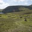
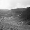
Hirta, An Lag Bho'n Tuath. General view from SW showing the enclosures and the cleits running upslope to The Gap.
Records of the Royal Commission on the Ancient and Historical Monuments of Scotland (RCAHMS), Edinbu
10/5/2008
© Crown Copyright: HES

DP 134207
General oblique aerial view of St Kilda, centred on Village Bay and enclosures at An Lag Bho'n Tuath, taken from the ENE.
RCAHMS Aerial Photography Digital
2/5/2012
© Crown Copyright: HES


First 100 images shown. See the Collections panel (below) for a link to all digital images.
- Council Western Isles
- Parish Harris
- Former Region Western Isles Islands Area
- Former District Western Isles
- Former County Inverness-shire

