
Glasgow, Clyde Street, Union Railway Bridge


Railway Bridge (19th Century) - (20th Century)
Site Name Glasgow, Clyde Street, Union Railway Bridge
Classification Railway Bridge (19th Century) - (20th Century)
Alternative Name(s) River Clyde; Clyde Viaduct, Union Railway; St Enoch Railway Bridge; City Union Railway Bridge; Clyde Street; Adephi Street
Canmore ID 91770
Site Number NS56SE 145.01
NGR NS 59284 64509
Datum OSGB36 - NGR
Permalink http://canmore.org.uk/site/91770


- Council Glasgow, City Of
- Parish Glasgow (City Of Glasgow)
- Former Region Strathclyde
- Former District City Of Glasgow
- Former County Lanarkshire
NS56SE 145 59284 64509
For (former) associated St Enoch Station, see NS56SE 69.00.
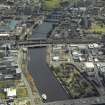
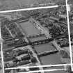
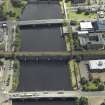
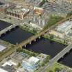
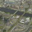
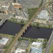
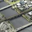
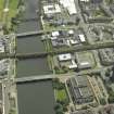
Union Railway Bridge, rebuilt 1898-1902 to serve the extended St Enoch Station (NS56SE 69.00). The original bridge was constructed 1864-7 for the City of Glasgow Union Rly, the contractors being Brassey and Co.
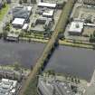
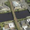
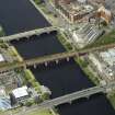
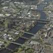
The reconstructed bridge is a five arch structure with steel arches on pairs of stone spans. There are single lattice girder spans at each end leading to the brick arch approaches. The piers are extended upwards to imitate crenellated turrets, and there is a cast-iron Gothic parapet.
J R Hume 1974.
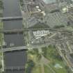
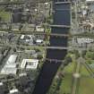
City Union Railway Bridge, 1897-9. Engineer William Melville; contractors Morrison and Mason for foundations and masonry, and Sir William Arrol and Co for steelwork. It carries four lines of track, replacing the two-track bridge of 1870. Five spandrel-braced arches of riveted steelwork over the river, each of two ribs, and a lattice-girder span over the street on each bank. Steel caissons sunk to almost 18m (60ft) below the river-bed support cylindrical piers of rock-faced Shap granite, from which the arch ribs spring at a height of 7.5m (25ft) above low water. A complex system of cross girders between the arches carries the 14m (45ft) wide track bed, the form of the structure having been largely dictated by the need to construct it under the olf bridge, which was still in use. There is a decorative cast iron cornice and parapet on all the river spans, punctuated by crenellated half-turrets of Dumfriesshire red sandstone at the piers, and bigger towers in the same style at the abutments.
The bridge served the main routes from the S to the now-demolished St Enoch Station (NS56SE 69.00).
E Williamson, A Riches and M Higgs 1990.
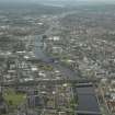
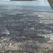
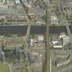
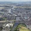
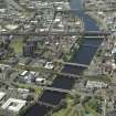
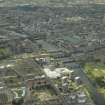
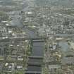
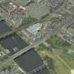
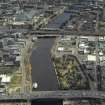
This railway bridge spans the River Clyde to the SE of the former St Enoch Station (NS56SE 69.00) and a short distance upstream (to the SE) of Victoria Bridge (NS56SE 24). It formerly carried the approach tracks into that station from the Glasgow and South-Western Rly's network in SW Scotland. Since the closure of the station, it has remained in service (with a reduced number of tracks) as a major element in the 'avoiding line' that passes around the E side of central Glasgow.
The river here forms the boundary between the parishes of Glasgow (to the NE) and Goavn (to the SW). The approach spans cross Clyde St and Adelphi St, to the NE and SW respectively of the river.
The location assigned to this record defines the centre of the span. The bridge is depicted, but not noted, on the 1969 edition of the OS 1:1250 map. The available map evidence indicates that the bridge itself extends from NS c. 59321 64565 to NS c. 59429 64451; inclusion of the approach spans extends the structure from NS c. 59330 64582 to NS c. 59237 64438.
Information from RCAHMS (RJCM), 15 December 2005.
Construction (1897 - 1898)
William Melville - engineer
Hanna, Donald and Wilson, Paisley - contractors
Project (2007)
This project was undertaken to input site information listed in 'Civil engineering heritage: Scotland - Lowlands and Borders' by R Paxton and J Shipway, 2007.
Publication Account (2007)
This viaduct, erected from 1897–98 by the Glasgow & South Western Railway, developed the existing twin-line
strategic crossing of the Clyde to carry four lines of track into St Enoch’s Station. But its curious appearance as five spandrel braced arches of riveted steelwork, three spans of 84 1/2 ft and two of 69 ft, each consisting of two ribs, and a lattice girder span over adjacent streets at each bank, is misleading. In fact, the structure consists of two variable depth (8 1/4– 24 ft) continuous girders supported on cast-steel bearings, which were fabricated either side of and below the 1870 superstructure. The girders are fixed at the two centre piers but with expansion rollers at the two landward piers and abutment. There is a decorative cast-iron cornice and parapet on all river spans, with crenellated half turrets of red sandstone at the piers, and abutment towers in the same style.
The 1898 bridge is founded on 13 ft diameter steel piers sunk by means of compressed air to within 2–3 ft of the bottom of the existing cylinders. The engineer was William Melville and the contractors, Hanna, Donald & Wilson, Paisley and Sir Wm. Arrol & Co. (steelwork). The cost was £67 970. Although St Enoch’s Station was closed in 1966 and subsequently demolished, the viaduct is still in use, mainly for freight traffic.
R Paxton and J Shipway 2007
Reproduced from 'Civil Engineering heritage: Scotland - Lowlands and Borders' with kind permission of Thomas Telford Publishers.

