
Pricing Change
New pricing for orders of material from this site will come into place shortly. Charges for supply of digital images, digitisation on demand, prints and licensing will be altered.
Noss Head, North Mounds


Mound(S) (Period Unassigned)
Site Name Noss Head, North Mounds
Classification Mound(S) (Period Unassigned)
Alternative Name(s) Wic 144
Canmore ID 9162
Site Number ND35SE 31
NGR ND 3808 5498
Datum OSGB36 - NGR
Permalink http://canmore.org.uk/site/9162


- Council Highland
- Parish Wick
- Former Region Highland
- Former District Caithness
- Former County Caithness
ND35SE 31 3808 5498.
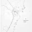
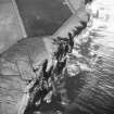
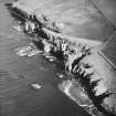
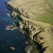
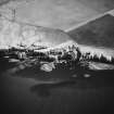
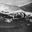
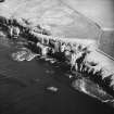
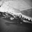
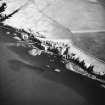
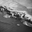
(Centred ND 3805 5500) Grass-covered mounds, between 4 and 5m across, surrounded by flat ditches and lying 6 to 12m apart. Possibly beacons.
C E Batey 1981.
The mounds at ND 3808 5498 are as described and planned by Miss Batey. They appear to be modern, 19th / 20th century and constructed for uncertain military purposes. The drainage ditch is later than the mounds.
Visited by OS (J B) 22 July 1982.
Project (1980 - 1982)
Field Visit (1981)
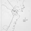
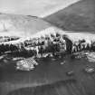
(Centred ND 3805 5500) Grass-covered mounds, between 4 and 5m across, surrounded by flat ditches and lying 6 to 12m apart. Possibly beacons.
C E Batey 1981.
Field Visit (22 July 1982)
The mounds at ND 3808 5498 are as described and planned by Miss Batey. They appear to be modern, 19th / 20th century and constructed for uncertain military purposes. The drainage ditch is later than the mounds.
Visited by OS (J B) 22 July 1982.

