
Garrywhin


Enclosure(S) (Period Unassigned), Fort (Period Unassigned), Pen(S) (Period Unassigned), Quarry(S) (Period Unassigned)
Site Name Garrywhin
Classification Enclosure(S) (Period Unassigned), Fort (Period Unassigned), Pen(S) (Period Unassigned), Quarry(S) (Period Unassigned)
Canmore ID 9034
Site Number ND34SW 3
NGR ND 31253 41377
Datum OSGB36 - NGR
Permalink http://canmore.org.uk/site/9034


- Council Highland
- Parish Wick
- Former Region Highland
- Former District Caithness
- Former County Caithness
ND34SW 3.00 31253 41377
ND34SW 3.01 312 414 arrowhead
(ND 3125 4135) Garrywhin (NAT) Fort (NR)
OS 1:10,000 map, (1976)
(ND 3128 4147) Standing Stones (NR)
OS 6" map, (1960)
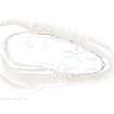
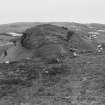
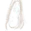
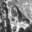
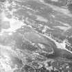
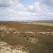
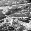
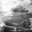
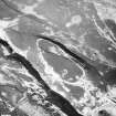
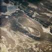
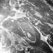
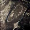
The Garrywhin fort occupies the summit of a broad-backed ridge, bounded on all but the N side by bogs, and is 590ft long by up to 200ft wide. Its single stone wall averages about 8ft in width and contains three entrances lined with large slabs of stone. A fourth (possible) entrance, halfway along the E wall, may have been, instead, the site of two chambers. There are ruins of some outbuildings outside the S entrance. RCAHMS 1911; R W Feachem 1963.
Garrywhin is generally as described above. The slabs at the N entrance are those published as 'Standing Stones', and the wall itself is now a mere tumble. The alleged E entrance has been utilised to form a crude rectangular yard. There is a small circular hollow, possibly a cistern, within the fort. There are definite traces of at least two outbuildings on a narrow terrace to the S of, and almost contiguous with the fort, but they are obscured by tumble from the fort. At the N side of one of the outbuildings there is a dry- stone aperture, roofed with a heavy lintel, and recessed into the hillside. The aperture measures 0.7m across, 0.5m high, and 0.8m deep. Its purpose is unknown.
Resurveyed at 1:2500.
Visited by OS (N K B) 21 April 1967.
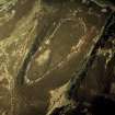
At ND 3123 4133 towards the S end of the fort are the remains of a probable hut circle partially exposed by recent heather burning. It survives as a barely perceptible platform about 7.5m in diameter, on the gentle S-facing hillslope bounded by a discontinuous band of rubble stones visible around the N, S and E sides, but obscured by peat on the W arc. No facing stones are visible, and the position of the entrance is uncertain.
Surveyed at 1:2500.
Visited by OS (N K B) 16 December 1976.
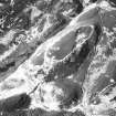
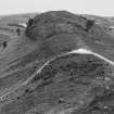
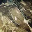
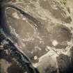
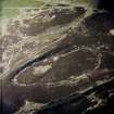
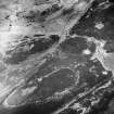
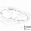
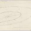
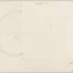
Garrywhin fort is defended by a single rampart, which follows the outer edge of a steep-sided ridge and encloses an area measuring 180m from NNE to SSW by 56m transversely at its broadest SSW end, narrowing to 35m at the NNE. The rampart measures 2.25m in thickness and still stands up to 1m in external height. Long stretches of outer wall-face survive to six courses, most notably in the SW quarter, where some of the stones appear to have been laid end-on into the body of the rampart. By contrast, the inner face is poorly defined, with only the occasional single facing-stone recorded in situ. On the WNW an internal quarry scar is still visible. Two breaks in the rampart indicate the position of entrances. The first, in the SSW, is still used by the footpath up to the fort from the Cairn of Get (ND34SW 4) and is 3.3m broad and lined by edge-set stones. Far more impressive is the NNE entrance, where the rampart swells to almost 6m in thickness and accommodates three massive orthostats marking the inner and outer extent of the entrance passage; no trace now remains of a fourth orthostat that presumably stood on the SSW, inner, side of the passage. The orthostats are set at right angles to the axis of the passage, and the outer pair both stand 1.65m in height; that on the NNW measures 1.6m by 0.23m at ground-level and that on the NNE 1.06m by 0.3m. The surviving inner stone measures 1.27m by 0.23m and stands 1.6m in height.
The interior of the fort is covered in peat and heather, and in places the peat has shrunk and cracked. A number of features have been recorded here, some of which are natural erosion scars. Towards the NNE end, quarries have been dug and there is an area of shallow standing water. In the NW quarter, two possible cairns (described separately under ND34SW 56) seem to be no more than collections of loose stones and boulders. Within the southern half of the interior, a U-shaped band of stones, measuring 1.5m in thickness, lies on gently sloping ground, but its purpose is unknown.
On the ESE two later structures have been built along the line of the rampart. The southern (YARROWS04 414) is a crudely formed subrectangular pen. The stone for its wall has been robbed from the rampart, creating a 1.9m break in its line, which has been described previously as an entrance. The interior measures at least 4.1m by 1.9m and the wall still stands 0.5m in height in four courses. The second structure lies 17m to the NNE and has been built against the outer face of the rampart. It measures 2m by 1.4m within a low spread rubble wall 1m in thickness and up to 0.4m in height. Another crudely formed enclosure (YARROWS04 75) lies to the SW of the southern entrance to the fort, immediately below the rampart. Circular on plan, the enclosure measures 5.5m in diameter within a spread rubble wall 2.5m in thickness and no more than 0.3m in height.
To its rear, set into the slope on the SW, there is a square cell formed by bedrock on the W, two courses of walling on the E and roofed with a large lintel. The interior of the cell measures 0.83m in breadth by 0.38m in height and at least 0.65m in depth.
(YARROWS04 75-7, 413-4)
Visited by RCAHMS (ARG, ATW) 16 June 2004
Field Visit (20 October 1955)
This site was included within the RCAHMS Marginal Land Survey (1950-1962), an unpublished rescue project. Site descriptions, organised by county, are available to view online - see the searchable PDF in 'Digital Items'. These vary from short notes, to lengthy and full descriptions. Contemporary plane-table surveys and inked drawings, where available, can be viewed online in most cases - see 'Digital Images'. The original typecripts, notebooks and drawings can also be viewed in the RCAHMS search room.
Information from RCAHMS (GFG) 19 July 2013.
Measured Survey (30 June 2004)
RCAHMS surveyed the fort at Garrywhin on 30 June 2004 with plane table and self-reducing alidade at a scale of 1:500. The plan was later redrawn in vector graphics software, with illustrations produced at scales of 1:500 and 1:1000.
Note (19 February 2015 - 18 May 2016)
This fort occupies a relatively low but steep sided ridge in the moorland to the W of Ulbster, which rises in a series of such ridges to the larger bulk of Warehouse Hill. Oval on plan, it measures about 180m from NNE to SSW by 55m transversely (0.85ha) within a single stone wall generally some 2.25m thick. Long stretches of the outer face are visible, in one place standing up to 1m in high in six courses. There are entrances on the SSW and NNE, the former 3.3m wide and lined with slabs set on edge, and the latter framed by a remarkable setting of orthostats. Though only three remain, there were evidently four set in pairs to mark the inner and outer ends of the passage through the wall, which at this point swells to a thickness of 4.5m; standing at right-angles to the passage, these massive stones are each about 1.6m high. Other features of the wall noted in 1983 by Roger Mercer include a series of narrow built channels set transversely through the body of the wall (1985, 110-12, figs 69-70), though these have not been noted by other investigators; he also followed Alexander Curle (RCAHMS 1911, 165, no.528) in suggesting that a rectangular structure let into the wall on the E was possibly the remains of a blocked entrance, and interpretation not shared by other investigators, most recently of RCAHMS, who regard this as a later insertion. The peat covered interior is heather-grown, but two collections of stones that may be the remains of small cairns can be seen at the NNE end, where there is also evidence of shallow surface quarrying, while a stony bank defines a small enclosure within the SSW end. In addition to the structure already noted on the E, another small pen has been built against the wall on this side, and a third outside the circuit on the SSW.
Information from An Atlas of Hillforts of Great Britain and Ireland – 18 May 2016. Atlas of Hillforts SC2830

