
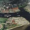
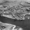
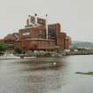
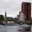
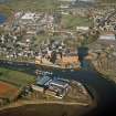
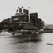
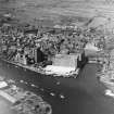
Dumbarton Distillery


Distillery (20th Century)
Site Name Dumbarton Distillery
Classification Distillery (20th Century)
Alternative Name(s) Inverleven Distillery; Allied Distillers; Ballantine's Scotch Whiskey Distillery; Castle Street
Canmore ID 90311
Site Number NS37NE 47
NGR NS 3978 7512
Datum OSGB36 - NGR
Permalink http://canmore.org.uk/site/90311


- Council West Dunbartonshire
- Parish Dumbarton
- Former Region Strathclyde
- Former District Dumbarton
- Former County Dunbartonshire
NS37NE 47.00 3978 7512
NS37NE 47.01 NS c. 397 750 Dumbarton, Shipyard
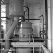
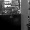
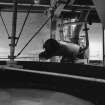
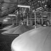
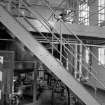
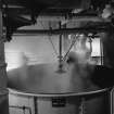
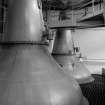
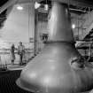
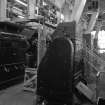
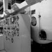
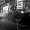
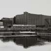
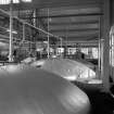
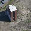
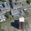
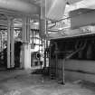
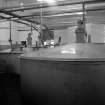
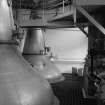
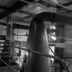
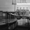
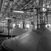
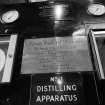
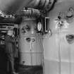
This distillery was built by Hiram Walker and Sons (Scotland) Ltd and has one Continuous Distilling Unit designed by a firm in Cincinatti, Ohio in 1938. The Dark Grains plant was the first in Scotland. Inverleven Malt Distillery is in the same complex and is licensed.
M S Moss and J R Hume 1981
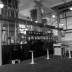
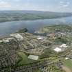
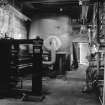
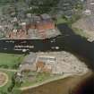
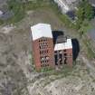
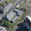
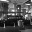
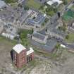
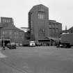
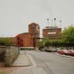
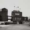
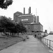
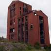
NS 398 751 A programme of historic building recording was undertaken in December 2004 and January 2005 in advance of the demolition of the 1930s buildings of Ballantine's Distillery (NS37NE 47.00) in Castle Street. These works were undertaken after the demolition of some of the buildings, and consisted of an external photographic and written record in addition to a brief photographic and written record of the interior of two of the buildings.
Archive to be deposited in NMRS.
Sponsor: Carvill Group Ltd.
D Sproat 2005
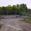
NS 397 751 An archaeological watching brief was carried out between September and November 2005 on the ground-breaking works associated with the redevelopment of the former Ballantine's Distillery at Castle Street, Dumbarton. No significant archaeological features or artefacts were encountered. Most of the area excavated revealed made ground of depths between 2.0m and 4.0m, with only small sporadic areas of natural alluvial material, mainly close to the NW edge of the site at depths of 2.0 m. This is the area of the development site closest to Riverside Parish Church and the historic core of Dumbarton, and the area of the site most likely to have archaeological features. The fact that no archaeological features were encountered here, only natural subsoil directly beneath modern made ground, indicates that any archaeological features that may have once been present have since been removed by modern construction, presumably associated with the former distillery.
Archive to be deposited in NMRS.
Sponsor: The Carvill Group.
V Clements 2006.
Watching Brief (September 2005 - November 2005)
NS 397 751 An archaeological watching brief was carried out between September and November 2005 on the ground-breaking works associated with the redevelopment of the former Ballantine's Distillery at Castle Street, Dumbarton. No significant archaeological features or artefacts were encountered. Most of the area excavated revealed made ground of depths between 2.0m and 4.0m, with only small sporadic areas of natural alluvial material, mainly close to the NW edge of the site at depths of 2.0 m. This is the area of the development site closest to Riverside Parish Church and the historic core of Dumbarton, and the area of the site most likely to have archaeological features. The fact that no archaeological features were encountered here, only natural subsoil directly beneath modern made ground, indicates that any archaeological features that may have once been present have since been removed by modern construction, presumably associated with the former distillery.
Archive to be deposited in NMRS.
Sponsor: The Carvill Group.
V Clements 2006

