
Following the launch of trove.scot in February 2025 we are now planning the retiral of some of our webservices. Canmore will be switched off on 24th June 2025. Information about the closure can be found on the HES website: Retiral of HES web services | Historic Environment Scotland
Tayport, Harbour


Crane (Period Unassigned), Harbour (19th Century)
Site Name Tayport, Harbour
Classification Crane (Period Unassigned), Harbour (19th Century)
Alternative Name(s) Old Harbour; River Tay; Tay Estuary; Firth Of Tay
Canmore ID 90049
Site Number NO42NE 75
NGR NO 45829 29098
Datum OSGB36 - NGR
Permalink http://canmore.org.uk/site/90049


- Council Fife
- Parish Ferry-port-on-craig
- Former Region Fife
- Former District North East Fife
- Former County Fife
NO42NE 75.00 45829 29098
Location formerly cited as centred NO 45829 29098.
NO42NE 75.01 4569 2919 Warehouse and Slipway
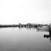
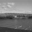
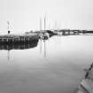
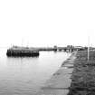
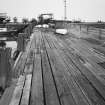
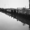
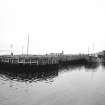
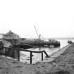
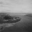
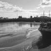
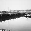
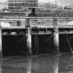
(Location cited as NO 459 291). Tayport Harbour, rebuilt 1847 by the Edinburgh & Northern Railway. Basin formed by a pier and two quays, built as terminus of the ferry to Broughty Ferry (qv).
J R Hume 1976.
Outer stone wall encloses inner harbour with quays to SE + W and on inner side of outer wall.
Site recorded by Maritime Fife during the Coastal Assessment Survey for Historic Scotland, Fife Ness to Newburgh 1996.
(originally entered under NMRS number NO42NW58, which has now been cancelled).
The area surrounding the harbour has been altered substantially since the 1970's. New housing has been built at the S end and W side of the harbour, the latter taking the site of the railway station (NO42NE 35). The basin has been modified with three pontoons for yachts to berth at and the outer pier is in use for boat repairs except the N end, which is now notified as having subsidence. There is little evidence of the extensive railway sidings or of the boat repair sheds that are shown on the historical OS maps. Two concrete clad slipways survive, one at the S end and one on the W side.
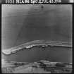
The harbour and surrounding area are visible on RAF WW II oblique aerial photographs (NLA 66, frames 0033-0046, flown 2 July 1943), which show the railway sidings and earlier buildings in the vicinity of the harbour.
Visited by RCAHMS (DE), 26 November 2008
Publication Account (2013)
TAYPORT HARBOUR
Rebuilt in 1847 to fit around a central pier that was used by the Edinburgh and Northern Railway RO-RO (roll on, rol off) transfer to Broughty Ferry until superseded by the Tay Bridge. The station and associated sheds have been demolished.
M Watson, 2013

