
Pricing Change
New pricing for orders of material from this site will come into place shortly. Charges for supply of digital images, digitisation on demand, prints and licensing will be altered.
Gote O'tram


Promontory Fort (Period Unassigned)
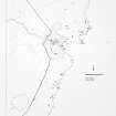
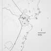
Site Name Gote O'tram
Classification Promontory Fort (Period Unassigned)
Alternative Name(s) Wic 180
Canmore ID 8958
Site Number ND34NE 5
NGR ND 3674 4796
Datum OSGB36 - NGR
Permalink http://canmore.org.uk/site/8958


- Council Highland
- Parish Wick
- Former Region Highland
- Former District Caithness
- Former County Caithness
ND34NE 5 3674 4796.
The remains of a fort at ND 3674 4796 (information from R G Lamb, Birmingham University). It consists of a ditch with inner rampart drawn across the neck of a cliff-girt promontory enclosing an irregular area measuring approximately 70.0m NW-SE by 40.0m trans- versely. The ditch, running N-S, appears to have been truncated in the N by erosion of the cliff, and is now only 7.0m long, 3.5m in width, and 1.5 deep, with natural rock showing in its W side, indicating that it may be partly rock-cut. Between it and the cliff in the S a gap 1.5m wide has been left, presumably for an entrance. The denuded earthen rampart on the inner lip of the ditch measures about 3.0m wide by 0.8m high. The interior is featureless.
Surveyed at 1:2500.
Visited by OS (I S S) 8 March 1972.
This promontory fort belongs to a class in which an apparently weak fortification protects a very restricted area. The landward approach to the ditch runs through a slight hollow beneath turf banks but this may be recent disturbance.
R G Lamb 1980.
The fort and defences are as described above.
Surveyed at 1:2500.
Visited by OS (J B) 2 September 1982.
Field Visit (8 March 1972)
The remains of a fort at ND 3674 4796 (information from R G Lamb, Birmingham University). It consists of a ditch with inner rampart drawn across the neck of a cliff-girt promontory enclosing an irregular area measuring approximately 70.0m NW-SE by 40.0m trans- versely. The ditch, running N-S, appears to have been truncated in the N by erosion of the cliff, and is now only 7.0m long, 3.5m in width, and 1.5 deep, with natural rock showing in its W side, indicating that it may be partly rock-cut. Between it and the cliff in the S a gap 1.5m wide has been left, presumably for an entrance. The denuded earthen rampart on the inner lip of the ditch measures about 3.0m wide by 0.8m high. The interior is featureless.
Surveyed at 1:2500.
Visited by OS (I S S) 8 March 1972.
Field Visit (1980)
This promontory fort belongs to a class in which an apparently weak fortification protects a very restricted area. The landward approach to the ditch runs through a slight hollow beneath turf banks but this may be recent disturbance.
R G Lamb 1980.
Field Visit (2 September 1982)
The fort and defences are as described above.
Surveyed at 1:2500.
Visited by OS (J B) 2 September 1982.
Note (18 February 2015 - 31 May 2016)
Access to this irregular promontory is barred at the narrow neck on the WNW by a rampart and external ditch. The rampart forms a bank 3m in thickness by 0.8m in height, and the ditch, which is no more than 7m in length, measures 3.5m in breadth by 1.5m in depth. A causeway has been left for the entrance on the SSW side of the neck. The interior, which measures maxima of 75m from ESE to WNW by 40m transversely (0.15ha), divides into two arms at right-angle to each other, with a heavily eroded cleft above the entrance to a sea cave in the angle between them on the NE; it is featureless.
Information from An Atlas of Hillforts of Great Britain and Ireland – 31 May 2016. Atlas of Hillforts SC2828

