
Pricing Change
New pricing for orders of material from this site will come into place shortly. Charges for supply of digital images, digitisation on demand, prints and licensing will be altered.
Bute, Butt A' Croit


Building (Period Unassigned), Enclosure(S) (Period Unassigned), Smallholding (Period Unassigned)
Site Name Bute, Butt A' Croit
Classification Building (Period Unassigned), Enclosure(S) (Period Unassigned), Smallholding (Period Unassigned)
Alternative Name(s) Tighnacruit, Teniecroit, Bullacroit, Buttacroit', Butt A Chruit, Balnakeilly Butt, Glenmore
Canmore ID 88736
Site Number NS07SW 38
NGR NS 02128 70869
Datum OSGB36 - NGR
Permalink http://canmore.org.uk/site/88736


- Council Argyll And Bute
- Parish North Bute
- Former Region Strathclyde
- Former District Argyll And Bute
- Former County Buteshire
NS07SW 38 02128 70869.
see also NS07SW 23
(NS 022 709.) Survey of deserted settlements, Isle of Bute: All sites are being measured and photographed, although a considerable number have still to be visited. To maintain uniformity a record form is completed for each site, with a brief description, including an indication of the reliability of the information. Air photographs (courtesy NMRS) have been used to locate many sites. Others have been identified only on early maps, (courtesy the Bute Estate Office). Research of documentary records, such as the Statute Labour Lists, Hearth Tax, Census Data, has generated considerable additional information, including family names, date of foundation or desertion. Information is uneven, because records are not equally available for all areas.
The majority of the settlements are post-medieval farm sites. Of several anomalous remains, some are earlier, while others, because of location and form are unlikely to be domestic structures.
The records are held in the Bute Museum, The basic list has been forwarded to NMRS.
Sponsors: Bute Antiq Natur Hist Soc; St Andrews Heritage Services.
Hannah and Proudfoot 1994.
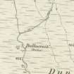
A single unroofed building which may be part of this site (see NS07SW 23) is depicted on the 1st edition of the OS 6-inch map (Argyllshire 1873, sheet cxciv), but it is not shown on the current edition of the OS 1:10000 map (1979).
Information from RCAHMS (AKK) 22 October 1998
NS 0213 7087 Site 168 Butt a chruit
This butt at the southern extremity of Balnakeilly lies only 100m from Achavoulig Butt (NS07SW 23), and the two sites might have been supposed, on the basis of field survey alone, to have formed a single township. In fact the present site was a butt of Balnakeilly, and seems to have been abandoned c1770. Wall footings of a house and two yards survive, as well as a field of rig and furrow to the north of the site. The sycamore tree growing on the yard wall is a conspicuous landmark.
Proudfoot and Hannah 2000
NS 0213 7087 Settlement remains: Located in upper Glenmore beside small tributary on E side of main burn, 120m from Achavoulig Butt. The remains of 1 house aligned down-slope, with 2 small adjacent enclosures and traces of other structures. A butt of Balnakailly
Information from Bute Natural History Society Deserted Settlement Survey (1991-9)
(RCAHMS WP000273)
This smallholding, which comprises a building, two enclosures and cultivation remains, is situated in moorland 110m NE of Achavoulaig Butt (NS07SW 23), on the N bank of an un-named tributary of the Glenmore Burn. The drystone building measures about 10m from ENE to WSW by 5.5m transversely over walls reduced to heaps of rubble. There is an entrance in the middle of the NNW side and a later pen has been built within the NE corner. Two enclosures, the walls of each reduced to grass-grown rubble, are situated immediately NE and SW, and rig-and-furrow is visible to the SE.
The settlement is depicted on a mid-18th century estate map (Foulis 1758-9), which shows a building and an enclosure at the southernmost end of the lands of Balnakailly (NS07SW 29). The smallholding is also depicted on Mackinlay's map of North Bute (1823), but it appears to have been abandoned by the 1860s as the building is shown roofless on the 1st edition of the OS 6-inch map (Argyllshire and Buteshire 1869, Sheet CXCIII).
Visited by RCAHMS (GFG, ARG) 18 March 2009.
Antiquarian Mapping (1758 - 1759)
Antiquarian Mapping (1823)
Field Visit (1991 - 1999)
NS 0213 7087 Settlement remains: Located in upper Glenmore beside small tributary on E side of main burn, 120m from Achavoulig Butt. The remains of 1 house aligned down-slope, with 2 small adjacent enclosures and traces of other structures. A butt of Balnakailly
Information from Bute Natural History Society Deserted Settlement Survey (1991-9)
(RCAHMS WP000273)
Field Visit (18 March 2009)
This remains of this smallholding, which comprise a building, two enclosures and cultivation remains, are situated in rough ground on the N side of a tributary into the Glenmore Burn, 125m NE of Achavoulaig Butt (NS07SW 23). The single drystone building is generally as described by previous authorities, with its entrance to the NW and a later pen in the N corner. There are turf walled enclosures to the NE and SW and cultivation remains to the SE. A Foulis estate map (1758-9) depicts a single building and a yard in this position, at the extreme S of the lands of Balnakailly farmstead (NS07SW 29). The building and yards are also depicted on Mackinlay's map of 1823.
Visited by RCAHMS (GFG, ARG) 18 March 2009.
Measured Survey (29 September 2010)
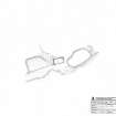
RCAHMS surveyed the building, enclosure and smallholding at Butt a' Croit, Bute on 29 September 2010 with local volunteers. The survey, undertaken using plane table and alidade, produced a plan of the site at a scale of 1:250.

