
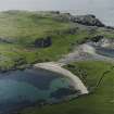
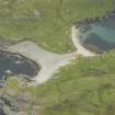
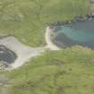
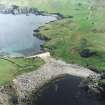
Fethaland


Roundhouse (Prehistoric)
Site Name Fethaland
Classification Roundhouse (Prehistoric)
Alternative Name(s) Fedeland; Isle Of Fethaland
Canmore ID 876
Site Number HU39SE 1
NGR HU 37527 94301
Datum OSGB36 - NGR
Permalink http://canmore.org.uk/site/876


- Council Shetland Islands
- Parish Northmavine
- Former Region Shetland Islands Area
- Former District Shetland
- Former County Shetland
HU39SE 1 3753 9429.
(HU 3751 9432) A mound about 5' high, with the appearance of a ruined broch, was excavated under Abercromby's direction in June 1904, and found to be a chambered structure, standing only a few inches above the natural surface.
Finds included sherds of hand-made pottery containing much mica, are of the pieces showing a flat bottom.
J Abercromby 1905
Classing this site as a probable broch RCAHMS admit that 'most of Abercromby's constructional details clearly belong to structures of secondary character' but go on to state - 'Nowadays the larger part of what Abercromby saw has been destroyed, but it is possible still to trace the arc of the semi-circular wall shown on his plan in the interior of the structure at 'A' and 'B'. It might be claimed that this may possibly represent the foundation course of the inner face of a broch wall but in the absence of any definite masonry above, no more positive identification can be made'.
RCAHMS 1946, visited 1931
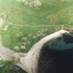
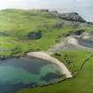
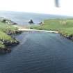
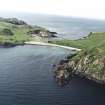
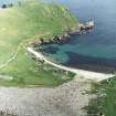
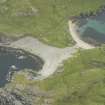
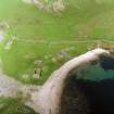
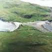
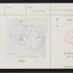
At HU 3752 9432, are the remains of a chambered structure, oval on plan, measuring overall approximately 20.0m E to W by 15.5m transversely. The walling appears to be c.3.0 m thick but only the inner face is evident on the N and E arc. A number of upright slabs and internal walls indicate the remains of cells or chambers and the site gives the appearance of a domestic dwelling. This is clearly not a broch, and is probably an Iron Age round-house of Calf of Eday type.
Surveyed at 6" scale.
Visited by OS (RL) 17 May 1969
Scheduled with HU39SE 19 as Fedeland, fishing station and prehistoric house.
Information from Historic Scotland, scheduling document dated 10 October 1994.
Field Visit (9 August 1931)
Broch (probable), Fethaland.
The scattered remains that are still to be seen on the so-called "Isle of Fethaland," just beyond and NE of the neck which connects the peninsula with the mainland, are noted on the O.S. map as those of a broch, and for many years they have been locally so regarded. The site is not, however, included in the list of Shetland brochs supplied in 1871 to Anderson by Russell (1), nor do the remains appear to have been unequivocally accepted as those of a broch by Lord Abercromby, who investigated and planned the existing structure in 1904. He says: "This mound, about 5 feet high at the most, had the appearance of a very much ruined broch, or analogous structure." (2). The plan which he reproduced (Fig. 603) shows little indication of broch-like outline. Indeed, no evidence of an outer wall-face can be traced nor can any wall thickness of broch-like dimensions be determined. There are, moreover, no traces of any adjacent "out-buildings" or surrounding defensive works. The absence of such distinguishing features, however, might be explained by the fact that the structure and its surroundings had been extensively quarried to provide building materials for the now deserted huts or ‘lodges’, once used for the ‘haaf’ or deep sea fishing.
Abercromby's plan shows an irregularly shaped structure which he describes as "far from circular." "Its greatest length," he says, "measures 49 feet and its greatest width 37 feet. At A on the plan there is a slightly curved chamber 11 feet long by 3 ¼ feet wide, with an entrance 3 ½ feet in breadth. At the west end of the chamber is a step about 3 inches higher than the rest of the floor. At B there are also remains of a curved chamber 6 feet by 3 ¼ feet. nearly closed at the south end by an upright slab 3 feet long. Between the outer edge of the slab and the inside of the outer wall is 10 inches. At C there seemed to be the remains of a beehive hut, as the walls on the north side, which are still 3 feet 4 inches high, are not vertical, but project a little forwards. The large stone to the right of C is 2 feet 2 inches long and3 feet high ....
"The recess D, which seems to have been used as a fireplace, as quantities of ashes were found there, is formed by three slabs; that to the north is 31 inches high, that to the west 34 inches high, and that to the south only 18 inches in height. Its prolongation westwards, marked F, shows a row of horizontally placed slabs, extending for about 7 feet, and about 21 feet wide. They look like the roof of a drain or narrow passage. . .. At E there is a rectangular depression 6 ½ feet by 4 feet; on the north side the height of the wall is 34 inches, and on the east 30 inches.
"Close to the north-west corner of the structure is a paved road, or perhaps the foundation of a wall, 5 feet wide, leading due north. . . . The present entrance is about 4 feet wide, but this is the most dilapidated part of the ruins ... ." It "leads straight to a rectangular foundation of modern date".
Most of these constructional details clearly belong to structures of secondary character, the entrance above mentioned, for example, having no resemblance to that of a typical broch. Nowadays the larger part of what Abercromby saw has been destroyed, but it is possible still to trace the arc of the semicircular wall shown on his plan in the interior of the structure at A and B. It might be claimed that this may possibly represent the foundation course of the inner face of a broch wall but, in the absence of any definite masonry above, no more positive identification can be made.
The relics found during the 1904 examination do not, in any respect, help towards a definite identification. They were "all more or less fragmentary and of no special interest". Few can be described as characteristic broch relics.
RCAHMS 1946, visited 9 August 1931.
(1) Russell's broch at "Fedeland" (Arch. Scot., v, p. 180) can be identified with the remains at the Kame of Isbister (HU39SE 4).
(2) PSAS, xxxix (1904-5), p. 171.
(3) Ibid., pp. 172-3.
(4) Ibid., p. 174.
Publication Account (2002)
HU39 1 FETHALAND ('Easter Wick')
HU/375943
Possible broch in Northmavine. A structure exists there and was partially dug out and planned in 1904 [4]. It bears little resemblance to a broch except in what may be two curved, rectangular wall chambers which seem to lie on the circumference of a circle about 30 ft. in diameter, rather small for a broch [2, fig. 603]; the site has been extensively quarried. More of it had been destroyed by 1931 [2].
A list of the finds made in 1904 includes nothing specifically of broch type [4, 174].
Sources: OS card HU 36 NW 10: 2. RCAHMS 1946, vol. 3, no. 1355, 91 and fig. 603: 3. C. S. T. Calder in Discovery and Excavation, Scotland, 1956, 28: 4. Lord Abercromby in P.S.A.S., 39 (1904-5), 171.
E W MacKie 2002
The RCAHMS reference for this site is HU39SE 1.
Information from RCAHMS (LMcC) 17 July 2009
Field Visit (30 August 2015)
Found as described.
Visited by Scotland's Coastal Heritage at Risk (SCHARP) 30 August 2015
Field Visit
A well-defined sub-circular stone structure is partially covered with coarse vegetation. Overall, it measures 12m in diameter. The outer wall stands up to 1m high and is at least 2.2m, increasing at the entrance to form an elongated entrance passage. The passage is 7.5m long and is flanked by intermittent large orthostats. This leads to a dished central area, 5.5m in diameter. Intermittent stone settings indicate internal divisions and features. The site was partially excavated early this century (Abercromby, 1905); the site plan appears to show a collection of secondary structures built over a large round house. While undoubtedly much disturbed, it would appear that neither excavation or stone robbing have yet uncovered the primary deposits at this site. Its location, on a narrow isthmus, suggests that this structure played a strategic role, although it does not appear to have had outer defences. Its size and shape indicate that it is not a true broch, but may be a house of contemporary date which incorporates elements of broch architecture. The suggestion of an outer ditch is indicated on aerial photographs (RAF neg.4140, 541 (A)/390, 18.5.48).
Visited by Scotland's Coastal Heritage at Risk (SCHARP)

