
Dalchulag


Farmstead (Post Medieval), Kiln (Post Medieval)(Possible)
Site Name Dalchulag
Classification Farmstead (Post Medieval), Kiln (Post Medieval)(Possible)
Alternative Name(s) Drumour; Dalhalleck; Dallhalleck
Canmore ID 86471
Site Number NN93NE 29
NGR NN 9661 3945
NGR Description centred on NN 966 394
Datum OSGB36 - NGR
Permalink http://canmore.org.uk/site/86471


- Council Perth And Kinross
- Parish Little Dunkeld
- Former Region Tayside
- Former District Perth And Kinross
- Former County Perthshire
Field Visit (8 September 1993)
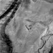
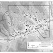
NN93NE 29 centred on 966 394
The remains of this farmstead, surrounded by recently-planted conifers, stand on the summit of a knoll above the S bank of the River Braan, about 700m upstream of Drumour Bridge. There are three buildings, grouped around a yard. They all have faced rubble walls up to 0.7m thick within which several cruck-slots can be identified; the side walls stand up to 1.5m in height and some of the gable ends remain intact. The principal building appears to have been that on the NW side of the yard (Braan93 23), which measures internally 10.2m from ENE to WSW by 3.9m transversely, with a two-compartment extension, 10.1m long, added at the WSW end. There is a fireplace in the WSW end gable of the original portion. The SW side of the yard is defined by a building measuring internally 10.4m from SE to NW by 3.8m transversely (Braan93 22); it has two compartments, each with an entrance opening onto the yard. Both of these buildings have been reused for folding sheep since their abandonment: doors have been blocked, part of the SSE wall of the NW building has been rebuilt, and an enclosure has been inserted in the angle between them. The third building (Braan93 24) stands at the E corner of the yard. Aligned NW-SE, it measures internally 6.6m in length and 3.1m in breadth, with an outshot 4.1m in length attached to its NW end. Both the main portion and the outshot have entrances on the NE side, and there is a window in the SW wall of the outshot.
All three buildings are depicted, roofless, on the 1st edition of the OS 6-inch map (Perthshire 1867, sheet lxi) and the site is named 'Dalchulag'. The map also shows what appears to be a roofless building (NN93NE 30) by the side of a burn 110m away to the WSW, and an enclosure (NN93NE 31) at the top of a scarp 90m to the NW, but neither of these features was located in the now afforested ground.
(Braan93 22-4)
Visited by RCAHMS (SDB) 8 September 1993

