|
Manuscripts |
MS 731/13 |
Records of the Royal Commission on the Ancient and Historical Monuments of Scotland (RCAHMS), Edinbu |
Printout of Afforestable Land Survey field database (Strathbraan survey) |
1993 |
Item Level |
|
|
Photographs and Off-line Digital Images |
C 6479 |
RCAHMS Aerial Photography |
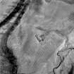
Aerial view of Dalchulag farmstead, building and enclosure. |
1993 |
Item Level |
|
|
Photographs and Off-line Digital Images |
C 6480 |
RCAHMS Aerial Photography |
Oblique aerial view. |
1993 |
Item Level |
|
|
Photographs and Off-line Digital Images |
C 6481 |
RCAHMS Aerial Photography |
Oblique aerial view. |
1993 |
Item Level |
|
|
Photographs and Off-line Digital Images |
C 6482 |
RCAHMS Aerial Photography |
Oblique aerial view. |
1993 |
Item Level |
|
|
Photographs and Off-line Digital Images |
C 6485 |
RCAHMS Aerial Photography |
Oblique aerial view. |
1993 |
Item Level |
|
|
Prints and Drawings |
DC 37330 PO |
Records of the Royal Commission on the Ancient and Historical Monuments of Scotland (RCAHMS), Edinbu |
Distribution map of medieval and later settlement. Generated from RCAHMS computer file DC37330ai. |
1996 |
Item Level |
|
|
Photographs and Off-line Digital Images |
PT 9821 |
|
Dalhalleck, no.2
General view from East. |
c. 1960 |
Item Level |
|
|
Photographs and Off-line Digital Images |
PT 9822 |
|
Dalhalleck, nos.3, 4, 5
View of building 5 across courtyard from West. |
c. 1960 |
Item Level |
|
|
Photographs and Off-line Digital Images |
PT 9823 |
|
Dalhalleck, nos.6, 7, 8
View of building 4 from West. |
c. 1960 |
Item Level |
|
|
Photographs and Off-line Digital Images |
PT 9824 |
|
Dalhalleck, nos.3, 4
View of buildings 3 and 4. |
c. 1960 |
Item Level |
|
|
Photographs and Off-line Digital Images |
PT 9825 |
|
Dalhalleck, no. 3.
View of drain and cruck slot of building 3 from North. |
c. 1960 |
Item Level |
|
|
Photographs and Off-line Digital Images |
PT 9826 |
|
Dalhalleck, nos. 2, 3.
View nos. 2 and 3 including West gable. |
c. 1960 |
Item Level |
|
|
Photographs and Off-line Digital Images |
PT 9827 |
|
Dalhalleck, nos. 1, 2.
View of nos 1 and 2 from North East. |
c. 1960 |
Item Level |
|
|
Photographs and Off-line Digital Images |
PT 9828 |
|
Dalhalleck, nos. 1- 5.
View of 1-5 from South. |
c. 1960 |
Item Level |
|
|
Photographs and Off-line Digital Images |
PT 9829 |
|
Dalhalleck
View of ruins near stream to South-West of site East. |
c. 1960 |
Item Level |
|
|
Photographs and Off-line Digital Images |
PT 9830 |
|
Dalhalleck
General view from East. |
c. 1960 |
Item Level |
|
|
Photographs and Off-line Digital Images |
PT 9831 |
|
Dalhalleck
General view of ruins from enclosure from North East. |
c. 1960 |
Item Level |
|
|
Photographs and Off-line Digital Images |
PT 9832 |
|
Dalhalleck
View from East. |
c. 1960 |
Item Level |
|
|
Photographs and Off-line Digital Images |
PT 9833 |
|
Dalhalleck
View of building enclosure 2 and stream. |
c. 1960 |
Item Level |
|
|
Photographs and Off-line Digital Images |
PT 9834 |
|
Dalhalleck
View of building 3 from North-West. |
c. 1960 |
Item Level |
|
|
Prints and Drawings |
PTD 561/1 |
Perth Building Survey |
Dalhalleck, Strathbraan
Perth Building Survey, composite plan. |
1982 |
Item Level |
|
|
All Other |
PTR 202 |
Perth Building Survey |
Dalhalleck
Record sheet, Perth Building Survey. |
1983 |
Item Level |
|
 |
On-line Digital Images |
SC 695372 |
RCAHMS Aerial Photography |
Aerial view of Dalchulag farmstead, building and enclosure. Digital image of C/6479. |
1993 |
Item Level |
|


