
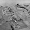
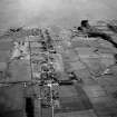
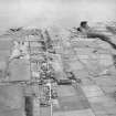
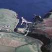
Lybster Harbour


Harbour (19th Century)
Site Name Lybster Harbour
Classification Harbour (19th Century)
Alternative Name(s) Invershore; Reisgill Burn; Lybster Pier; Lybster Bay
Canmore ID 8646
Site Number ND23SW 15
NGR ND 24466 34861
NGR Description Centred ND 24466 34861
Datum OSGB36 - NGR
Permalink http://canmore.org.uk/site/8646


- Council Highland
- Parish Latheron
- Former Region Highland
- Former District Caithness
- Former County Caithness
ND23SW 15.00 centred 24466 34861
Harbour [NAT]
OS 1:10,000 map, 1983.
ND23SW 15.01 ND 24504 34788 Beacon ('Lighthouse', on breakwater)
ND23SW 15.02 ND c. 244 348 Harbour Master's Office (with mural barometer)
See also:
ND23SW 17 ND 24395 34872 Warehouse
ND23SW 19 ND 2441 3498 Fish-smoking Kiln
ND23NW 102 ND 24415 35075 Weir
ND23NW 103 ND 24464 35005 Footbridge
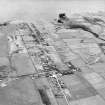
(Location cited as ND 245 349). Lybster Harbour. Built as a fishing harbour 1849, and rebuilt 1882 at the expense of the Duke of Portland. A complex harbour with four basins. The quay walls have recently been sheet-piled. At the entrance is a small octagonal lighthouse, with a domed lantern. There are two storehouses, one of them three-storey and six-bay, the other two-storey and six-bay; upstream are the ruins of a two-storey, four-bay store, and of a mill.
J R Hume 1977.
(Location cited as ND 245 350). Lybster: in 1817 the British Fisheries Society organised Lybster fishing station, working forty boats, and including Forse, Achastle, Swiney and Clyth. By 1833 this station was the third largest in all Scotland. W G Mowat, the local historian whose account is followed throughout this note, adduces place name evidence for Early Christian and Viking use of the landing place at the mouth of the Reisgill Burn in Lybster Bay, and leads up to its development at the height of the herring fishing boom by recording that clearance victims were fishing here for lobsters in 1793. The improving proprietor, General Patrick Sinclair of Lybster, founded the village (ND23NW 30) in 1802, and began to grow wheat in 1806. He built a timber pier in 1810.
In 1830, the harbour was formed by the erection of a stone pier 90yds (82.2m) long, paid for wholly by the proprietor, Captain T F Sinclair. Mowat dates the completion of this pier in 1832, and states that it ran along the W bank of the Reisgill [Burn] to the sea, and that a stone jetty with an adjoining retaining wall and an upper retaining wall was built on the E side of the harbour mouth in the same year. Boats at that time were beached or moored to rings in the rocks near the Reisgill waterfall [presumably the weir at ND 24421 35071]. In 1833, Inver House, then an inn, was built into the face of the hillside above the right bank of the burn, which was diverted from crossing the building site into its present course. This is as already shown on the Admiralty Survey made by Slater and Calver in 1839. Their plan, published by the Tidal Harbours Commissioners in 1847, shows an area of the burn mouth inside both piers largely dried out at low tide, and illustrated the need for deepening alluded to in the New Statistical Account. After a gale in 1848, in which 94 Caithness fishermen were drowned, the Washington commission issued a preliminary account from the main Report recommending improvement of the 'small but safe harbour of Lybster' with an urgency in strong contrast to the tone of the recommendations for Wick (ND35SE 66.00) which emerged after a long enquiry. Work financed by the resulting Parliamentary grant enabled Lybster to shelter 100 boats. J Mitchell, the Fishery Commissioners' engineer, supervised work by a Perth contractor to the designs of D Stephenson. Improvements continued after 1850, causing riots when construction stopped fishing, and left the harbour much as is it today, apart from internal N and E jetties. The weir in the Reisgill [at ND 24421 3507], specially recommended by Washington, was made at this time.
Structure
The site of General Sinclair's wooden pier of 1810 is perhaps most likely to have been the same as that of the stone jetty of 1832 on the E bank, as this is sheltered from the N and E, and would, before the long W bank extension pier was run out to below low water mark opposite, have been directly at the burn mouth. The lozenge-shaped head of the pier now occupying this site is built of large rough blocks, in the surface of which one stone pawl survives. A slip rises behind rocks to the SE up to the level of the former fish-curing buildings [presumably ND23SW 19]. The form of the retaining walls running inland along the left bank shows little change from the plan of 1839 in spite of modern resurfacing and additions. Four sets of steps in the shore wall, and three in the land-retaining wall recall the heightened activity of transferring herring from a harbour full of boats to the curing stations [presumably ND23SW 19] above, between tides. The shoreward end and W side of the harbour show fewer early features. There is still a slip in the centre of the shoreward end. This served a boatyard, which replaced the curing ground shown there in 1839. The enlarged basin of the 1850's brought a new approach road to the back of its new quays, adjoining the improved and straightened 90yd (82.2m) pier, which still occupies the site of the 1832 original.
A Graham and J Gordon 1988.
The harbour at Lybster was began as a stone quay along the west bank of the mouth of the Reisgill Burn. Much enlarged by Joseph Mitchell in 1850-4 and again in 1883-5.
J Gifford 1992.
During April 1999, RCAHMS conducted a photographic survey of the standing industrial heritage remaining in Lybster. The purpose of this survey was to enhance and augment the existing holdings of the National Monuments Record Scotland.
Visited by RCAHMS (MKO), July 1998.
The location assigned to this record is essentially tentative. Lybster harbour (ND23SW 15) is centred at ND 2446 3490 and extends from ND 2446 3499 to ND 2452 3478.
Information from RCAHMS (RJCM), 6 January 2011.
Construction (1810)
A wooden pier was constructed in 1810 after founding of village in 1802.
R Paxton and J Shipway, 2007.
Modification (1832)
A stone pier was built in 1832 along west bak of the Reisgill to the sea. A stone jetty with retaining wall on the east side of the harbour wall was also built the same year.
R Paxton and J Shipway, 2007
Modification (1852)
The harbour was improved c. 1852 to accommodate 100 boats.
R Paxton and J Shipway, 2007.
Publication Account (2007)
Lybster Harbour
(Institute Civil Engineers Historic Engineering Works no. HEW 0404)
Telford, in a report to the British Fisheries Society in 1790, recommended a small improvement to the natural safe harbour at Lybster, but it was not until 1802 that the village was founded. A timber pier was built in 1810 by General P. Sinclair which was probably replaced by a 90 yard stone pier in 1832. It ran south along the west bank of the Reisgill to the sea. A stone jetty with an adjoining retaining wall was also built on the east side of the harbour mouth in 1832.
After a gale in 1848, in which 94 Caithness fishermen were drowned, the harbour was improved by ca.1852 to accommodate 100 boats, basically to its present form. The contractor was Christopher Moses of Perth under the supervision of Joseph Mitchell, the Fishery Board Commissioners’ engineer, a post taken up by D. & T. Stevenson on Mitchell’s retirement in 1851. The harbour is also notable as being the location, with a maximum fetch of 600 miles, where the heights of waves were first systematically measured by Thomas Stevenson. The results showed November–February as the period of highest waves with 1312 ft being attained.
R Paxton and J Shipway, 2007.
Reproduced from 'Civil Engineering heritage: Scotland - Highlands and Islands' with kind permission from Thomas Telford Publishers.
Note (July 2013)
Lybster Harbour underwent modification between 1871 (see 1st edition Ordnance Survey 25-inch map (Caithness 1877 (surveyed 1871), sheet XXXIII.16)) and 1906, by which time the harbour had been extended in its north-west corner (see 2nd edition Ordnance Survey 25-inch map (Caithness-shire 1906 (revised 1905), sheet 033.16)) to increase capacity. Two piers have since been inserted into the harbour basin at its south-west corner.
Information from RCAHMS (MMD) 23 July 2013.

