
Following the launch of trove.scot in February 2025 we are now planning the retiral of some of our webservices. Canmore will be switched off on 24th June 2025. Information about the closure can be found on the HES website: Retiral of HES web services | Historic Environment Scotland
Tarbrax


Rig And Furrow (Medieval) - (Post Medieval), Village (19th Century) - (20th Century)
Site Name Tarbrax
Classification Rig And Furrow (Medieval) - (Post Medieval), Village (19th Century) - (20th Century)
Alternative Name(s) Tarbrax, Shale-oil Works
Canmore ID 85574
Site Number NT05NW 10.01
NGR NT 0270 5520
NGR Description Centred NT 0270 5520
Datum OSGB36 - NGR
Permalink http://canmore.org.uk/site/85574


- Council South Lanarkshire
- Parish Carnwath
- Former Region Strathclyde
- Former District Clydesdale
- Former County Lanarkshire
NT05NW 10.01 centred 0270 5520
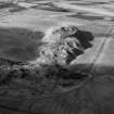
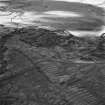
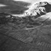
(Location cited as NT 026 552). Tarbrax Village, built 1904 for the Tarbrax Oil Co. A group of rows of single-storey shaleworkers' cottages. The shale-bing, all that is left of the oil works here, is being removed for hard-core.
J R Hume 1976.
Field Visit (July 1994)
NT05NW 10.01 centred 0270 5520
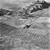
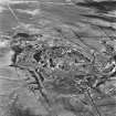
The village of Tarbrax is today around half the size of that depicted on the revised edition of the OS 6-inch map (Lanarkshire 1911, sheet xv). It is situated immediately to the S of the shale-oil works (NT05NW 10.00). Apart from the occupied rows of houses on the E, there are the fragmentary remains of nine workers rows to the W of the maiden Burn (CSW 4707). Nothing now remains of the further rows to the S (CSW 4709) around the 'Lazy Y' public house.
Originally constructed to house the workers for for the Tarbrax Oil Company which closed in 1925, the houses continued in use for the workers of various mines in the area until they too closed down. The present population occupies the rows on the E, and the additional detached houses to the E of the road to Carnwath which have mostly been built since 1910.
(CSW 4707, 4709, 4713)
Visited by RCAHMS (DCC) 15, 20 July 1994
Aerial Photographic Interpretation (January 1997)
The present village is visible on vertical air photograph (OS 70/367/013, flown 1970), along with the remains of the large shale bing and associated shale works.
Information from RCAHMS (DE) January 1997
Aerial Photographic Interpretation (17 September 1998)
Oblique aerial photography has identified an area of rig and furrow cultivation in the field immediately to the E of the houses on Viewfield Road, centred on NT 0290 5521.
Information from RCAHMS (KB) 17 September 1998

