
Dalmore Farm


Pit(S) (Period Unassigned), Settlement (Period Unassigned)
Site Name Dalmore Farm
Classification Pit(S) (Period Unassigned), Settlement (Period Unassigned)
Canmore ID 85363
Site Number NH66NE 49
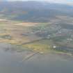
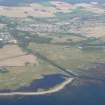
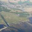
NGR NH 666 690
Datum OSGB36 - NGR
Permalink http://canmore.org.uk/site/85363


- Council Highland
- Parish Rosskeen
- Former Region Highland
- Former District Ross And Cromarty
- Former County Ross And Cromarty
NH66NE 49 666 690
In an area centred here probable Iron Age settlement was found. The features included post holes from a probable roundhouse, a circular building 8m in diameter with posts c. 100 mm in diameter, two grain storage pits with c. 5 kg of carbonised grain as well as another possible building and an area of iron working represented by hammer scale. Recorded during archaeological supervision of the topsoil strip for the Dingwall-Invergordon British Gas pipeline.
Sponsor: British Gas.
J Wordsworth 1993.

