
Glen Fender


Building(S) (Post Medieval), Field System (Medieval) - (Post Medieval), Lade (Post Medieval), Rig And Furrow (Medieval) - (Post Medieval)
Site Name Glen Fender
Classification Building(S) (Post Medieval), Field System (Medieval) - (Post Medieval), Lade (Post Medieval), Rig And Furrow (Medieval) - (Post Medieval)
Canmore ID 84880
Site Number NN93NW 13.14
NGR NN 90 38
NGR Description centred on NN 90 38
Datum OSGB36 - NGR
Permalink http://canmore.org.uk/site/84880


- Council Perth And Kinross
- Parish Little Dunkeld
- Former Region Tayside
- Former District Perth And Kinross
- Former County Perthshire
Field Visit (8 December 1993)
NN93NW 13.14 centred on 90 38
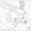
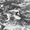
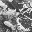
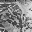
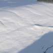
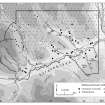
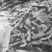
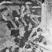
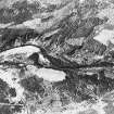
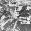
On the N side of the deeply-incised valley of the Glenfender Burn there is a gently-shelving, largely grass-covered, terrace. The terrace, and parts of the steeper, heather-covered, ground have been enclosed by earth-and-stone banks to form a series of oval and sub-rectangular fields of at least two phases. The more recent phase of the field-system occupies the flatter ground on the terrace, and is characterised by fields measuring up to 200m by 120m, and containing fragments of rig. Improvement has fragmented the field-system between the Crieff to Dalnacardoch military road (NN93NW 14) and Innercochill. The military road cuts across at least one of the field banks and runs diagonally across a field. Some of the fields are sub-divided by banks laid out across the contour and contain scattered heaps of field clearance.
The large fields truncate a series of smaller, oval and sub-rectangular, plots lying on the steeper, more broken, ground at the back of the terrace. Rig is not visible in these plots but this may have been due to the rank heather which covered most of them. Within some of the plots, however, there are lynchets, running along the contour, which suggest that the plots have been cultivated. Cutting across the plots, and running roughly WNW-ESE, there is a lade measuring about 1.5m across and up to 1m in depth. The lade disappears in the improved ground to the WNW of Innercochill and appears to respect the larger fields of the terrace below. To the N of the lade, a deeply-cut hollow trackway runs up Glen Fender, respecting both sets of fields.
Within the field-systems described above there is a scatter of seven sub-rectangular buildings (Braan93 399, 413-418) measuring up to 10.4m by 3.8m (NN 9046 3869; Braan93 415) within faced-rubble footings spread to 1.5m in thickness and 0.5m in height. Where visible, the entrance is in the side wall. One of the buildings (Braan93 416) is cut by a lade.
(Braan93 399, 413-418)
Visited by RCAHMS (DCC) 8 December 1993
Note (4 February 1998)
The field-system is depicted on the 1st edition of the OS 6-inch map (Perthshire 1867, sheet lxxi), but only part shown on the current edition of the OS 1:10000 map (1982).
Information from RCAHMS (AKK) 4 February 1998.

