|
Manuscripts |
MS 731/13 |
Records of the Royal Commission on the Ancient and Historical Monuments of Scotland (RCAHMS), Edinbu |
Printout of Afforestable Land Survey field database (Strathbraan survey) |
1993 |
Item Level |
|
|
Prints and Drawings |
DC 27573 PO |
|
Plan of archaeological landscape (generated from digital files) |
1995 |
Item Level |
|
|
Photographs and Off-line Digital Images |
C 12427 |
RCAHMS Aerial Photography |
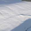
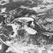
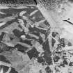
Oblique aerial view. |
1993 |
Item Level |
|
|
Photographs and Off-line Digital Images |
C 12433 |
RCAHMS Aerial Photography |
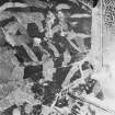
Oblique aerial view. |
1993 |
Item Level |
|
|
Photographs and Off-line Digital Images |
C 12428 |
RCAHMS Aerial Photography |
Oblique aerial view. |
1993 |
Item Level |
|
|
Photographs and Off-line Digital Images |
C 12432 |
RCAHMS Aerial Photography |
Oblique aerial view. |
1993 |
Item Level |
|
|
Prints and Drawings |
DC 37330 PO |
Records of the Royal Commission on the Ancient and Historical Monuments of Scotland (RCAHMS), Edinbu |
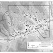
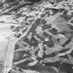
Distribution map of medieval and later settlement. Generated from RCAHMS computer file DC37330ai. |
1996 |
Item Level |
|
|
Prints and Drawings |
DC 37333 PO |
Records of the Royal Commission on the Ancient and Historical Monuments of Scotland (RCAHMS), Edinbu |
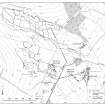
Plan of archaeological landscape. Generated form digital file DC37333.tif. |
1996 |
Item Level |
|
|
Photographs and Off-line Digital Images |
C 56291 |
RCAHMS Aerial Photography |
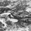
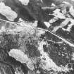
Glen Fender, oblique aerial view, taken from the NE, centred on a hut-circle. The Crieff to Dalnacardoch militray road is visible in the left half of the photograph. |
6/6/1996 |
Item Level |
|
|
Photographs and Off-line Digital Images |
C 56292 |
RCAHMS Aerial Photography |
Glen Fender, oblique aerial view, taken from the W, centred on a hut-circle. The Crieff to Dalnacardoch military road is visible in the right half of the photograph. |
6/6/1996 |
Item Level |
|
|
Photographs and Off-line Digital Images |
C 56293 |
RCAHMS Aerial Photography |
Glen Fender, oblique aerial view, taken from the SW, centred on a hut-circle. The Crieff to Dalnacardoch military road is visible in the right half of the photograph. |
6/6/1996 |
Item Level |
|
|
Photographs and Off-line Digital Images |
C 56294 |
RCAHMS Aerial Photography |
Glen Fender, oblique aerial view, taken from the SSE, centred on a hut-circle. The Crieff to Dalnacardoch military road is visible at the bottom edge of the photograph. |
6/6/1996 |
Item Level |
|
 |
On-line Digital Images |
DP 086864 |
RCAHMS Aerial Photography Digital |
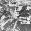
Oblique aerial view of the field system and building, looking NE. |
2/3/2010 |
Item Level |
|
|
Digital Files (Non-image) |
GV 006511 |
Records of the Royal Commission on the Ancient and Historical Monuments of Scotland (RCAHMS), Edinbu |
Distribution map of medieval and later settlement. |
1996 |
Item Level |
|
|
Digital Files (Non-image) |
GV 006514 |
Records of the Royal Commission on the Ancient and Historical Monuments of Scotland (RCAHMS), Edinbu |
Plan of archaeological landscape at Glen Fender |
1997 |
Item Level |
|
 |
On-line Digital Images |
DP 266706 |
Records of the Royal Commission on the Ancient and Historical Monuments of Scotland (RCAHMS), Edinbu |
Distribution map of medieval and later settlement. Generated from RCAHMS computer file DC37330ai. |
1996 |
Item Level |
|
 |
On-line Digital Images |
DP 266709 |
Records of the Royal Commission on the Ancient and Historical Monuments of Scotland (RCAHMS), Edinbu |
Plan of archaeological landscape at Glen Fender |
1996 |
Item Level |
|
 |
On-line Digital Images |
SC 1703953 |
RCAHMS Aerial Photography |
Oblique aerial view. |
1993 |
Item Level |
|
 |
On-line Digital Images |
SC 1703954 |
RCAHMS Aerial Photography |
Oblique aerial view. |
1993 |
Item Level |
|
 |
On-line Digital Images |
SC 1703955 |
RCAHMS Aerial Photography |
Oblique aerial view. |
1993 |
Item Level |
|
 |
On-line Digital Images |
SC 1703956 |
RCAHMS Aerial Photography |
Oblique aerial view. |
1993 |
Item Level |
|
 |
On-line Digital Images |
SC 1704018 |
RCAHMS Aerial Photography |
Glen Fender, oblique aerial view, taken from the NE, centred on a hut-circle. The Crieff to Dalnacardoch militray road is visible in the left half of the photograph. |
6/6/1996 |
Item Level |
|
 |
On-line Digital Images |
SC 1704019 |
RCAHMS Aerial Photography |
Glen Fender, oblique aerial view, taken from the W, centred on a hut-circle. The Crieff to Dalnacardoch military road is visible in the right half of the photograph. |
6/6/1996 |
Item Level |
|
 |
On-line Digital Images |
SC 1704020 |
RCAHMS Aerial Photography |
Glen Fender, oblique aerial view, taken from the SW, centred on a hut-circle. The Crieff to Dalnacardoch military road is visible in the right half of the photograph. |
6/6/1996 |
Item Level |
|


