
Thurso Harbour


Harbour (Period Unassigned)
Site Name Thurso Harbour
Classification Harbour (Period Unassigned)
Alternative Name(s) Thurso River; Pentland Firth
Canmore ID 8479
Site Number ND16NW 57
NGR ND 1211 6867
Datum OSGB36 - NGR
Permalink http://canmore.org.uk/site/8479


- Council Highland
- Parish Thurso
- Former Region Highland
- Former District Caithness
- Former County Caithness
ND16NW 57 1211 6867
Harbour [NAT] (centred ND 1212 6865)
OS 1:10,000 map, 1985.
Not to be confused with Thurso, Scrabster Harbour (ND 102 703), for which see ND17SW 5.
For successive adjacent road bridges (to SE, across River Thurso), see ND16NW 59 and ND16NW 392.
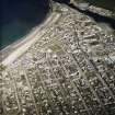
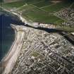
(Location cited as ND 122 367). Harbour, largely 19th century. Quay walls on both sides of the Thurso River, protected by short piers. The works are all constructed of local stone. On the east side are some single-storey sheds, formerly a pavement works, and the remains of a boatyard, with a derelict fishing boat.
J R Hume 1977.
(Location cited as ND 121 684). Thurso: the harbour of Thurso lay in the mouth of Thurso River. Two sloops were recorded here by the Cromwellian Commissioner Tucker in 1656, the next to the S being one of 16 tons at Cromarty [NH76NE 49]. According to a Macfarlane document of 1726, the harbour could be entered by barks of 60 tons, though pilotage was necessary on account of a dangerous rock. Once inside, they could lie in safety. A companion document alludes to a trustworthy anchorage (portu quoque et statione fida). At the time Thurso was engaged in import and export trading. A customs establishment for the whole coastline from Helmsdale to the Point of Stoer had been set up at Thurso in 1707, and the port legalised, but in 1734, an Inverness merchant wrote to John Sinclair of Ulbster, the superior, 'Mr Brody was much wrong to impose on me by assuring me that here was a convenient harbour in Thurso River, whereas there is none fit for a vessel'.
In 1798, though the river was busy with overseas trade, the main anchoring ground seems to have been off Scrabster (ND 102 703), though the harbour there (ND17SW 5) was 'indifferent'. In 1800 the first bridge (ND16NW 59) was built over the river to Thurso town (ND16NW 65), on the W bank, then being developed by Sir John Sinclair. His efforts to enable Thurso to participate profitably in the rise of the herring fishery, as at Wick (ND35SE 66.00), failed. Though an Act of 1802 authorised the building of a harbour for ships of up to 800 tons at spring tides, a weir, a graving dock and a slip for ship-building, and the British Fisheries Society would have paid £1000 towards the £7000 cost of a plan produced by Telford, the required £6000 could not be raised locally.
By 1825, however, Thurso had 17 vessels totalling 1035 tons, and was building three more, and successfully resisted an attempt to remove the customs establishment to Wick. The first shoremaster was appointed, and pawlage charges of one penny a ton were fixed for the use of mooring poles in the river mouth, the proceeds to be used for dredging the channel. The export of Caithness flags for paving stones, begun in 1825 from Castlehill (ND16NE 41.00), led to increased use of the Thurso River harbour facilities. In 1835 the Board of Customs laid off and apportioned the use of all river banks within the boundaries of the port of Thurso; construction of harbour works was inhibited by expense until after 1850. In 1840, the limit of draught for ships in the Thurso River was said to be 12ft (3.65m). At that date 14 ships were owned in the port and others traded there. The paving stone merchants modified the right [E] bank of the river progressively from 1825. A succession of five walls on the river frontage, behind which, partly by the deposition of chips from the stone yards, land was built up, reclaiming an area of 30 or 40 acres [12.1 or 16.2 ha] before 1876. Ships tied up to rough quays so formed, and at low tide were grounded upright. On the left [W] bank, however, it was still possible in the hunger of 1847, for two sloops and a larger vessel to be dragged up the beach by a mob, to stop carts in Shore Street arriving to load bread corn for export.
Structure: on the right [E] bank, further up than the present left [W] bank harbour, one stretch of stone revetment appears older than adjoining modern works. Still further up, there is a square quay of very rough masonry. From each bank, just below the bridge (ND16NW 59), there is a ridge of wasted masonry projecting towards the middle of the river, and retaining a pool at low tide, even when the river itself is very low, which could have been used by boats in early times.
A Graham and J Gordon 1988.
[Thurso] Harbour: stone wharfs and short piers on both sides of the River Thurso. By James Barron, 1890-1.
J Gifford 1992.

