
Lochend Colliery


Bing (19th Century) - (20th Century), Canteen (19th Century) - (20th Century), Colliery (19th Century) - (20th Century), Engine House (19th Century) - (20th Century), Magazine (19th Century) - (20th Century), Mine Lifting And Winding Structure (19th Century) - (20th Century), Plantation Bank(S) (Post Medieval), Rig And Furrow (Medieval) - (Post Medieval)
Site Name Lochend Colliery
Classification Bing (19th Century) - (20th Century), Canteen (19th Century) - (20th Century), Colliery (19th Century) - (20th Century), Engine House (19th Century) - (20th Century), Magazine (19th Century) - (20th Century), Mine Lifting And Winding Structure (19th Century) - (20th Century), Plantation Bank(S) (Post Medieval), Rig And Furrow (Medieval) - (Post Medieval)
Alternative Name(s) Mexican's Hat; Lochend Colliery Pit No. 5; Lochend Pit No 5 And Bing
Canmore ID 83459
Site Number NS86NW 54
NGR NS 8485 6946
Datum OSGB36 - NGR
Permalink http://canmore.org.uk/site/83459


- Council North Lanarkshire
- Parish New Monkland (Monklands)
- Former Region Strathclyde
- Former District Monklands
- Former County Lanarkshire
Scheduled as Lochend Pit No 5 and bing.
Information from Historic Scotland, scheduling document dated 19 November 2003.
(Location cited as NS 8487 6945). LOCHEND 5 Colliery
Location: Caldercruix
Previous Owners: Brownieside Coal Company Limited
Types of Coal: Anthracite
Sinking/Production Commenced: c.1880
Year Closed: 1948
Year Abandoned: 1948
Average Workforce: 89
Peak Workforce: 101
Peak Year: 1948
Shaft/Mine Details: No. 5 shaft 70m (to Coxrod or Lower Drumgray). Air Pit 46m to Upper Drumgray.
Details in 1948: 19,250 tons per annum. 101 employees. Screening facilities: bar screen only [mechanical device for separating different sizes of coal using parallel inclined bars spaced at regular intervals, the coal sliding down the incline under gravity], dross [small particles of coal resulting from the mining process] is hand-fed into the washer. Bash-type washer [coal preparation to separate coal from dirt whereby water is forced through coal using a plunger, perforated plate and tank] made partly by Dickson and Mann. Method of working longwall, hand-filled into tubs, with aid of coal-cutting machinery. No conveying machinery. Canteen, but no baths. All electricity AC, and supplied from outside by Clyde Valley Power Company Estimated future life of colliery only 3 years. Report dated 28-08-1948.
Other Details: Notable for its extraordinary bing, known locally as 'the Mexican's Hat'.
M K Oglethorpe 2006.
Field Visit (11 August 1992)
NS86NW 54 8485 6946
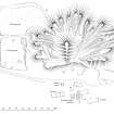
The remains of Lochend Colliery Pit No.5 are remarkable for the survival of a well-preserved bing together with a suite of pit-head buildings.
The bing, known locally as 'The Mexican's Hat', dominates the site and comprises a complex crow's foot bing overlain by a conical heap (the peak of the hat) formed by a conveyor belt. The bing lies to the SE of the pit-head with both the crow's feet tip-lines and the line of the conveyor orientated towards it. The crow's foot bing exhibits a complex sequence of formation (clearly visible on the SE, where a sequence of tip lines can be seen). Shallow depressions along the crests of many of the crow's feet indictate the courses of barrow runs. The centre of the crow's feet bing is overlain by a large conical mound, formed by a conveyor, the line of which is marked by several wooden posts on the NW side. The depiction of the spoil on the revised edition of the OS 6-inch map (Lanarkshire 1922, sheet iv) suggests that the crows feet bing had yet to reach its full extent by that date.
To the SE of the bing there are two interconnecting settling ponds, formed on embanked spoil. The line of the railway which runs between the bing and the pit-head buildings is marked by a farm track.
To the N of the railway line there are the remains of at least four buildings and several depressions which may mark the location of the shaft(s). A two-storey brick engine-house is situated immediately to the N of the railway line, while the three compartment footings of what may have been the washer lie to the NE. A brick-built winding mechanism base lies to the NW of the engine-house, aligned towards a C-shaped depression, possibly a pit-head. To the WSW of the winding mechanism base there are the grass-covered remains of what may have been an earlier base, comprising two parallel mounds, also aligned towards a depression, perhaps the 'old shaft' shown on the revised edition of the OS 6-inch map (ibid). Further to the WNW there is a sub-rectangular, partly grass-covered, concrete floor, probably the canteen. A roofed brick-built magazine is situated to the NW of the mine.
Lochend Colliery Pit No. 5 was opened in about 1880 by the Brownside Coal Company and in 1948 had an estimated three years of production remaining (NMRS, MS 819). The 2nd edition of the OS 6-inch map (Lanarkshire 1899, sheet iv) depicts two roofed structures beside the railway and loop, but no spoil. By the date of the revised edition (ibid) there is a bing on the S side of the railway, the same two roofed structures and an old shaft marked between the bing and the railway. The structures on the 2nd and revised edition of the OS 6-inch maps (ibid) do not readily match those visible on the date of visit, which may date from relatively late in the life of the mine. The Gazetteer of NCB Mines (NMRS, MS 819) records that Lochend No. 5 had a washer and a canteen in 1948, corresponding with two of the structures recorded.
The ground around the mine is covered by cultivation rigs of two distinct types. Broad, slightly sinuous rigs, measuring about 7m between furrows, have been sub-divided to form straighter rigs measuring between 3m and 4m across. In places only the narrower, straighter rig is visible, perhaps indicating new intake or the obliteration of the earlier rigs. A network of parallel earthen shelter-belt banks overlie the rig and bear fragments of hawthorn hedging.
(CSW 4245)
Visited by RCAHMS (DCC) 11 August 1992.
Measured Survey (28 August 1992 - 28 August 1992)
RCAHMS surveyed the winding gear stance at Lochend Colliery on 28 August 1992 at a scale of 1:125.
Measured Survey (27 August 1992 - 28 August 1992)
RCAHMS surveyed the buildings and bing at Lochend Colliery, Pit No.5 on 27 August 1992 at a scale of 1:500. The resultant plan was redrawn in ink and published at a scale of 1:1250 (RCAHMS 1998b, Fig.24). The winding gear stance was surveyed on 28 August 1992 at a scale of 1:125.

