
Following the launch of trove.scot in February 2025 we are now planning the retiral of some of our webservices. Canmore will be switched off on 24th June 2025. Information about the closure can be found on the HES website: Retiral of HES web services | Historic Environment Scotland
Punds Water


Chambered Cairn (Neolithic)
Site Name Punds Water
Classification Chambered Cairn (Neolithic)
Canmore ID 828
Site Number HU37SW 1
NGR HU 3245 7124
Datum OSGB36 - NGR
Permalink http://canmore.org.uk/site/828


- Council Shetland Islands
- Parish Northmavine
- Former Region Shetland Islands Area
- Former District Shetland
- Former County Shetland
HU37SW 1 3245 7124.
(HU 3244 7124) Cuml (OE)
O.S.6"map, Shetland, 2nd ed.,(1903).
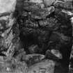
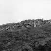
A heel-shaped chambered cairn composed of large boulders and standing about 5' high above the surrounding peat. The facade measures more than 50' across, and from back to front the cairn measures 32'. The chamber was cleared by RCAHM in 1930.
A S Henshall 1963; RCAHMS 1946; T H Bryce 1940.
As described and planned by Henshall.
Visited by OS(WDJ) 27th May 1968.
Field Visit (10 July 1930)
Heel-shaped Cairn, Punds Water, Mangaster.
This monument (Fig. 608), the largest example of the type of chambered cairn that is peculiar to Shetland, and one of the best preserved, is situated on the W shoulder of Skipta Hill between Punds Water and Mina Water. Built of white granitic boulders, measuring on the average about 2 ft by 1 ft, it rises some 5 ft above the surface of the knoll on which it stands. In the centre of the mass of stones a roofless and rifled chamber, with a passage leading to it, lies open to the sky. The foundations of the outer wall-face of the cairn can be traced in the fallen material round the back and sides, while several courses of the wall of large stones which formed the frontal façade survive along its N half, and the angle at this extremity is marked by an upright stone 4 ft 9 in high. The S half is less well preserved.
Fig. 616 shows the original ground-plan of the cairn. Its outline has something of the shape of an official cocked-hat in profile, with dimensions of over 50 ft at the base and 32 ft from base to apex. The basal angles have been prolonged into short horns, and, as seen at the northern and surviving horn, the walling that encloses the back and sides of the cairn joins the end of the frontal façade at an acute angle. The façade shows a very slight degree of curvature and has at its central point an opening, the entrance to a passage leading to the interior. The passage (Fig. 607), once roofed, is 12 ft. long by 2 ft. 6 ins. wide, contracting about the middle to 1 ft. 5 in. The chamber (Fig. 606) is of the characteristic trefoil form, having a recess at the inner end and one on each side, the terminal recess being the largest. Including the recess at the end, it is 6 ft. long, and it is 7 ft. wide from the back of one lateral recess to the other. The walls, which still stand 4 ft. 9 in. high, are built in regular courses of masonry without any use of upright slabs, and their angles are sharp, not rounded. The floor is not paved, but consists of clay in which are embedded red water-rolled pebbles, which must have been brought from a distance. At the date of visit the stones which had formed the roof lay in a heap on the floor.
RCAHMS 1946, visited 10 July 1930.
O.S.6"map, Shetland, 2nd ed.,(1903).
[the plane-table survey undertaken on this date was superceded]
Measured Survey (3 August 1931)
RCAHMS surveyed the Punds Water chambered cairn on 3 August 1931 by plane-table and alidade, superceding a plan taken on 10 June 1930. The resultant plan and section were redrawn in ink and published at a reduced size (Bryce 1940, fig. 1; RCAHMS 1946, fig. 616).
Publication Account (1997)
This is one of the best-preserved heel-shaped cairns, probably because it lies in what has become, since the formation of blanket peat, an inhospitable area of small lochs and moorland, although around 3,000 years ago its potential for farming would have been considerably better (colour photograph on p.32). The cairn was built on a low knoll and the kerb can be traced very easi ly, one or more courses high, showing that the lower part of the cairn had a vertical external face (there are tumbled stones beyond the original face); in the centre of the concave facade on the ESE side is a passage leading to a trefoil-shaped burial chamber. Both chamber and passage are now roofless, bur their walls still stand over a metre in height, in places using very large stones.
A second tomb was excavated in 1959 on the west side of Punds Water, which was almost circular externally with an interior divided into five small benched cells round a central area, very reminiscent of domestic houses of the same period (HU 322714) .
Information from ‘Exploring Scotland’s Heritage: Shetland’, (1997).

