
Following the launch of trove.scot in February 2025 we are now planning the retiral of some of our webservices. Canmore will be switched off on 24th June 2025. Information about the closure can be found on the HES website: Retiral of HES web services | Historic Environment Scotland
Bynack Lodge


Game Larder (19th Century) - (20th Century), Hunting Lodge (19th Century), Kennels (19th Century), Stable(S) (19th Century)
Site Name Bynack Lodge
Classification Game Larder (19th Century) - (20th Century), Hunting Lodge (19th Century), Kennels (19th Century), Stable(S) (19th Century)
Alternative Name(s) Mar Lodge Estate; Bynack Burn; Bynack Lodge To Ruigh Nan Clach; Bynack Shieling
Canmore ID 81210
Site Number NO08NW 17
NGR NO 0005 8555
Datum OSGB36 - NGR
Permalink http://canmore.org.uk/site/81210


- Council Aberdeenshire
- Parish Crathie And Braemar
- Former Region Grampian
- Former District Kincardine And Deeside
- Former County Aberdeenshire
NO08NW 17 0005 8555
See also NO08NW 10, NO08NW 16, NO08NW 19.00, NO08NW 20.
Scheduled (with NO08NW 10, NO08NW 16, NO08NW 19.00, NO08NW 20 ) as 'Mar, shielings, enclosures and buildings, Bynack Lodge to Ruigh nan Clach...'
Information from Historic Scotland, scheduling document dated 30 March 2009.
Field Visit (19 July 1993)
NO08NW 17 0005 8555
See also NO08NW 10, 16, 19.00 and 20.
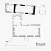
Bynack Lodge and its outbuildings are situated on a terrace to the S of the Bynack Burn. These include the Lodge itself, a second stone building, a walled-garden, a subterranean cold-store, a range of stances for timber buildings to the rear of the Lodge, and a stone setting. There are the footings for two further outbuildings about 100m to the SE and a drystone wall encompasses 0.4ha of ground to the W of the Lodge.
The Lodge (MAR93 507) is a three-bay stone building of two floors, the upper floor being attic accommodation, with a secondary wing added to the rear. The front is faced with squared granite blocks, but the rest is built of mortared rubble. The main part measures 12.25m from NNE to SSW by 5m transversely within walls 0.6m thick and 2.5m high. The entrance is in the middle of the ESE side between two windows, with the traces of a gabled timber porch. The wing extends 4.15m to the WNW from the SSW end of the rear wall with direct access from the main building, despite having its own external entrance on the NNE, and measures 3.6m in breadth. There are scarcements for the first floor and fireplaces in all the gables and there are drip courses at the base of the chimney stacks.
To the rear of the Lodge there is a second stone building (MAR93 508), also originally of three bays, on a slightly different alignment. It measures 9.4m from NNE to SSW by 3.2m within mortared rubble walls 0.6m in thickness and 1.9m in height. The building has been extended 3.55m to the SSW in a style to match the main Lodge; this additional compartment has its own entrance and a fireplace to heat a room in the attic. There are also slight traces of an extension to the NNE.
Behind these buildings to the NW there is a range of stances and other structures for a variety of outbuildings associated with the hunting-lodge (MAR93 521-5). From N to S these comprise a stables, a building of unknown function, a concrete kennels and, slightly to the SW, a game-larder. Further to the NW again are the footings of what may have been a meat-safe and a subterranean cold-store. The stables measure 9.1m from WNW to ESE by 5.1m transversely over a stone plinth for a timber-framed superstructure, with a threshold slab in the WNW end. An open-ended shed has been added to the E end of the SSW side, measuring 4.9m from WNW to ESE by 3.1m transversely with no plinth along the ESE, whilst there is a terrace suggestive of a lean-to structure on the WNW end of the same side. Internally there are three pairs of post-holes making three bays for horses. The second building is of similar construction and measures 9.8m from NE to SW by 4.3m transversely. The kennels are on the same alignment immediately S of this building. Of two bays it measures 4.4m from WNW to ESE by 4m transversely over a concrete plinth with bolts for fixing a metal railing. The bays are subdivided into two compartments, a smaller inner one presumably for a shelter. The meat-store is accessible via a path from N end of the middle building and comprises a small rectangular timber structure set on a plinth, 2.5m in length by 1.75m overall, with a slab-stone floor. The game-larder is built on a different alignment and does not appear on the 1st edition OS 6-inch map (Aberdeenshire 1869, sheet civ). It also comprises a stone-plinth for a timber frame, but this time with a slab-stone floor and a central stone post-setting, 0.3m square, for a roof-support. The building measures 6m from WNW to ESE by 5m transversely over a stone plinth 0.15m in thickness and 0.2m in height. The subterranean cold-store lies a short distance to the NW and comprises a curving stone stair of five steps down into a stone-lined chamber, 2m long by 1.2m in breadth and 1m deep. About 25m to the WSW of the game-larder is a square stone setting 0.5m across of unknown function.
The two buildings to the SE of the main group (MAR93 502-3) are laid-out in echelon formation and there is a cobbled stand on the N side of the E building, which measures 6.8m from N to S by 2.5m transversely. Both buildings may have provided additional stabling, but are of different construction. The E building, which is depicted as roofed on the 1st edition of the OS 6-inch map (Aberdeenshire 1869, sheet civ), measures 9.9m from E to W by 3.65m transversely within faced rubble walls 0.75m in thickness and up to 1.2m in height, where best preserved, with two entrances and a stone-built terrace on the S and a drain around the N, where it is set into the slope of the ground. The core of the W building is based upon a stone-plinth for a timber superstructure, 0.3m in thickness, measuring about 9m in length by 4.5m in breadth. A mortared rubble wall, 0.5m thick and standing up to 1m in height, forms three sides of a passage along the N side, measuring 11.8m in length by about 1m in breadth, and at the E end where there may be an entrance on the S, it extends 3.25m beyond the timber building-stance. The interior of the main block is subdivided into two unequal compartments and there are rows of flat stones set upon edge as if to support a timber floor.
Most of the these buildings are depicted as roofed on the 1st edition of the OS 6-inch map (Aberdeenshire 1869, sheet civ), when it was called Bynack Shieling, and is described at the time as 'A one storied neatly ordered shooting Lodge with various useful offices attached the whole owned by the Earl of Fife' (Ordnance Survey Name Book [ONB] 1869).
(MAR93 502-3, 507-8, 521-5)
Visited by RCAHMS (PJD) 19 July 1993.
Measured Survey (9 June 1993)
RCAHMS surveyed Bynack Lodge on 9 June 1993, creating a site plan at a scale of 1:500. The resultant plan was redrawn in ink and published at a scale of 1:2500 (RCAHMS 1995b, Fig.28).
Measured Survey (9 June 1993)
RCAHMS surveyed Bynack Lodge on 9 June 1993, creating a ground plan, first floor plan and elevation of the lodge at 1:100. The resultant plans were redrawn in ink and published 1:200 (RCAHMS 1995b, Fig. 29).

