
Fort William - Fort Augustus - Inverness Military Road


Military Road (18th Century)
Site Name Fort William - Fort Augustus - Inverness Military Road
Classification Military Road (18th Century)
Alternative Name(s) Laggan
Canmore ID 81103
Site Number NN29NE 5
NGR NN 2870 9600
NGR Description NN 2801 9500 to NN 2999 9818
Datum OSGB36 - NGR
Permalink http://canmore.org.uk/site/81103


- Council Highland
- Parish Kilmonivaig
- Former Region Highland
- Former District Lochaber
- Former County Inverness-shire
NN29NE 5 2801 9500 to 2999 9818
NN 2800 9500 - 2864 9583 Wade's road on impassable forest track.
NN 2864 9583 - 2987 9798 A82 on line.
NN 2987 9798 - 2999 9818 The superseded trunk road on the line of the Wade road is now a disused track.
Visited by OS, June 1964 and February 1979.
Initially the military road takes the form of a grassy forestry track heading N. The track becomes very overgrown with gorse and trees in the vicinity of NN 2854 9569 and finally the overgrowth becomes so dense that the track becomes impassable.
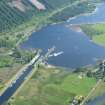
There is some uncertainty as to the line taken by the military road through Laggan. It may have taken the route now overlain by the A82 or it may have followed a line slightly further W. There are no extant signs of the latter route apart from a short section of disused grass track visible immediately to the S of the Laggan Swing Bridge. It is possible to see the overgrown remains of old asphalt metalling between fragments of flanking banks.
Just S of Laggan Swing Bridge the military road heads E.
M Logie (Highland Council) 1997; NMRS, MS/1007/3.
Ground Survey (2009)
Survey of the 18th-century Military Road Network – Lochaber
Landscape assessment
Colin Shepherd
The following features were recorded during a landscape management survey of the 18th-century military road network as described under military roads IRS Foyers, Boleskine and Abertarff/Dores.
NN 1642 7852 Leanachan Water level on the downslope side of this portion of military road suggests the presence of a blocked culvert. L006
NN 1008 5931 Invercoe A revetted track deviates from the modern way for a short distance behind Invercoe House. This might be a survival from the military route leading from the ferry from Callert through Invercoe to Glencoe. L016
NN 1036 5902 Invercoe Square stone culvert which might be early. L017
NN 1048 5891 Invercoe Revetment and early square stone culvert beside modern and working pipe. The stone culvert is not visible on the upslope side, but the road is 6m wide here. The culvert might well relate to the early road. L018
NN 1081 5872 Invercoe Square stone culvert which might be early considering the narrow width of the road. L019
NN 1030 5904 Invercoe A section of track diverges from the modern course and the edge of the modern track contains some possible early cobbling. L021
NN 1012 5925 Invercoe Square stone culvert beside Invercoe House, possibly early. L020
NN 0736 5980 Callert Possible previously unrecognised stretch of late military road running from NN 0769 5972 to NN 0725 5987. Very well preserved. It has been truncated by quarrying and rock removal for the modern road. This appears to have remained the course until after the 1st Edition OS map was drawn. L023
NN 0755 5976 Callert Blocked culvert on above-noted section of road. Deeply covered in pine needles and debris but seems to be made of stone and probably early. L024
NN 0781 5970 Callert Hollow-way meeting modern road and L023 at a fording point. It may be the precursor of the military road or a track to higher pasture ground. L025
NN 0825 6004 Callert Stretch of bank running parallel to the modern road. It is probably either a land boundary or related to the course of the earlier road. L026
NN 0504 6671 Inchree Stretch of early military road leaving the course of the present forestry track and heading down to cross the watercourse avoided by the present route. L023
NN 2937 9554 Laggan A gravel bank along the side of the loch might be an earlier route. It is not dissimilar to a stretch a few hundred yards to the S which is validated. L039
NN 0468 6596 Allt Coire Longhouse measuring c20 x 5m externally. Part of Nan Cadrach Corrychurrachan settlement noted on an 18th-century estate plan but not incorporated into RCAHMS NN06NW 3 (see below). L029
NN 0480 6604 Allt Coire Nan Cadrach At least one further building was noted beside a track running from L029. L030
NN 0480 6603 Allt Coire Nan Cadrach The settlement
is depicted on an 18th-century estate plan as the preimprovement
settlement of Corrychurrachan and noted as Allt Coire Nan Cadrach under RCAHMS NN06NW 3. More of
the settlement remains are extant than has been previously recorded. L031
NN 0447 6593 Allt Coire Nan Cadrach Stone dyke in the area of Dalvaia as recorded on an 18th-century estate
plan. This would have formed a part of the settlement of Corrychurrachan (see above). L032
NN 2174 7839 Leanachan The footings of two small cottages or byres survive in the area known from 18th century estate plans as Leanachan Mor and Leanachan Beg.
Archive: FCS, Inverness and RCAHMS
Funder: Forestry Commission Scotland

