
Dunragit


Pit Alignment (Prehistoric)
Site Name Dunragit
Classification Pit Alignment (Prehistoric)
Canmore ID 78928
Site Number NX15NE 69.02
NGR NX 15192 57265
NGR Description Centre
Datum OSGB36 - NGR
Permalink http://canmore.org.uk/site/78928


- Council Dumfries And Galloway
- Parish Old Luce
- Former Region Dumfries And Galloway
- Former District Wigtown
- Former County Wigtownshire
NX15NE 69.02 1512 5727 - 1525 5725
See NX15NE 69.00 and NX15NW 76.00
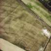
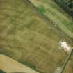
Aerial Photographic Transcription (10 September 1992 - 16 December 1992)
An aerial transcription was produced from oblique aerial photographs. Information from Historic Environment Scotland (BM) 31 March 2017.
Aerial Photographic Interpretation (16 December 2021)
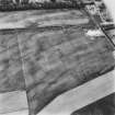
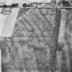
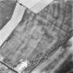
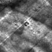
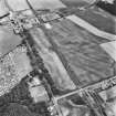
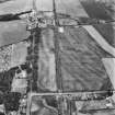
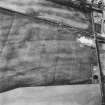
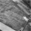
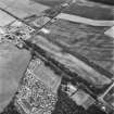
This pit-alignment, which has been recorded as cropmarking on oblique aerial photographs (RCAHMSAP 1992), is situated on level ground about 90m E of the Dunragit timber enclosure (NX15NW 76.1 and 76.2). It extends at least 145m on an E and W orientation. A possible henge monument (NX15NE 69.03) is located at its W end, while a pit or timber circle (NX15NE 69.01) has been recorded some 25m S of its E end.
Information from HES Archaeological Survey (K. Millican) 16 December 2021.
Note (23 August 2022)
The location, classification and period of this site have been reviewed.

