
Pabbay, Baile Fo Tuath


Rig And Furrow (Medieval) - (Post Medieval), Township (Post Medieval)
Site Name Pabbay, Baile Fo Tuath
Classification Rig And Furrow (Medieval) - (Post Medieval), Township (Post Medieval)
Alternative Name(s) Northtown; Northton
Canmore ID 75706
Site Number NF98NW 2
NGR NF 9040 8815
NGR Description Centred on NF 9040 8815
Datum OSGB36 - NGR
Permalink http://canmore.org.uk/site/75706


- Council Western Isles
- Parish Harris
- Former Region Western Isles Islands Area
- Former District Western Isles
- Former County Inverness-shire
NF98NW 2 centred on 9040 8815
Baile-fo-thuath: North-town; a number of ruined houses, deserted
c.1850.
Name Book, Inverness-shire (Hebrides)
A small township comprising five unroofed buildings is depicted on the 1st edition of the OS 6-inch map (Inverness-shire, Island of Harris 1881, sheet xxi) and on the current edition of the OS 1:10000 map (1971).
Information from RCAHMS (SAH) 20 March 1997
Field Visit (27 July 2011)
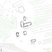
The remains of this farmstead lie close to the E coast of Pabbay and comprise six buildings and an enclosure on a gently sloping terrace to the N of an unnamed stream and amidst extensive remains of former cultivation. The largest building (NF 90408 88166) is probably a byre-house which has been constructed with its long axis dropping down the slope to the ENE. It measures 17.3m by 4.8m within drystone walls 1.6m in thickness and 0.7m in height with a doorway (1m wide) at the ENE end of the SSE side. The higher, WSW, end of the building overlies the ENE side of an earlier building that measures at least 15m in length over walls reduced to little more than a low bank. The four other buildings are of similar construction to the first and their walls largely stand to a height of about 0.7m. The building (NF 90422 88126) on the SE side of the steading may have been a kiln barn. The enclosure lies immediately N of the buildings. Two groups of what are probably grain storage pits are visible on the S side of the stream. One of them (at NF 9029 8809), about 90m to the WSW of the steading, is described elsewhere (see NF98NW 6); the other (NF 9037 8807) lies about 50m to the SSW and comprises a cluster of small grass-grown hollows.
The farmstead and its cultivated land are likely to have been abandoned when Pabbay was converted into a sheep farm in the 1840s (Lawson 1994). Except for the one building which is clearly of early date and is not shown at all, all the others are depicted unroofed on the 1st edition of the OS 6-inch map (Inverness-shire (Hebrides) 1881, Sheet XXI).
Visited by RCAHMS (GFG) 27 July 2011.
Measured Survey (22 May 2019)
The post-medieval farmstead at Northton (Baile fo Tuath) was surveyed in detail in 2019. The site is as described in 2011.
Visited by HES Survey and Recording (GFG) and R Reid 22 May 2019.

