
Ashentrool


Corn Drying Kiln (Post Medieval), Enclosure (Post Medieval), Farmstead (19th Century), Farmstead(S) (18th Century), Sheep House (Post Medieval)
Site Name Ashentrool
Classification Corn Drying Kiln (Post Medieval), Enclosure (Post Medieval), Farmstead (19th Century), Farmstead(S) (18th Century), Sheep House (Post Medieval)
Alternative Name(s) Ashintrool; Tounhead Of Loss
Canmore ID 74629
Site Number NS89NW 56.01
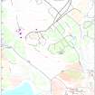
NGR NS 8299 9931
NGR Description NS 8299 9931 and NS 8300 9939
Datum OSGB36 - NGR
Permalink http://canmore.org.uk/site/74629


- Council Stirling
- Parish Logie (Stirling)
- Former Region Central
- Former District Stirling
- Former County Stirlingshire
Note (1991)
NS89NW 56.01 8300 9939 and 8299 9931
This farmstead is depicted in ruins on the 1st edition of the Ordnance Survey 6-inch map, (Perthshire and Clackmannanshire, 1865-6, sheet cxxxiii) has associated cultivation remains, field banks, enclosures and a well preserved corn-drying kiln.
Sponsor: Central Regional Council
L Main 1991
Note (27 August 1996)
This farmstead, which comprises four roofless buildings, is depicted on the 1st edition of the OS 6-inch map (Stirlingshire sheet x, 1865) and annotated 'Ashintrool (in ruins)'. Three roofless buildings are shown on the current edition of the OS 1:10000 map (1979).
Information from RCAHMS (PM) 27 August 1996
Field Visit (5 June 1997)
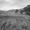
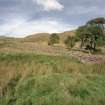
This settlement is situated in rough pasture on the E bank of an unnamed burn draining into the Lossburn Reservoir. At least two distinct phases of construction can be identified: a farmstead which is characterised by faced-rubble footings, lies at the S end of the site (NS 8299 9931) and is the most recently occupied part of the site. To the N (at NS 8300 9939) there are a scatter of buildings and enclosures defined by grass-grown footings which represent an earlier phase of occupation.
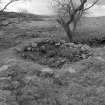
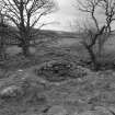
The later farmstead is depicted as roofless on the 1st edition of the OS 6-inch map (Perthshire and Clackmanannshire 1865-6, sheet cxxxiii; Parts of Stirlingshire 1865-6, sheets x and xi) and annotated 'Ashintrool (in ruins)'; It may date to the late 18th and early 19th centuries. The faced-rubble footings of three rectangular buildings form a rough square around a hollow which may have been a yard. The dwelling (MENS97 99) lies along the N side of the yard and has a large sycamore growing out of the S wall. The building measures 18.2m by 3.8m internally and has been divided into two compartments, with a fireplace and what may have been a press in the E end. The other two buildings are smaller; that to the S of the dwelling (MENS97 98) may have been a byre, while that to the SE (MENS97 100) has also been divided into two compartments with an open-ended outshot to the S, probably a cart shed. To the S of the byre there is an oval garden enclosure bounded by a low stony bank, a build-up of soil and several trees. To the N of the buildings a kiln (MENS97 101) has been dug into the W bank of the deeply incised gully of the burn. The kiln-bowl measures 2.7m in diameter within a rubble facing and is at least 1m in depth. A slight ledge around the lip of the bowl may mark the original height of the drying floor. The fire hole is levelled into the side of the gully on the WSW and to the N of the bowl there is a barn which measures 2.6m by 1.9m internally.
The grass-grown footings of the earlier buildings are scattered along the W bank of the burn to either side of the drystone wall which overlies some of the buildings. There are three farmsteads (NS 8303 9939; 8302 9946; 8298 9949), each comprising two or three buildings, one of which is larger than the others, and up to three enclosures, probably garden plots and yards. The larger buildings (MENS97 136, 138, 142) measure between 7.2m by 2.7m and 16.4m by 3.2m internally, although in the latter case a third of the length of the structure is an outshot. In the southern farmstead, which is also the largest, comprising three buildings and three enclosures, there is a C-shaped hollow, measuring about 2.1m in diameter and 0.3m in depth, which may have been a kiln or a midden.
(MENS97 98-101, 136-44)
Visited by RCAHMS (DCC) 6 May and 5 June 1997

