
Pricing Change
New pricing for orders of material from this site will come into place shortly. Charges for supply of digital images, digitisation on demand, prints and licensing will be altered.
Clais An Dunain


Clearance Cairn(S) (Period Unassigned), Shieling Hut(S) (Post Medieval)
Site Name Clais An Dunain
Classification Clearance Cairn(S) (Period Unassigned), Shieling Hut(S) (Post Medieval)
Canmore ID 71086
Site Number NC27SE 9
NGR NC 2521 7266
Datum OSGB36 - NGR
Permalink http://canmore.org.uk/site/71086


- Council Highland
- Parish Durness
- Former Region Highland
- Former District Sutherland
- Former County Sutherland
NC27SE 9 2521 7266.
NC 256 727: A structure, measuring 9m by 6m, of laid flags and boulders lies on a grassy shelf in the lee of the slope below the 250ft (sic) contour on the south side of the valley. It has been quarried to build three circular shielings onto it.
T C Welsh 1972x.
NC 2521 7268. A complex comprising two contiguous, collapsed bothies, 3.9m by 2.3m and 3.5m by 2.5m, with four adjoining lambing pens, 2m in diameter. A small area of the valley to the east has been cleared of stones, and two or three clearance heaps exist.
Visited by OS (NKB) 28 April 1980.
Remains of the two collapsed bothies were not found.
Lieu 2000, 7.
This site was originally described as a series of collapsed bothies. The site occupies a piece of land behind a natural promontory, however it does not conform to the same structural dimensions of other bothies on the range. The structure stands alone in the landscape and is a fairly prominent feature there are several circular annexes to the structure. The structure has completely collapsed and as such is in a very poor condition. Without excavation of this building its date and purpose remain undefined.
Street 2001, 26.
Field Visit (28 April 1980)
Field visit by Ordnance Survey.
Measured Survey (9 August 2008)
RCAHMS surveyed the shieling group at Clais an Dunain on 9 August 2008 with plane table and alidade producing a ground plan at a scale of 1:250.
Field Visit (2008)
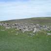
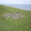
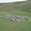
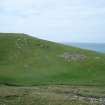
At least one building and six huts, all now largely reduced into a single large heap of loose rubble measuring 15m from NE to SW by 13m transversely, are situated on a gentle SE-facing slope close to where the Allt Clais an Dùnain runs into the sea. The earliest visible remains appear to be at the W edge of the rubble heap, where the NW end of a round-ended building (CWTC08 394) has been set into the slope to a depth of at least 0.5m. Little other than some coursed stonework is evident of this structure because it is otherwise overlain by the rubble debris of two later huts (CWTC08 391 & 392). At the centre of the site, an oval hut (CWTC08 101), measuring 4m from NE to SW by 2.2m transversely within a rubble wall, seems to overlie the fragmentary remains of a similarly sized hut (CWTC08 389) immediately to the NW, the NE end of which is overlain by a much smaller oval hut (CWTC08 390). One other hut (CWTC08 393), which is situated at the S side of the heap, has a square SW end and may incorporate the remains of an earlier building.
The huts lie adjacent to a small area of ground, running SE down to a stream, which has been largely cleared of its surface stone. The largest of three grass-grown clearance cairns within this area measures 2.8m in diameter.
(CWTC08 101, 389–94)
Visited by RCAHMS (AL, IP) 5 August 2008.

