
Following the launch of trove.scot in February 2025 we are now planning the retiral of some of our webservices. Canmore will be switched off on 24th June 2025. Information about the closure can be found on the HES website: Retiral of HES web services | Historic Environment Scotland
RCAHMS Archaeological and Architectural Survey: Cape Wrath Training Centre


Date 4 August 2008 - 15 August 2008
Event ID 556486
Category Project
Type Project
Permalink http://canmore.org.uk/event/556486
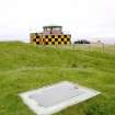
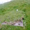
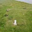
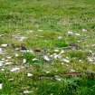
In August 2008 an archaeological and architectural survey was undertaken by RCAHMS of the Cape Wrath Training Centre (CWTC), Highland. The survey was commissioned as a partnership project by Defence Estates (Ministry of Defence) to provide a baseline survey to enhance the historic component of the Land Management Plan for the CWTC. The survey set out to record all visible archaeological features and architectural structures, map them using differential Global Positioning System (dGPS), digitally photograph them, and assess and record their condition using criteria defined by Defence Estates. The survey also recorded all the redundant and current boundaries around and within the centre. Sufficient time was available towards the end of the survey to enable detailed measured drawing surveys to be undertaken of some of the more interesting monuments within the CWTC.
Information from HES Survey and Recording (JRS) 18 April 2018.

| Event | Type | Subtype | Notes | Date |
|---|---|---|---|---|
| 569577 | RECORDING | FIELD VISIT | This road runs for a distance of about 1300m from Kearvaig farmsteading and hunting lodge (NC27SE 13; NC 2923 7265) to its junction (NC 2982 7175) with the road (NC27SE41) that links the ferry terminal on the Kyle of Durness (NC 3708 6603) to the lighthouse (NC27SE 3) at Cape Wrath. It is little more than a metalled track cut into the foot of the natural slope. [...] | 6 August 2008 |
| 1116826 | RECORDING | FIELD VISIT | The location (NC 281 707) quoted by Dr Welsh (1972, 42) of an oval shieling-hut lies within an extensive peat bog characterised by natural mounds and water-filled shell- and bomb-craters. At least one of these mounds, which has a deflated summit, could easily have been mistaken for a shieling-hut or mound. Street (2001, 12) was incorrect in suggesting that there are clearance cairns in the vicinity. [...] | 6 August 2008 |
| 863822 | RECORDING | FIELD VISIT | NC36NW 5 32728 69195 [...] | 6 August 2008 |

DP 047220
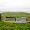
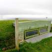
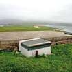
Faraid Head forward observation post (hatch), from SW.
Records of the Royal Commission on the Ancient and Historical Monuments of Scotland (RCAHMS), Edinbu
4/8/2008
© Crown Copyright: HES

DP 047221
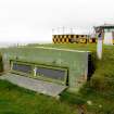
Faraid Head tank, view from SE.
Records of the Royal Commission on the Ancient and Historical Monuments of Scotland (RCAHMS), Edinbu
4/8/2008
© Crown Copyright: HES

DP 047222
Faraid Head tank, view from NW.
Records of the Royal Commission on the Ancient and Historical Monuments of Scotland (RCAHMS), Edinbu
4/8/2008
© Crown Copyright: HES

DP 047223
Faraid Head, general view of demolition debris of building.
Records of the Royal Commission on the Ancient and Historical Monuments of Scotland (RCAHMS), Edinbu
4/8/2008
© Crown Copyright: HES

DP 047224
Faraid Head, generator, view from east.
Records of the Royal Commission on the Ancient and Historical Monuments of Scotland (RCAHMS), Edinbu
4/8/2008
© Crown Copyright: HES

DP 047225
Faraid Head, generator, view from south.
Records of the Royal Commission on the Ancient and Historical Monuments of Scotland (RCAHMS), Edinbu
4/8/2008
© Crown Copyright: HES

DP 047226
Faraid Head, generator, view from south-east.
Records of the Royal Commission on the Ancient and Historical Monuments of Scotland (RCAHMS), Edinbu
4/8/2008
© Crown Copyright: HES

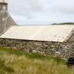
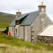
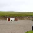
DP 047227
Inshore, shepherd's cottage/barn, view from south-west.
RCAHMS Field Survey Digital Photography
4/8/2008
© Crown Copyright: HES

DP 047228
Inshore, shepherd's cottage/barn, view from E of SSE end of barn.
RCAHMS Field Survey Digital Photography
4/8/2008
© Crown Copyright: HES

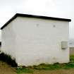
DP 047229
Inshore, shepherd's house, view from the south-west.
RCAHMS Field Survey Digital Photography
4/8/2008
© Crown Copyright: HES

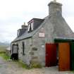
DP 047230
Inshore. Warning sign on NNW gable of house.
RCAHMS Field Survey Digital Photography
4/8/2008
© Crown Copyright: HES

DP 047231
Inshore, shepherd's house, view from the north.
RCAHMS Field Survey Digital Photography
4/8/2008
© Crown Copyright: HES

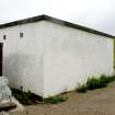
DP 047232
Inshore, shepherd's house, view from the west-north-west.
RCAHMS Field Survey Digital Photography
4/8/2008
© Crown Copyright: HES

DP 047233
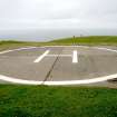
Faraid Head, helicopter pad, view from south-west.
Records of the Royal Commission on the Ancient and Historical Monuments of Scotland (RCAHMS), Edinbu
4/8/2008
© Crown Copyright: HES

DP 047236
Faraid Head, forward observation post, view from the north.
Records of the Royal Commission on the Ancient and Historical Monuments of Scotland (RCAHMS), Edinbu
4/8/2008
© Crown Copyright: HES

DP 047237
Faraid Head, forward observation post, view from the north-west.
Records of the Royal Commission on the Ancient and Historical Monuments of Scotland (RCAHMS), Edinbu
4/8/2008
© Crown Copyright: HES

DP 047238
Faraid Head, forward observation post, view from the west.
Records of the Royal Commission on the Ancient and Historical Monuments of Scotland (RCAHMS), Edinbu
4/8/2008
© Crown Copyright: HES

DP 047239
Faraid Head, forward observation post, view from NNW.
Records of the Royal Commission on the Ancient and Historical Monuments of Scotland (RCAHMS), Edinbu
4/8/2008
© Crown Copyright: HES

DP 047240
Faraid Head, forward observation post, view from WSW with OS triangulation pillar immediately behind.
Records of the Royal Commission on the Ancient and Historical Monuments of Scotland (RCAHMS), Edinbu
4/8/2008
© Crown Copyright: HES

DP 047241
Faraid Head, quarry, general view from NE.
Records of the Royal Commission on the Ancient and Historical Monuments of Scotland (RCAHMS), Edinbu
4/8/2008
© Crown Copyright: HES

DP 047242
Faraid Head, quarry, general view from SE.
Records of the Royal Commission on the Ancient and Historical Monuments of Scotland (RCAHMS), Edinbu
4/8/2008
© Crown Copyright: HES

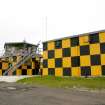
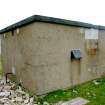
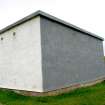
DP 047243
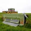
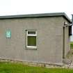
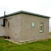
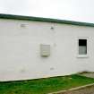
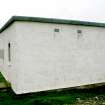
Faraid Head, range control main building, view from E.
Records of the Royal Commission on the Ancient and Historical Monuments of Scotland (RCAHMS), Edinbu
4/8/2008
© Crown Copyright: HES

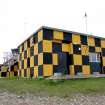
DP 047244
Faraid Head, range control main building, view from the north.
Records of the Royal Commission on the Ancient and Historical Monuments of Scotland (RCAHMS), Edinbu
4/8/2008
© Crown Copyright: HES

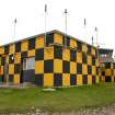
DP 047245
Faraid Head, range control main building, view from the north-east.
Records of the Royal Commission on the Ancient and Historical Monuments of Scotland (RCAHMS), Edinbu
4/8/2008
© Crown Copyright: HES

DP 047246
Faraid Head, range control main building, view from the NNE.
Records of the Royal Commission on the Ancient and Historical Monuments of Scotland (RCAHMS), Edinbu
4/8/2008
© Crown Copyright: HES

DP 047247
Faraid Head, range control main building, view from the south.
Records of the Royal Commission on the Ancient and Historical Monuments of Scotland (RCAHMS), Edinbu
4/8/2008
© Crown Copyright: HES

DP 047248
Faraid Head, range control main building, view from the south-west.
Records of the Royal Commission on the Ancient and Historical Monuments of Scotland (RCAHMS), Edinbu
4/8/2008
© Crown Copyright: HES

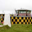
DP 047249
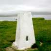
Faraid Head, range control main building, view from WNW. Also showing Ordnance Survey triangulation pillar (NC37SE 14)
Records of the Royal Commission on the Ancient and Historical Monuments of Scotland (RCAHMS), Edinbu
4/8/2008
© Crown Copyright: HES

DP 047250
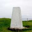
Faraid Head, Ordnance Survey triangulation pillar, view from north-east.
Records of the Royal Commission on the Ancient and Historical Monuments of Scotland (RCAHMS), Edinbu
4/8/2008
© Crown Copyright: HES

DP 047251
Faraid Head, Ordnance Survey triangulation pillar, view from south-east.
Records of the Royal Commission on the Ancient and Historical Monuments of Scotland (RCAHMS), Edinbu
4/8/2008
© Crown Copyright: HES

DP 047252
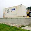
Faraid Head, generator building, view from east.
Records of the Royal Commission on the Ancient and Historical Monuments of Scotland (RCAHMS), Edinbu
4/8/2008
© Crown Copyright: HES

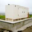
DP 047253
Faraid Head, generator building, view from the south-east.
Records of the Royal Commission on the Ancient and Historical Monuments of Scotland (RCAHMS), Edinbu
4/8/2008
© Crown Copyright: HES

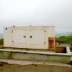
DP 047254
Faraid Head, generator building, view from the south-west.
Records of the Royal Commission on the Ancient and Historical Monuments of Scotland (RCAHMS), Edinbu
4/8/2008
© Crown Copyright: HES

DP 047255
Faraid Head, generator building, view from the west.
Records of the Royal Commission on the Ancient and Historical Monuments of Scotland (RCAHMS), Edinbu
4/8/2008
© Crown Copyright: HES

DP 047256
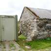
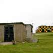
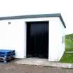
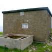
Faraid Head, fuel store, view from NE.
Records of the Royal Commission on the Ancient and Historical Monuments of Scotland (RCAHMS), Edinbu
4/8/2008
© Crown Copyright: HES

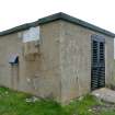
DP 047257
Faraid Head, fuel store, view from the east.
Records of the Royal Commission on the Ancient and Historical Monuments of Scotland (RCAHMS), Edinbu
4/8/2008
© Crown Copyright: HES

DP 047258
Faraid Head, fuel store, view from the north-east.
Records of the Royal Commission on the Ancient and Historical Monuments of Scotland (RCAHMS), Edinbu
4/8/2008
© Crown Copyright: HES

DP 047259
Faraid Head, fuel store, view from the north-west.
Records of the Royal Commission on the Ancient and Historical Monuments of Scotland (RCAHMS), Edinbu
4/8/2008
© Crown Copyright: HES

DP 047260
Faraid Head, fuel store, view from the SSE.
Records of the Royal Commission on the Ancient and Historical Monuments of Scotland (RCAHMS), Edinbu
4/8/2008
© Crown Copyright: HES

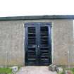
DP 047261
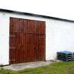
Faraid Head, store building, view from ESE.
Records of the Royal Commission on the Ancient and Historical Monuments of Scotland (RCAHMS), Edinbu
4/8/2008
© Crown Copyright: HES

DP 047262
Faraid Head, store building, view from the north.
Records of the Royal Commission on the Ancient and Historical Monuments of Scotland (RCAHMS), Edinbu
4/8/2008
© Crown Copyright: HES

DP 047263
Faraid Head, store building, view from the south-east.
Records of the Royal Commission on the Ancient and Historical Monuments of Scotland (RCAHMS), Edinbu
4/8/2008
© Crown Copyright: HES

DP 047264
Faraid Head, store building, view from the west.
Records of the Royal Commission on the Ancient and Historical Monuments of Scotland (RCAHMS), Edinbu
4/8/2008
© Crown Copyright: HES

DP 047265
Faraid Head, store building, view from the ENE.
Records of the Royal Commission on the Ancient and Historical Monuments of Scotland (RCAHMS), Edinbu
4/8/2008
© Crown Copyright: HES

DP 047266
Faraid Head, store building, view from the NNW.
Records of the Royal Commission on the Ancient and Historical Monuments of Scotland (RCAHMS), Edinbu
4/8/2008
© Crown Copyright: HES

DP 047267
Faraid Head, store building, view from the WSW.
Records of the Royal Commission on the Ancient and Historical Monuments of Scotland (RCAHMS), Edinbu
4/8/2008
© Crown Copyright: HES

DP 047268
Faraid Head, store building, view from the SW.
Records of the Royal Commission on the Ancient and Historical Monuments of Scotland (RCAHMS), Edinbu
4/8/2008
© Crown Copyright: HES

DP 047269
Faraid Head, sentry post, view from the east.
Records of the Royal Commission on the Ancient and Historical Monuments of Scotland (RCAHMS), Edinbu
4/8/2008
© Crown Copyright: HES

DP 047270
Faraid Head, sentry post, view from the north.
Records of the Royal Commission on the Ancient and Historical Monuments of Scotland (RCAHMS), Edinbu
4/8/2008
© Crown Copyright: HES

DP 047271
Faraid Head, sentry post, view from the south.
Records of the Royal Commission on the Ancient and Historical Monuments of Scotland (RCAHMS), Edinbu
4/8/2008
© Crown Copyright: HES

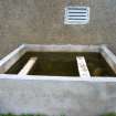
DP 047272
Faraid Head, water tank, view from the NE.
Records of the Royal Commission on the Ancient and Historical Monuments of Scotland (RCAHMS), Edinbu
4/8/2008
© Crown Copyright: HES

DP 047273
Faraid Head, water tank, view from the NNW.
Records of the Royal Commission on the Ancient and Historical Monuments of Scotland (RCAHMS), Edinbu
4/8/2008
© Crown Copyright: HES

DP 047274
Faraid Head, water tank, view from the SW.
Records of the Royal Commission on the Ancient and Historical Monuments of Scotland (RCAHMS), Edinbu
4/8/2008
© Crown Copyright: HES

DP 047275
Faraid Head, fuel store, view from the north-west.
Records of the Royal Commission on the Ancient and Historical Monuments of Scotland (RCAHMS), Edinbu
4/8/2008
© Crown Copyright: HES

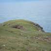
DP 047283
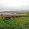
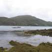
General view over the Kyle of Durness from Keoldale.
RCAHMS Field Survey Digital Photography
4/8/2008
© Crown Copyright: HES

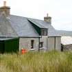
DP 047284
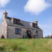
Inshore, shepherd's house, view from the east.
RCAHMS Field Survey Digital Photography
4/8/2008
© Crown Copyright: HES

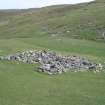
DP 047415
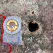
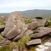
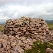
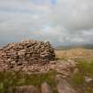
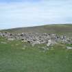
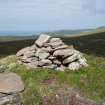
Cnoc a’ Ghiubhais, marker cairn, detail of ‘witter’ hole.
RCAHMS Field Survey Digital Photography
6/8/2008
© Crown Copyright: HES

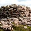
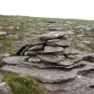
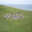
DP 047416
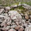
Cnoc a’ Ghiubhais, marker cairn, view of central boulder.
RCAHMS Field Survey Digital Photography
6/8/2008
© Crown Copyright: HES

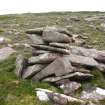
DP 047417
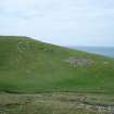
Cnoc an Daimh, marker cairn, view from the south-west.
RCAHMS Field Survey Digital Photography
6/8/2008
© Crown Copyright: HES

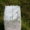
DP 047285
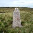
Dùnan Mòr, boundary stone, view of top of stone.
RCAHMS Field Survey Digital Photography
5/8/2008
© Crown Copyright: HES

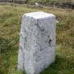
DP 047286
Dùnan Mòr, boundary stone, view from the south-east.
RCAHMS Field Survey Digital Photography
5/8/2008
© Crown Copyright: HES

DP 047287
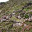
Allt na Clais Leobairnich, shieling huts, view from the north-west.
RCAHMS Field Survey Digital Photography
5/8/2008
© Crown Copyright: HES

DP 047288
Allt na Clais Leobairnich, shieling huts, view from the north-west.
RCAHMS Field Survey Digital Photography
5/8/2008
© Crown Copyright: HES

DP 047289
Allt na Clais Leobairnich, pen (CWTC08 016), view from the east.
RCAHMS Field Survey Digital Photography
5/8/2008
© Crown Copyright: HES

DP 047290
Allt na Clais Leobairnich, pen (CWTC08 016), view from the south.
RCAHMS Field Survey Digital Photography
5/8/2008
© Crown Copyright: HES

DP 047291
Allt na Clais Leobairnich, pen (CWTC08 016), view from the south-west.
RCAHMS Field Survey Digital Photography
5/8/2008
© Crown Copyright: HES

DP 047292
Bay of Keisgaig, hut (CWTC08 019), view from N.
RCAHMS Field Survey Digital Photography
5/8/2008
© Crown Copyright: HES

DP 047293
Bay of Keisgaig, hut (CWTC08 019), view from ENE.
RCAHMS Field Survey Digital Photography
5/8/2008
© Crown Copyright: HES

DP 047294
Bay of Keisgaig, hut (CWTC08 019), view from north-east.
RCAHMS Field Survey Digital Photography
5/8/2008
© Crown Copyright: HES

DP 047295
Bay of Keisgaig, hut (CWTC08 020), view from north-east.
RCAHMS Field Survey Digital Photography
5/8/2008
© Crown Copyright: HES

DP 047296
Bay of Keisgaig, hut (CWTC08 020), view from the north-east.
RCAHMS Field Survey Digital Photography
5/8/2008
© Crown Copyright: HES

DP 047297
Bay of Keisgaig, hut (CWTC08 020), view from the south-east.
RCAHMS Field Survey Digital Photography
5/8/2008
© Crown Copyright: HES

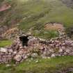
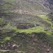
DP 047298
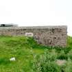
Bay of Keisgaig, building, view of SE end from the SW.
RCAHMS Field Survey Digital Photography
5/8/2008
© Crown Copyright: HES

DP 047299
Bay of Keisgaig, building, view from north-east.
RCAHMS Field Survey Digital Photography
5/8/2008
© Crown Copyright: HES

DP 047300
Bay of Keisgaig, building, view from the south-west.
RCAHMS Field Survey Digital Photography
5/8/2008
© Crown Copyright: HES

DP 047301
Bay of Keisgaig, building, view from south-east.
RCAHMS Field Survey Digital Photography
5/8/2008
© Crown Copyright: HES

DP 047302
Bay of Keisgaig, building, view from north-west.
RCAHMS Field Survey Digital Photography
5/8/2008
© Crown Copyright: HES

DP 047303
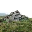
Cnoc an Daimh, marker cairn, view from N.
RCAHMS Field Survey Digital Photography
5/8/2008
© Crown Copyright: HES

DP 047304
Cnoc an Daimh, marker cairn, view from the south.
RCAHMS Field Survey Digital Photography
5/8/2008
© Crown Copyright: HES

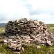
DP 047305
Cnoc a’ Ghiubhais, marker cairn and pen, view from the west.
RCAHMS Field Survey Digital Photography
5/8/2008
© Crown Copyright: HES

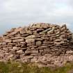
DP 047306
Cnoc a’ Ghiubhais, marker cairn, view from the ESE.
RCAHMS Field Survey Digital Photography
5/8/2008
© Crown Copyright: HES

DP 047307
Cnoc a’ Ghiubhais, marker cairn, view from north-east.
RCAHMS Field Survey Digital Photography
5/8/2008
© Crown Copyright: HES

DP 047308
Cnoc a’ Ghiubhais, marker cairn, view from the north-west.
RCAHMS Field Survey Digital Photography
5/8/2008
© Crown Copyright: HES

DP 047309
Cnoc a’ Ghiubhais, marker cairn, view from the north-west.
RCAHMS Field Survey Digital Photography
5/8/2008
© Crown Copyright: HES

DP 047310
Cnoc a’ Ghiubhais, marker cairn, view from the north-west.
RCAHMS Field Survey Digital Photography
5/8/2008
© Crown Copyright: HES

DP 047311
Cnoc a’ Ghiubhais, marker cairn, view from the south-west.
RCAHMS Field Survey Digital Photography
5/8/2008
© Crown Copyright: HES

DP 047312
Cnoc a’ Ghiubhais, marker cairn, view from the south-west.
RCAHMS Field Survey Digital Photography
5/8/2008
© Crown Copyright: HES

DP 047313
Cnoc a’ Ghiubhais, marker cairn, view from the north-east.
RCAHMS Field Survey Digital Photography
5/8/2008
© Crown Copyright: HES

DP 047314
Cnoc a’ Ghiubhais, marker cairn, view from the north.
RCAHMS Field Survey Digital Photography
5/8/2008
© Crown Copyright: HES

DP 047315
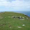
Am Bodach, enclosure, view from the ENE.
RCAHMS Field Survey Digital Photography
5/8/2008
© Crown Copyright: HES

DP 047316
Am Bodach, enclosure, view from the ESE.
RCAHMS Field Survey Digital Photography
5/8/2008
© Crown Copyright: HES

DP 047317
Am Bodach, enclosure, view from the north-east.
RCAHMS Field Survey Digital Photography
5/8/2008
© Crown Copyright: HES

DP 047318
Clais an Dùnain, shieling, view from the south-east.
RCAHMS Field Survey Digital Photography
5/8/2008
© Crown Copyright: HES

DP 047319
Clais an Dùnain, shieling, view from the south-west.
RCAHMS Field Survey Digital Photography
5/8/2008
© Crown Copyright: HES

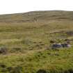
DP 047320
Clais an Dùnain, shieling, distant view from the south.
RCAHMS Field Survey Digital Photography
5/8/2008
© Crown Copyright: HES

DP 047321
Clais an Dùnain, shieling, distant view from the south-west.
RCAHMS Field Survey Digital Photography
5/8/2008
© Crown Copyright: HES

DP 047322
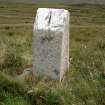
Dunan Mor, milestone, view from the north.
RCAHMS Field Survey Digital Photography
5/8/2008
© Crown Copyright: HES

DP 047323
Dunan Mor, milestone, view from the west.
RCAHMS Field Survey Digital Photography
5/8/2008
© Crown Copyright: HES

DP 047324
Sìthean na h-Iolaireach, marker cairn, view from the south-east.
RCAHMS Field Survey Digital Photography
5/8/2008
© Crown Copyright: HES

DP 047325
Sìthean na h-Iolaireach, marker cairn, view from the north-east.
RCAHMS Field Survey Digital Photography
5/8/2008
© Crown Copyright: HES


First 100 images shown.
