
Arran, Laggantuin


Byre Dwelling(S) (Post Medieval), Corn Drying Kiln (Post Medieval), Cruck Framed Building(S) (Post Medieval), Knocking Stone (Post Medieval), Lazy Beds (Post Medieval), Quarry Pit(S) (Post Medieval), Rig And Furrow (Post Medieval), Township (Post Medieval), Track (Post Medieval)
Site Name Arran, Laggantuin
Classification Byre Dwelling(S) (Post Medieval), Corn Drying Kiln (Post Medieval), Cruck Framed Building(S) (Post Medieval), Knocking Stone (Post Medieval), Lazy Beds (Post Medieval), Quarry Pit(S) (Post Medieval), Rig And Furrow (Post Medieval), Township (Post Medieval), Track (Post Medieval)
Alternative Name(s) Laggantuine; Laggantwine; Little Laggan
Canmore ID 70769
Site Number NR94NE 1
NGR NR 9988 4857
Datum OSGB36 - NGR
Permalink http://canmore.org.uk/site/70769


First 100 images shown. See the Collections panel (below) for a link to all digital images.
- Council North Ayrshire
- Parish Kilbride
- Former Region Strathclyde
- Former District Cunninghame
- Former County Buteshire
NR94NE 1 9965 4868
(Name: NR 9965 4868) Laggantuin (NAT)
OS 1:10,000 map, (1979)
Laggantuine (sic): the ruins of a 'runrig' clachan.
R McLellan 1977.
Centred NR 9975 4860. A deserted settlement occupying a large natural east-facing hollow above a coastal slope. The main building is 21m by 6m and has walls 0.8m thick with an average height of 1.5m. There are four other smaller ruinous buildings, the largest of which measures 15m by 4m. These buildings have a wall thickness of 0.8m and an average height of 1.3m. One has its north gable end still intact.
There are also four associated enclosures, of average dimension 40m, and a corn-drying kiln.
To the north, and still within the hollow, is an extensive area of rig and furrow and a number of ruined field walls.
On the coastal strip below the hollow is an area of stone clearance and fragmentary field walls. There are, however, no building remains to be seen.
Visited by OS (BS), 3 December 1977.
Note (2 July 2018)
The location, classification and period of this site have been reviewed.
HES Survey and Recording 2 July 2018
Field Visit (15 October 2019 - 16 October 2019)
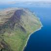
The ruined farm of Laggantuin, at one time a smallholding attached to North Sannox (NS04NW 17), is situated in a dramatic corrie of the same name on the NE coast of Arran. Served by a trackway that cuts obliquely up from the shore, the farmstead comprises at least three formerly thatched buildings (two of which are cruck-framed byre dwellings), three enclosures and a corn-drying kiln, all of which were abandoned in 1829. The arable land of the farm occupied the drier ground within the corrie and spilled onto the foreshore below, amounting to about 22 acres.
The range (A) consists of two attached dwellings that have been modified for use as sheepfolds. The larger structure (A1) is the remains of a byre-dwelling which measures about 15.6m from NE to SW by 6.2m over walls 0.7m thick and up to 3.5m in height at the NE gable. The walls are constructed of earth-bonded rubble with the occasional use of red sandstone at the margins. Particularly notable are the uppermost decorative quoins of the NE gable. The SE wall contains a single doorway, now partly blocked, a splayed window opening SW of the doorway, and there is some secondary lime mortar in the outer face. A cruck-slot is visible in the inner face immediately SW of the doorway. The NW wall has been largely rebuilt, but a small splayed window and a cruck-slot close to the NE end are original. The interior contains two stalls at the lower (NE) end and a central byre drain that exits below the gable. A partition wall has separated off a small room at the higher SW end, but the doorway that once linked the two compartments is now blocked, and the wall has been subsumed into a later sheep pen. The SW compartment (A2) is apparently the remains of a later dwelling about 5.4m in internal length. It has been robbed and modified after abandonment, but the SE wall contains a single original doorway and a possible cruck slot, while a low opening in the NW wall is a later sheep creep.
Immediately NW of the range (A) is a rectangular enclosure, most likely a sheepfold, which measures about 32m from NE to SW by 19m over the remains of a drystone wall that overlies the NW side of the range. This enclosure may stand on the footprint of an earlier one. Another fold, which lies immediately E of the range, measuring 22m from NW to SE by 18m overall and may be contemporary with it. The small high-walled fold immediately to the NE of the range is depicted on an estate map of 1812 as a roofed building (NRS: RHP 6663). A large boulder 14m NNE of building A (at NR 99898 48599), which has depression measuring 0.24m in diameter and 0.22m in depth in its upper surface, has probably seen use as a knocking stone.
A second building (B) stands about 30m to the south of A and is aligned across the slope from NNW to SSE. Rectangular on plan and formerly gabled, it measures 7m by 5m over earth-bonded rubble walls 0.65m thick and up to 2.6m height at the NNW gable. The remains of both a doorway and a splayed window-opening survive in the E wall suggesting that this building was once a dwelling, perhaps of a cottar. Another cruck-framed byre-dwelling (C) stands a further 15m to the SE and is aligned up-and-down the slope from E to W. Rectangular on plan it measures about 15.5m in length by up to 5.9m at the E end over rubble walls up to 0.75m thick and up to 1.8m high. The N wall is pierced by a single doorway, the remains of a splayed window-opening and a possible blocked cruck slot. The S wall contains another splayed window, probably inserted, and at least one cruck slot. The W end of the interior is choked with rubble, but the remains of later pen are visible; towards the E end are three edge-set slabs, marking cattle stalls, and a central drain that has exited below the gable.
Immediately SE of building C is an irregularly-shaped enclosure which is probably contemporary with the building’s use as a dwelling. It measures about 30m from WNW to ESE by 15m over a wall reduced to a stony bank that springs off the E gable of the building and is likely to have also been tacked onto its S side. This enclosure is overlain by a large oval enclosure measuring about 80m from E to W by 50m over a ruinous drystone wall. A small sheepfold is situated 10m to the E of building C (see NRS: RHP 6663).
A corn-drying kiln (D) stands 30m W of building A. Slightly oval on plan it measures 5.9m from N to S by 4.9m overall, with a bowl measuring 1.4m square by 1.1m in depth. A flue leads out to the N. A small lochan about 50m SW of building A may have been the farmsteads principal source of water.
The cultivation remains associated with the farm include both rig-and-furrow and lazy beds located in the flatter and drier patches of ground in the base of the corrie and along the sea shore. Stone cleared from the fields is found in both linear and circular clearance cairns, one focus of which lies about 75m NW of building A in wetter ground. Most of the cultivated ground is unenclosed, but stretches of turf-and-stone dykes are located about 100m SW of building A and at the NW edge of the corrie. Drainage ditches, some of which may be contemporary with the farmstead, survive 100m S of building A and 175m to the WSW. At least four shieling huts were recorded in the upper reaches of the corrie (e.g. NR94NE 59), and these might be contemporary with the farmstead or earlier.
One unusual feature of Laggantuin is the presence of numerous small circular quarry pits, averaging about 3m in diameter and 0.5m in depth found across the arable ground and within the farmstead. Many of these appear to be late in the sequence and two examples situated about 50m E of building A can be seen to cut into the trackway and a cultivation ridge respectively. These small quarries may have led to the area to the NW of the farmstead being labelled as disused workings on OS Mastermap (2014), but no remains of the ‘Laggantwain slate quarry’ noted in 1771 (Burrel’s Journal, 28 September 1771) were discovered.
Historical note
An indication of agricultural practice on Arran in the late 18th and early 19th century can be gleaned from general reviews such as Aiton (1816), Headrick (1807, 221, 309-315) and Paterson (1837) as well as the accounts of the parish by Stuart (Stat. Acct., 1793, viii, 578-592) and McNaughton (New Stat. Acct. 1845, v, 26, 28-32).
An estate map of Arran indicates that ‘Lagantuin’ was a pendicle (or smallholding) of North Sannox in the mid-18th century, possibly with only one building (NRS: RHP 6170). By 1772 the farm had been established as a single holding and the tenant, Robert Hendry, ‘repaired the farm house’ with timber from the estate woodland (Mackenzie 1914, 359; Burrell’s Journal v.1, p.190). In 1776 the farm was taken on a 19-year lease with North Sannox by Archibald and Malcolm McKenzie, and Malcolm Mackillop held the farm from 1795 until at least 1823 (information from Arran Museum volunteers). A more detailed estate map by Robert Bauchop dated 1812 depicted four buildings on the site (NRS: RHP 6663) and illustrated the distribution of arable (c.17 acres) and pasture (c.11 acres) associated with the farm. The last occupants of Laggantuin were among those on Arran who immigrated to Canada in the spring of 1829, at which time they numbered four families and a total of 23 individuals, each with the surname Brodie or Kelso (Mackenzie 1914, 216-226).
Visited by HES Archaeological Survey (G F Geddes, A T Welfare, G Brown) 15-16 October 2019.
Measured Survey (15 October 2019 - 16 October 2019)
The archaeological plan of Laggantuin township was developed using a variety of sources that included a 1:500 pencil drawing, HES dGPS survey data and UAV photography with ground control points, as well as airborne laser scan (ALS) data (from Scottish Public Sector LiDAR (Phase II) data*. In addition, colour orthophotographs taken in 2004 and 2010 (supplied by Getmapping), historic maps and documentary sources were consulted. The 1:1000 final plan has been archived as a Scalable Vector Graphics (SVG) file and as a layered PDF, which includes a steepness of slope background and contours.

