
Longannet Electricity Generating Station


Building(S) (20th Century), Bunker(S) (20th Century), Cottage (19th Century), Power Station (20th Century)
Site Name Longannet Electricity Generating Station
Classification Building(S) (20th Century), Bunker(S) (20th Century), Cottage (19th Century), Power Station (20th Century)
Alternative Name(s) Longannet Power Station
Canmore ID 68087
Site Number NS98NE 40
NGR NS 9520 8530
NGR Description Centred NS 9520 8530
Datum OSGB36 - NGR
Permalink http://canmore.org.uk/site/68087


First 100 images shown. See the Collections panel (below) for a link to all digital images.
- Council Fife
- Parish Tulliallan
- Former Region Fife
- Former District Dunfermline
- Former County Fife
NS98NE 40 centred 9520 8530
Longannet Power Station [NAT]
OS (GIS) MasterMap, April 2010.
For (integral) Longannet Colliery (centred NS 9450 8625), see NS98NW 65.
Not to be confused with (former) Kincardine Power Station (Kincardine Generating Station), centred at NS 9250 8810, for which see NS98NW 61.00.
Built 1966, by Robert Matthew, Johnson-Marshall & Partners, who also built Cockenzie Power Station (NT37NE 4).
J Gifford 1988
Site recorded by Maritime Fife during the Coastal Assessment Survey for Historic Scotland, Kincardine to Fife Ness 1996.
Standing Building Recording (January 2008)
NS 9499 8563 A desk-based assessment and a Level 2 standing building survey were undertaken in January 2008 on Longannet Power Station, Kincardine-on-Forth. The aim of the work was to record the remaining upstanding structures within the site boundary of the Proposed Biomass to Energy Plant. The structures consist of seven buildings and bunkers associated with WW2 defences and a small single-storey cottage with two outbuildings, which appear to date from the mid 19th century.
The work confirmed that little is known about the origins of Newpans cottage and the renovations carried out to the main structure. It is unclear whether the ancillary structures next to the cottage are also original, as the OS maps do not show a clear footprint of the site’s development. The remains of the munitions bunkers survive, but many of the original features have been removed and the structures have been vandalised.
Two of the structures next to the munitions bunkers were built later, as they sit over the earth banks that would have re-enforced the blast walls. Two of the structures are modern and of no architectural merit or historic value.
Archive: RCAHMS
Funder: Scottish Power
Kirsten Mckee (Jacobs UK), 2008
Field Visit (July 2016)
NS98NE 40 (NS9520 8530)
Longannet Power Station, Alloa, Fife
See also illustrated version: Longannet Electricity Generating Station Summary (file: WP00004474)
Summary record compiled as a result of a photographic survey carried out by Architecture and Industry, Survey and Recording Section, Heritage Directorate, HES, July 2016.
Background
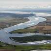
The largest of its kind in Europe when it was completed, Longannet was a thermal power station using coal to generate electricity. It was the largest generator of power in Scotland prior to its decommissioning on the 24th March 2016. It occupied an 89-hectare site on the north side of the Firth of Forth (partly on land reclaimed from the Firth of Forth using ash from the nearby Kincardine Power Station). (1)
The foundations of the power station run to 270 000 cubic metres of concrete. Most foundation work took place at the east end due to the dip in the rock. Large bore holes were created into which the concrete was poured. The main building contained 35 000 tonnes of steel including specialist steels to support the weight of the boilers (11 000 tonnes each). The lattice girder in the boiler suspension steelwork weighed in at 225 tonnes and carried a load of some 6 000 tonnes. (2)
Longannet Power Station came on line in 1969 although the planning, design and build had begun many years before (building had begun in 1961) and had a projected 30 year lifespan. It began to generate electricity in 1970 and by 1973 was fully operational. It was designed by the architects Robert Matthew, Johnson and Marshall and Partners and the consulting engineers were Mertz and McLellan. (3) It was operated by the South of Scotland Electricity Board (1973-1991) and then by Scottish Power (a subsidiary of Iberdrola) after privatisation of the UK electricity industry in 1990. (4)
Longannet was built with a capacity of 2400MW (although in reality the capacity was 2304MW) and represented more than half the generating ability capacity of all of the South of Scotland Electricity Board's other stations. Longannet produced 9,525 GW hours of electricity in 2012. (5) This was enough electricity for 2 million households.
Work on the construction of the access road to the station and on the excavations for the foundations of the main building was begun in January 1964. (6) The main building was 300m in length by 150m in width, rising to a height of 75m. The chimney was comprised of four 183m flues encased in a concrete windshield. (7)
Longannet Power Station was supplied by the Longannet Mine until 2002. The incoming coal was received in a system of three hoppers. Two of these were originally for coal from Longannet Mine and the third for the small amount arriving by road in the 1970s. Latterly coal was mostly supplied from abroad by ship via the British Steel terminal at Hunterston in Ayrshire and by rail from the rest of Scotland.
Scottish Power is currently decommissioning the site. The closure of Longannet Power Station marks the end of coal fired electricity production in Scotland.
Layout
Any coal -fired power station is made up of several components to enable the generation of electricity by burning coal namely: coal handling area, boiler house, turbine hall, switchgear, ash handling, chimney and cooling water circulation system.
Coal handling
Coal handling area was designed to handle upto 24,000 tonnes per day. The coal arrived on site (by ship and train) and was put into one of three hoppers for both road and rail. These are of different sizes. There was an exchange hopper that was built to take the Longannet Mine coal that was transferred into bunkers in the main boiler house by a 1.5km long conveyor. This conveyor carried 3,500 tonnes per hour. In addition, 2,000,000 metric tonnes of coal could be held in reserve in the coal yard (to the west of the power station site). (8) Longannet Power Station could use 4,500,000 metric tonnes (4,400,000 long tons or 5,000,000 short tons) of coal per year. The coal was brought on site, initially from Longannet Colliery, in bottom emptying railway coal wagons which unloaded automatically as they rolled through the site.
Boiler House
The coal was then taken by conveyor from the bunkers and pulverised or ground down into a powder by the vertical pulverising mills (see DP244006). There were 8 pulverisers for each of the four 64m high boilers in the boiler house. Each mill could handle 40 tonnes of coal per hour. The pulverised coal was then air-blown into the furnaces where it burned at very high temperature.
The four, front-wall fired Foster Wheeler Boilers (BOFA) were made up of many metal, water-filled tubes. The combusting coal powder below the boiler tubes send up hot gases which cause the water in the tubes to boil and produce steam. Each boiler had a steam drum into which the pressurized steam was fed. This steam then passed through a bank of steam tubes placed at the top and back of the boiler. The steam is then reheated to 568 degrees centigrade to be passed to the high pressure turbine cylinder. Each boiler could burn 250 tonnes of coal per hour. Each boiler had two forced and two induced draught fans. Gas was also used as a fuel in the boilers. (9)
Turbine Hall
Power at Longannet Power Station is from four 600MW (6,000,000-kilowatt) turbine -generators. Some 1800 tonnes of steam (see DP 243992) an hour per boiler was superheated to 586 degrees centigrade and piped (at at pressure of 168 bars) to the high pressure cylinders of two 300 MW GEC turbo generators (see DP 244007).
The turbine parallel rotors spun at 3000 r.p.m. each turning the electromagnet of a 300,000 -kilowatt electrical generator at the rate of 50 revolutions per minute. The rings of the blades of the rotors were divided between a number of cylinders which were interconnected by steam pipework. The steam expanded throughout the high pressure cylinder on one of the shafts and was then piped back to the boiler. It was then reheated to its original temperature and passed to the first of the two intermediate pressure cylinders both of which were on the other rotor.
From the second intermediate pressure cylinder, the steam flowed to the steam casings two of which were mounted on either shaft. Both the tow intermediate pressure and the four low pressure cylinders were of double flow design, where the steam entered at the centre and travelled to both ends of the casing. To allow for the expansion of the stream through the turbine, larger blades were used towards the low pressure end of the machine: the largest blades (914mm in length) were positioned before the eight exhausts of the low pressure cylinders.
Mounted below each pair of low pressure cylinders was a condenser (operating at high vacuum) which condensed steam into water which was then used as feed water for the boilers via feed heaters. These utilised the steam bled from various points on the turbine to heat it to the correct temperature. (10) The townswater supply was used for steam generation.
The Central Control Room was fitted with supervisory desks and it was from here that 'hot starts' and shut downs were controlled as well as normal everyday operation. When fitted, all of the control panels were had close circuit television for monitoring boiler drum water levels and fully automatic boiler control. The annex to the Control Room was from where communications for the power station were controlled along with the common electrical and mechanical services. There was also a control panel for the 275kV switchgear. (11)
The condensers used seawater from the Firth of Forth to cool the steam (see DP 244009 and DP 244010) with upto 327,000 cubic metres of water required per hour.This cooling water was then returned to the Firth of Forth via a 1.6km long channel which measured 38m in width (top) and 7.3m in depth. (12)
Switchhouse
The outputs of the two generators were combined at a generator transformer where the pressure of the electricity was raised from 17 kilovolts (kV) to 275 kilovolts (kV) before passing to an indoor switchhouse adjacent to the main building. This electricity was then fed into the National Grid via 275kV overhead lines to 275kV transforming and switching stations on the transmission system. (13)
Ash Handling
The generation of electricity from coal generates ash, dust and other emissions. The power station could produce up to 4350 tonnes of ash a day. Most of this was mixed with water and pumped to off-shore disposal lagoons at Valleyfield (some 5km distant) for land reclamation. (14) Electrostatic precipitators (refurbished 1989-1994) were used to capture dust particles (using plates with a static electricity charge) from the flue gases followed by sulphur trioxide equipment in the 1980s. Longannet was also fitted with a BOFA system (in 1994) to reduce nitrous oxide (NOx) emissions by injecting natural gas into the boiler and flue gas desulphurization (FGD) equipment was installed to reduce sulphur dioxide (SO2).
The fuel ash produced by the burning of the coal falls into two categories: pulverised fuel ash (PFA) removed by the electrostatic precipitators and furnace bottom ash (FBA from the boilers and sent to Settlement Ponds) which collected at the bottom of the boiler. Most of this ash was in the form of a fine dust (PFA) from the electrostatic precipitators. The rest of the ash (PFA and FBA) was transported to the storage lagoons at Valleyfield (east of the site). (15) Latterly, a company called ScotAsh (based at Longannet) made construction products from the ash on site. (16) The windshield or chimney is 183m (600 feet) in height and was the tallest concrete structure in Scotland when built. (17)
Cooling Water
When in operation, 636 cubic metres (3217 million litres) of water per hour was drawn through intake headworks 150m offshore in the River Forth. (18) The intake structure was of course screens to filter out matter and to protect the salmon smolt. Finer screening was carried out at the station pump house which was connected to vertical shafts and tunnels 11m below the riverbed.
The pump-bay of the Pump House contained 4 large electrically driven pumps, each with a capacity to pump 80 million litres of condenser cooling water per hour along 4 culverts (3.7m in diameter) to the condensers. (19)
References
(1) SSEB, Longannet Power Station, (c.1974), introduction (unpaginated)
(2) SSEB, Longannet Power Station, (c.1974),, 'cross section of station', (unpaginated)
(3) Gifford, J; McWilliam,C.E. and Walker, D , The Buildings of Scotland, Edinburgh, (London, 1988, 266)
(4) Information from Richard Christie of Scottish Power
(5) Scottish Power Longannet Power Station EMAS Statement (2014 )
(6) SSEB, Longannet Power Station, (March 1971), 10
(7) SSEB, Longannet Power Station, (March 1971), 10
(8) SSEB, Longannet Power Station, (c.1974), 'Coal Delivery System', (unpaginated)
(9) SSEB, Longannet Power Station, (c.1974), 'Boiler Plant', (unpaginated)
(10) SSEB, Longannet Power Station, (c.1974), 'Generating Units', (unpaginated)
(11) SSEB, Longannet Power Station, (c.1974), 'Control Room', (unpaginated)
(12) SSEB, Longannet Power Station, (c.1974), 'Outflow of Cooling Water', (unpaginated)
(13) SSEB, Longannet Power Station, (c.1974), 'Transmission', (unpaginated)
(14) SSEB, Longannet Power Station, (March 1971), 20
(15) SSEB, Longannet Power Station, (c.1974), 'P.F.A. Disposal', (unpaginated); Scottish Power, Longannet Power Station: site information http://www.scottishpower.com/userfiles/file/Longannet-Site-Information-2014.pdf [Retrieved: 21/11/2016]
(16) Information from Richard Christie or Scottish Power
(17) SSEB, Longannet Power Station, (March 1971), 11
(18) SSEB, Longannet Power Station, (March 1971), 18
(19) SSEB, Longannet Power Station, (March 1971), 18
Acknowledgement:
HES wishes to thank Mr Richard Christie of Scottish Power for giving his time and for sharing knowledge about Longannet Power Station during the Survey and Recording Section, Architecture and Industry survey team visit in July 2016.
Visited by Survey and Recording Section: Architecture and Industry, HES (Miriam McDonald), July 2016.
Photographic Survey (8 June 2016 - 9 June 2016)
This thermal (coal) electricity generating station ceased generation on the 24th March 2016. It is now undergoing decommissioning.
A photographic survey was undertaken by the Survey and Recording Section (Architecture and Industry) of Historic Environment Scotland, 8-9 June 2016 to enhance the record in HES site database, Canmore, for this site.
Information from HES (MMD, Survey and Recording Section), 16 June 2016

