|
Manuscripts |
MS 731/20 |
Records of the Royal Commission on the Ancient and Historical Monuments of Scotland (RCAHMS), Edinbu |
Afforestable Land Survey field database (Liddesdale survey, 1996). Held as attribute table in GIS and in Oracle Field/AP table. Please see DX001442 |
1996 |
Item Level |
|
|
Photographs and Off-line Digital Images |
D 46395 CN |
RCAHMS Aerial Photography |
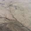
General oblique aerial view looking over the sheep stell towards the remains of the fort, palisaded enclosure, farmstead, cottage and sheepfold, taken from the WSW. |
27/3/2000 |
Item Level |
|
|
Photographs and Off-line Digital Images |
D 46396 CN |
RCAHMS Aerial Photography |
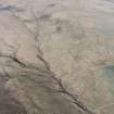
General oblique aerial view looking over the sheep stell towards the remains of the fort, palisaded enclosure, farmstead, cottage and sheepfold, taken from the SW. |
27/3/2000 |
Item Level |
|
|
Photographs and Off-line Digital Images |
D 46397 CN |
RCAHMS Aerial Photography |
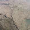
General oblique aerial view looking over the sheep stell towards the remains of the fort, palisaded enclosure, farmstead, cottage and sheepfold, taken from the SW. |
27/3/2000 |
Item Level |
|
 |
On-line Digital Images |
SC 1761477 |
RCAHMS Aerial Photography |
General oblique aerial view looking over the sheep stell towards the remains of the fort, palisaded enclosure, farmstead, cottage and sheepfold, taken from the WSW. |
27/3/2000 |
Item Level |
|
 |
On-line Digital Images |
SC 1761478 |
RCAHMS Aerial Photography |
General oblique aerial view looking over the sheep stell towards the remains of the fort, palisaded enclosure, farmstead, cottage and sheepfold, taken from the SW. |
27/3/2000 |
Item Level |
|
 |
On-line Digital Images |
SC 1761479 |
RCAHMS Aerial Photography |
General oblique aerial view looking over the sheep stell towards the remains of the fort, palisaded enclosure, farmstead, cottage and sheepfold, taken from the SW. |
27/3/2000 |
Item Level |
|
|
Digital Files (Non-image) |
DX 001442 |
Records of the Royal Commission on the Ancient and Historical Monuments of Scotland (RCAHMS), Edinbu |
RCAHMS Structures Database - Liddesdale survey |
1996 |
Item Level |
|
|
Digital Files (Non-image) |
TM 000559 |
Records of the Royal Commission on the Ancient and Historical Monuments of Scotland (RCAHMS), Edinbu |
Zip file containing all the survey linework collected during the RCAHMS Afforestable Land Survey of Liddesdale |
1996 |
Item Level |
|
 |
On-line Digital Images |
SC 2473033 |
Records of the Ordnance Survey, Southampton, Hampshire, England |
Puddingburn Tower, NY48NE 5, Ordnance Survey index card, page number 1, Recto |
c. 1958 |
Item Level |
|
 |
On-line Digital Images |
SC 2473034 |
Records of the Ordnance Survey, Southampton, Hampshire, England |
Puddingburn Tower, NY48NE 5, Ordnance Survey index card, page number 2, Verso |
c. 1958 |
Item Level |
|
|
Digital Files (Non-image) |
TM 002203 |
Records of the Royal Commission on the Ancient and Historical Monuments of Scotland (RCAHMS), Edinbu |
Zip file containing all the survey linework collected during the RCAHMS Afforestable Land Survey of Liddesdale. SHP and Geojson file formats with extra attribution added to the linework. |
1996 |
Item Level |
|
|
All Other |
551 166/1/1 |
Records of the Ordnance Survey, Southampton, Hampshire, England |
Archaeological site card index ('495' cards) |
1947 |
Sub-Group Level |
|


