
Eweslees Burn


Enclosure(S) (Period Unassigned), Rig And Furrow (Medieval) - (Post Medieval)
Site Name Eweslees Burn
Classification Enclosure(S) (Period Unassigned), Rig And Furrow (Medieval) - (Post Medieval)
Canmore ID 67752
Site Number NY39NE 14
NGR NY 381 982
NGR Description Centred NY 381 982
Datum OSGB36 - NGR
Permalink http://canmore.org.uk/site/67752


- Council Dumfries And Galloway
- Parish Ewes
- Former Region Dumfries And Galloway
- Former District Annandale And Eskdale
- Former County Dumfries-shire
NY39NE 14 centred 381 982
For hollow-ways (possibly representing an old or Roman road) through the area of these enclosures, see NY39NE 29.
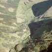
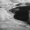
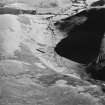
Extensive remains of rig-and-furrow cultivation (in part surrounded by earthen banks) and a several smaller enclosures, survive in unimproved ground towards the head of the Eweslees Burn.
Visited by RCAHMS (JRS), 4 August 1993.

