|
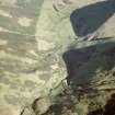
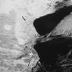
Photographs and Off-line Digital Images |
DF 3316 CS |
RCAHMS Aerial Photography |
Oblique aerial view. |
1980 |
Item Level |
|
|
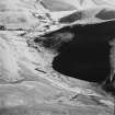
Photographs and Off-line Digital Images |
DF 3317 CS |
RCAHMS Aerial Photography |
Oblique aerial view. |
1980 |
Item Level |
|
|
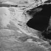
Photographs and Off-line Digital Images |
DF 3318 CS |
RCAHMS Aerial Photography |
Oblique aerial view. |
1980 |
Item Level |
|
|
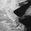
Photographs and Off-line Digital Images |
DF 3319 CS |
RCAHMS Aerial Photography |
Oblique aerial view. |
1980 |
Item Level |
|
|
Photographs and Off-line Digital Images |
D 86730 CS |
RCAHMS Aerial Photography |
Oblique aerial view of Ewes Doors centred on the remains of a possible Roman watch tower, linear earthworks, enclosures, rig and old roads, taken from the WNW. |
10/9/1997 |
Item Level |
|
|
Photographs and Off-line Digital Images |
D 20125 |
RCAHMS Aerial Photography |
Oblique aerial view of Eweslees Burn centred on the remains of enclosures, rig and old roads, taken from the NNW. |
10/9/1997 |
Item Level |
|
|
Photographs and Off-line Digital Images |
D 20126 |
RCAHMS Aerial Photography |
Oblique aerial view of Eweslees Burn centred on the remains of enclosures, rig and old roads, taken from the NW. |
10/9/1997 |
Item Level |
|
|
Photographs and Off-line Digital Images |
D 20127 |
RCAHMS Aerial Photography |
Oblique aerial view of Eweslees Burn centred on the remains of enclosures, rig and old roads, taken from the NW. |
10/9/1997 |
Item Level |
|
|
Photographs and Off-line Digital Images |
D 20128 |
RCAHMS Aerial Photography |
Oblique aerial view of Eweslees Burn centred on the remains of enclosures, rig and old roads, taken from the WNW. |
10/9/1997 |
Item Level |
|
 |
On-line Digital Images |
SC 1495804 |
RCAHMS Aerial Photography |
Oblique aerial view of the valley of the Eweslees burn with Ewes Doors in the foreground (c400m OD) and Eweslees farmstead in the distance (c200m OD) to the SE. The Roman watch tower is visible as a circular earthwork at the bottom of the image, and fragments of old trackways can be seen crossing the pass and heading into the valley below, while a series of linear earthworks run across the pass.
|
10/9/1997 |
Item Level |
|
 |
On-line Digital Images |
SC 1761349 |
RCAHMS Aerial Photography |
Oblique aerial view of Eweslees Burn centred on the remains of enclosures, rig and old roads, taken from the NNW. |
10/9/1997 |
Item Level |
|
 |
On-line Digital Images |
SC 1761350 |
RCAHMS Aerial Photography |
Oblique aerial view of Eweslees Burn centred on the remains of enclosures, rig and old roads, taken from the NW. |
10/9/1997 |
Item Level |
|
 |
On-line Digital Images |
SC 1761380 |
RCAHMS Aerial Photography |
Oblique aerial view of Eweslees Burn centred on the remains of enclosures, rig and old roads, taken from the NW. |
10/9/1997 |
Item Level |
|
 |
On-line Digital Images |
SC 1761381 |
RCAHMS Aerial Photography |
Oblique aerial view of Eweslees Burn centred on the remains of enclosures, rig and old roads, taken from the WNW. |
10/9/1997 |
Item Level |
|
 |
On-line Digital Images |
SC 2472822 |
Records of the Ordnance Survey, Southampton, Hampshire, England |
Eweslees Burn, NY39NE 14, Ordnance Survey index card, Recto |
c. 1958 |
Item Level |
|
|
Photographs and Off-line Digital Images |
SC 2836404 |
RCAHMS Aerial Photography |
Oblique aerial view of Ewes Doors centred on the remains of a possible Roman watch tower, linear earthworks, enclosures, rig and old roads, taken from the WNW. |
10/9/1997 |
Item Level |
|


