
Arresgill


Farmstead (Medieval) - (Post Medieval)
Site Name Arresgill
Classification Farmstead (Medieval) - (Post Medieval)
Canmore ID 67737
Site Number NY38SW 32
NGR NY 31096 84646
Datum OSGB36 - NGR
Permalink http://canmore.org.uk/site/67737


- Council Dumfries And Galloway
- Parish Langholm
- Former Region Dumfries And Galloway
- Former District Annandale And Eskdale
- Former County Dumfries-shire
Field Visit (March 1981)
Arresgill NY 311 846 NY38SW
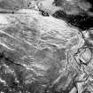
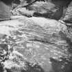
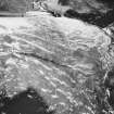
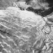
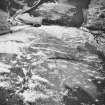
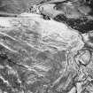
On a steep E-facing slope 200m SSW of Arresgill there is a group of four platform buildings varying in size from 5m by 2m to 10.4m by 2.9m internally. Immediately N of the buildings there are traces of a slightly scopped yard and a further rectangular building measuring 10.6m by 3.9m internally.
RCAHMS 1981, visited March 1981
Measured Survey (17 June 1992 - 18 June 1992)
RCAHMS surveyed the farmstead at Arresgill between 17-18 June 1992 with plane-table and self-reducing alidade at a scale of 1:250. This plan was redrawn in ink for publication at a scale of 1:1000 (RCAHMS 1997, Fig. 257).
Note (1997)
NY 3110 8465 NY38SW 32
Listed as farmstead.
RCAHMS 1997.

