
Pricing Change
New pricing for orders of material from this site will come into place shortly. Charges for supply of digital images, digitisation on demand, prints and licensing will be altered.
Wamphray Place


Building(S) (Medieval) - (Post Medieval), Earthwork(S) (Medieval) - (Post Medieval), Motte And Bailey (Medieval)
Site Name Wamphray Place
Classification Building(S) (Medieval) - (Post Medieval), Earthwork(S) (Medieval) - (Post Medieval), Motte And Bailey (Medieval)
Alternative Name(s) Leithenhall; Wamphray Glen; Wamphray Motte; Mount
Canmore ID 66922
Site Number NY19NW 8
NGR NY 12837 96501
Datum OSGB36 - NGR
Permalink http://canmore.org.uk/site/66922


- Council Dumfries And Galloway
- Parish Wamphray
- Former Region Dumfries And Galloway
- Former District Annandale And Eskdale
- Former County Dumfries-shire
NY19NW 8 1282 9648.
(NY 1282 9648) Wamphray Place (NR) (Site of).
(NY 1284 9652) Mount (NR).
OS 6" map, (1958)
Foundations of rectangular structures, and low banks mark the site of the ancient Wamphray Place (RCAHMS 1920) or Leithenhall. (Name Book 1857)
Also on the site, on the edge of the glen to the E, is an artificial flat-topped mound, from 11 to 13ft high, which is described by the RCAHMS as '... evidently the remains of a mote ...', by Feachem as 'Motte', (R W Feachem 1956 ) and is scheduled as a 'Mote'. The ONB, however, says '... not used for the administration of justice but merely as a mount for a signal-flag-post ... Mount, not Moat, is the most approved designation ...'. (Name Book 1857)
RCAHMS 1920, Name Book 1857, R W Feachem 1956
A small piece of wall is all that now survives of the 'Auld Castle' of the Johnstones, lairds of Wamphray from 1476 till 1746. In 1747 the estate was sold and the 'Place' or Wamphray House was never again inhabited and gradually fell into ruin and eventually the stones were removed for building purposes. The only vestige remaining is a small piece of wall on the edge of a precipice. The site has been occupied since the 12th C.
Paterson 1906
There are grass-covered foundations of various rectangular buildings at this site and the walls of one at the S end of the promontory are c.1.9m wide; probably the remains of the 'Auld Castle' (? a tower) of the Johnstones. The remaining buildings are probably contemporary. Traces of a slight stone wall skirts the E and S sides of the site, and to the west are several small possibly medieval field enclosures. The mound at the N end is almost certainly the much-reduced remains of a motte while the later buildings appear to stand on a bailey. Names not confirmed. Resurveyed at 1:2500.
Visited by OS (R D) 24 March 1972
No change to previous field report.
Visited by OS (T R G) 31 August 1978
Measured Survey (14 May 1990 - 15 May 1990)
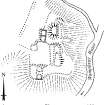
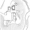
RCAHMS surveyed the motte and bailey at Wamphray Place between 14-15 May 1990 with plane-table and self-reducing alidade at a scale of 1:500. The plan was redrawn in ink and published at a scale of 1:1000 (RCAHMS 1997, Fig. 224). An inked version was also produced and published at a scale of 1:2500 alongside comparative plans of mottes and medieval earthwork monuments (RCAHMS 1997, Fig. 202).
Field Visit (16 May 1990)
NY 1282 9648 NY19NW 8
This motte-and-bailey castle is situated on the W edge of Wamphray Glen. The motte, which has probably been fashioned from a natural mound, stands to a height of 4.5m, but has been partially eroded on the E leaving a D-shaped summit area measuring 8.7m by 5.8m; at the base of the motte on the NE and the S there is a ditch (5m broad and 1m deep). The bailey lies to the S, and is defined on the E and S by the steep slopes of Wamphray Glen, but on the W only by a slight rise in ground level. Within the bailey there are the remains of two buildings, which are of two-compartment form and largely turf-covered. That on the N measures 24.7m by 8.3m overall. That in the SW corner measures 16.2m by 6.4m overall, its mortared S wall standing to a height of 1.3m, and is adjoined on the W by a small enclosure. A third building of two-compartment form lies at the base of the motte on the SW; it measures 13.4m by 6.3m over mortared stone walls 0.7m high, whilst to its SW there is a rectangular platform measuring 6.1m by 5.7m. Wamphray was held by the Corrie family until 1357 when it passed to Roger Kirkpatrick. By 1476 it was in the hands of the Johnstones who sold it to the Earl of Hopetoun in 1747, at which date the site probably went out of use.
Visited by RCAHMS (PC) 16 May 1990.
Listed as motte-and-bailey.
RCAHMS 1997.

