
Pricing Change
New pricing for orders of material from this site will come into place shortly. Charges for supply of digital images, digitisation on demand, prints and licensing will be altered.
Altanduin


Broch (Iron Age)(Possible), Building(S) (Medieval) - (18th Century)
Site Name Altanduin
Classification Broch (Iron Age)(Possible), Building(S) (Medieval) - (18th Century)
Alternative Name(s) Allt An Duin 2
Canmore ID 6692
Site Number NC82NW 4
NGR NC 8097 2605
Datum OSGB36 - NGR
Permalink http://canmore.org.uk/site/6692


- Council Highland
- Parish Kildonan
- Former Region Highland
- Former District Sutherland
- Former County Sutherland
NC82NW 4 8097 2605.
(NC 8097 2605) Broch (NR) (Site of)
OS 6"map, (1962)
The site of a broch, the walls of which had been removed by 1871.(Name Book 1871) The remains are now considerably mutilated with some large stones lying about, but the broch may have measured about 18m in diameter within the outer wall-faces. The site is defended on the west by an arcing double ditch with medial rampart. The inner ditch is 8m wide and 2m deep, and is well-preserved, as is the rampart. The slighter outer ditch is not mentioned by RCAHMS. (RCAHMS 1911, visited 1909)
Visited by OS (WDJ) 25 May 1961
No change to previous field report.
Visited by OS (JB) 7 February 1977
Field Visit (4 May 1991)
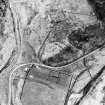
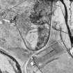
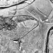
Occupying the NE end of a steep-sided promontory to the NE of the roofed buildings at Altanduin, there are the remains of a broch and its outworks. The broch measures about 9m in diameter within a wall (up to 4m in thickness) which has been reduced by stone-robbing to little more than a stony mound, with a number of possible outer facing-stones visible on the E and W. The neck of the promontory has been protected by a series of outworks, comprising two ditches and a medial wall interrupted by a causeway for the entrance. The outworks are best preserved on the SW, where the inner ditch measures up to 7.5m in width and 3m in depth; on the SE there is now no trace of the outer ditch and the wall has been wasted, but a number of possible outer-facing stones to the N of the broch suggest that, originally, it may have formed a continuous line of defence around the broch. To the E of the broch and within the line of the inner ditch there are the poorly defined footings of a rectangular building. Lying outside the outworks, to the SSW of the broch and roughly parallel to the track from Altanduin there is a rectangular building measuring 33m from NE to SW by 3.8m transversely within a stony bank 1.2m in thickness and 0.3m in height. The building has been partially robbed and it may incorporate more than one compartment.
(KILD91 470)
Visited by RCAHMS (DCC) 4 May 1991.
Publication Account (2007)
NC82 1 ALLT an DUIN 2 (‘Altanduin’)
NC/8097 2605
Site of possible broch or ditched home-stead in Kildonan, Sutherland, which had been demolished by 1871 [1]; it is now a heap of stones, doubtless having been robbed to build the recent longhouses nearby [3]. Although there are some large stones which may be from the bottom of the outer face of a broch wall “there is no surviving evidence that a broch was located at this site” [3]. On the west there are outer defences consisting of a curved double ditch with two ramparts but how these defences continue around the site is not clear [3].
Sources: 1. NMRS site no. NC 82 NW 4: 2. RCAHMS 1911a, 106, no. 313: 3. Swanson (ms) 1985, 807 - 09 and plan: 4. RCAHMS 1993.
E W MacKie 2007
Note (9 February 2015 - 31 May 2016)
The robbed broch on the steep-sided promontory overlooking the haughland at the confluence of Allt an Duin and Abhainn na Frithe stands within an outer defence drawn across the approach from the SW. The broch is little more than a stony mound, but the outer defences, where they are best preserved on the SW, comprise two ditches with a medial stone-faced rampart; the inner ditch is up to 7.5m in breadth by 3m in depth, and there is an entrance causeway on the S, beyond which on the SE the outer ditch disappears and the rampart has been severely reduced. A few possible facing stones on the N led an RCAHMS investigator in 1991 to suggest that the outer rampart may originally have encompassed the whole broch. Be that as it may an irregular area on the crest of the promontory, measuring up to 38m from NE to SW by 30m transversely (0.08ha), is cut off behind the defences on the SW. A later rectangular building has been constructed between the broch and the lip of the inner ditch on the E.
Information from An Atlas of Hillforts of Great Britain and Ireland – 31 May 2016. Atlas of Hillforts SC2806

