Kinbrace Hill
Chambered Cairn (Neolithic)
Site Name Kinbrace Hill
Classification Chambered Cairn (Neolithic)
Canmore ID 6647
Site Number NC82NE 2
NGR NC 8688 2935
Datum OSGB36 - NGR
Permalink http://canmore.org.uk/site/6647
- Council Highland
- Parish Kildonan
- Former Region Highland
- Former District Sutherland
- Former County Sutherland
NC82NE 2 8688 2935.
(NC 8688 2935) Chambered Cairn (NR). (SUT 35)
OS 6" map, 1962
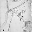
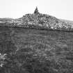
A large and apparently intact, round, chambered cairn of bare stones whose only disturbance appears to have been on the east and SE sides. The diameter is about 87' E-W by 83', and the height at least 9'. It appears to have been built on a platform, since a level area of turf-covered cairn material stretches out for 22' from the base, and beyond this heather is growing. A little inside the ESE edge of the cairn, two large upright slabs are set 1' 3" apart and appear to be the portals at the entrance to the passage.
(A S Henshall 1963; RCAHMS 1911, visited 1909; Visited by OS (EGC) 25 May 1961).
No change to previous reports.
Revised at 1/10,000
Visited by OS (J B) 11 January 1977
Field Visit (31 July 1991)
A large round cairn in a clearing in the forest measures about 17m from N to S and 12.7m transversely with a height of some 3.2m. The cairn appears to have been set on a low platform extending some 6.5m from the base. Two large upright stones can be seen a little within the ESE edge of the cairn, the more northerly measuring 0.7m by 0.33m and 1.35m in height with the more southerly 0.35m by 0,33m and 1.12m in height. The slabs are some 0.38m apart with their faces at an angle to one another; they do not appear to be kerbstones, and are more likely to form the portals at the entrance to a passage.
Visited by RCAHMS (JNGR and DCC) 31 July 1991


