
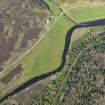
Suisgill


Souterrain (Prehistoric)
Site Name Suisgill
Classification Souterrain (Prehistoric)
Canmore ID 6638
Site Number NC82NE 11
NGR NC 8917 2511
Datum OSGB36 - NGR
Permalink http://canmore.org.uk/site/6638


- Council Highland
- Parish Kildonan
- Former Region Highland
- Former District Sutherland
- Former County Sutherland
NC82NE 11 8917 2511.
(NC 8917 2511) Earth House (NR).
OS 6" map, (1962)
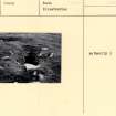
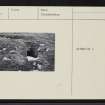
The remains of a souterrain on a level meadow. The passage is visible for a distance of 24' curving to give a chord of 19' between the extremities on the inner side. It is 2'6" to 3' with built sides and slab roof. In two places the roof slabs have been removed and the interior is largely filled with earth and stone. Neither extremity is open.
RCAHMS 1911, visited 1909.
A B Scott 1899
This souterrain is as described by the RCAHM.
Visited by OS (E G C) 31 May 1961
No change to previous field report; there is no trace of an associated hut circle.
Visited by OS (J B) 2 December 1976
Field Visit (6 June 1991)
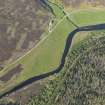
This souterrain is situated on the improved haugh-land on the N side of the River Helmsdale. It is banana-shaped on plan and measures 10m across the chord; the passage is 0.8m wide and at the SE end, where the roof-slabs survive, stands to a height of 0.55m.
(KILD91 379)
Visited by RCAHMS (DCC) 6 June 1991.

