|
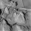
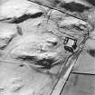
Photographs and Off-line Digital Images |
E 13766 |
RCAHMS Aerial Photography |
Oblique aerial view centred on the remains of the tower-house, enclosure and farmstead, taken from the WNW. |
26/3/2002 |
Item Level |
|
|
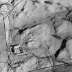
Photographs and Off-line Digital Images |
E 13767 |
RCAHMS Aerial Photography |
Oblique aerial view centred on the remains of the tower-house, enclosure and farmstead, taken from the S. |
26/3/2002 |
Item Level |
|
|
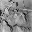
Photographs and Off-line Digital Images |
E 13768 |
RCAHMS Aerial Photography |
Oblique aerial view centred on the remains of the tower-house, enclosure and farmstead, taken from the SE. |
26/3/2002 |
Item Level |
|
|
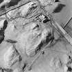
Photographs and Off-line Digital Images |
E 13769 |
RCAHMS Aerial Photography |
Oblique aerial view centred on the remains of the tower-house, enclosure and farmstead, taken from the ENE. |
26/3/2002 |
Item Level |
|
 |
On-line Digital Images |
SC 1365801 |
RCAHMS Aerial Photography |
Oblique aerial view centred on the remains of the tower-house, enclosure and farmstead, taken from the S. |
26/3/2002 |
Item Level |
|
|
Manuscripts |
MS 36/48 |
Records of the Royal Commission on the Ancient and Historical Monuments of Scotland (RCAHMS), Edinbu |
Field notebook of A L MacGibbon ? (RCAHMS): Berwickshire, Dumfriesshire, Midlothian. Includes measured sketches. |
10/6/1910 |
Item Level |
|
 |
On-line Digital Images |
SC 1759367 |
RCAHMS Aerial Photography |
Oblique aerial view centred on the remains of the tower-house, enclosure and farmstead, taken from the WNW. |
26/3/2002 |
Item Level |
|
 |
On-line Digital Images |
SC 1759368 |
RCAHMS Aerial Photography |
Oblique aerial view centred on the remains of the tower-house, enclosure and farmstead, taken from the S. |
26/3/2002 |
Item Level |
|
 |
On-line Digital Images |
SC 1759369 |
RCAHMS Aerial Photography |
Oblique aerial view centred on the remains of the tower-house, enclosure and farmstead, taken from the SE. |
26/3/2002 |
Item Level |
|
 |
On-line Digital Images |
SC 1759370 |
RCAHMS Aerial Photography |
Oblique aerial view centred on the remains of the tower-house, enclosure and farmstead, taken from the ENE. |
26/3/2002 |
Item Level |
|
 |
On-line Digital Images |
SC 2469706 |
Records of the Ordnance Survey, Southampton, Hampshire, England |
Holmains Tower, NY07NE 7, Ordnance Survey index card, page number 1, Recto |
c. 1958 |
Item Level |
|
 |
On-line Digital Images |
SC 2469707 |
Records of the Ordnance Survey, Southampton, Hampshire, England |
Holmains Tower, NY07NE 7, Ordnance Survey index card, Recto |
c. 1958 |
Item Level |
|
 |
On-line Digital Images |
SC 2469708 |
Records of the Ordnance Survey, Southampton, Hampshire, England |
Holmains Tower, NY07NE 7, Ordnance Survey index card, page number 2, Verso |
c. 1958 |
Item Level |
|
|
All Other |
551 166/1/1 |
Records of the Ordnance Survey, Southampton, Hampshire, England |
Archaeological site card index ('495' cards) |
1947 |
Sub-Group Level |
|


