
Pricing Change
New pricing for orders of material from this site will come into place shortly. Charges for supply of digital images, digitisation on demand, prints and licensing will be altered.
Scheduled Maintenance Notice
Please be advised that this website will undergo scheduled maintenance starting on Thursday, 30th January at 11:00 AM and will last until Friday, 31st January at 10:00 AM.
During this time, the site and certain functions may be partially or fully unavailable. We apologise for any inconvenience this may cause.
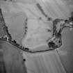
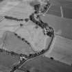
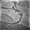
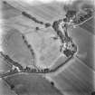
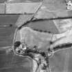
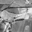
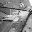
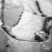
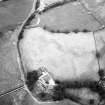
Gallaberry


Temporary Camp (Roman)
Site Name Gallaberry
Classification Temporary Camp (Roman)
Alternative Name(s) West Gallaberry
Canmore ID 65848
Site Number NX98SE 4
NGR NX 96360 82720
NGR Description Centred NX 96360 82720
Datum OSGB36 - NGR
Permalink http://canmore.org.uk/site/65848


- Council Dumfries And Galloway
- Parish Kirkmahoe
- Former Region Dumfries And Galloway
- Former District Nithsdale
- Former County Dumfries-shire
NX98SE 4 centred 96360 82720
See also NX98SE 45, NX98SE 50, NX98SE 51.
Published as Camp (R) (Site of) (1948);
Roman Camp (R) (site of), Fort (NR) (site of) (1969)
OS 1948; OS 1969.
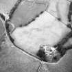
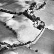
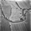
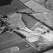
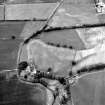
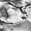
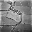
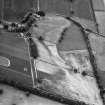
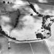
A Roman temporary camp was visible in parchmarks in June 1939. The camp, 1 1/3 acres in extent, is situated on a gravel terrace behind the farm buildings of W Gallaberry (NX98SE 69). Excavations carried out by St Joseph in 1952 established that the camp measured 64m by 110m, with an entrance 6m wide in the S side.
O G S Crawford 1939; J K St Joseph 1952
There are no surface indications of these features and the area is under pasture at present.
Visited by OS 1964
Publication Account (17 December 2011)
Discovered in 1939 by Crawford on one of his seminal flights into Scotland (see Chapter 4), the cropmark camp at Gallaberry lies on level ground about 1km east of the River Nith and less than 3km south-east of the fort and camps at Dalswinton. The camp is a parallelogram in form, measuring 109m from south-west to north-east by 61m, enclosing 0.67ha (1.7 acres). An entrance gap is visible in the south-west side and a further break can be seen in the south-east side, but this is not clearly an entrance. Excavations in 1939 by St Joseph recorded that the ditch was V-shaped, about 3.35m wide and 1.4m deep (Taylor 1940: 162; St Joseph 1952b: 120–2). The site overlies a probable Neolithic cursus monument and is close to a small prehistoric fort.
R H Jones
Aerial Photographic Transcription (8 June 2012)

