
Southwick Church


Burial Ground (Medieval), Church (13th Century)
Site Name Southwick Church
Classification Burial Ground (Medieval), Church (13th Century)
Alternative Name(s) Southwick Old Church And Churchyard
Canmore ID 65400
Site Number NX95NW 3
NGR NX 90645 56945
Datum OSGB36 - NGR
Permalink http://canmore.org.uk/site/65400


- Council Dumfries And Galloway
- Parish Colvend And Southwick
- Former Region Dumfries And Galloway
- Former District Stewartry
- Former County Kirkcudbrightshire
NX95NW 3 90645 56945
(NX 9064 5694) Southwick Church (NR) (Rems. of)
OS 6" map (1946)
For (successor and present) Parish Church (NX 92734 57373), see NX95NW 23.
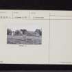
The original church appears to have been dedicated to 'Our Lady of Southwick' in the 13th c., but the existing fragment has been much altered, if not rebuilt, in post-Reformation times.
The remains are oblong in plan, measuring 62'6" by 26'3" over walls from 3'3" to 4' thick and about 12' in height. There are rough openings in the north wall; and the east half of the south wall has been demolished.
RCAHMS 1914, visited 1911
The fragmentary remains of this church are generally as described above. There are modern breaks at the west end of each lateral wall.
Visited by OS (JTT) 10 August 1965.
Burial ground depicted on the 1st edition of the OS 6-inch map (1854). Current extent of graveyard defined / digitized from orthoimagery provided by Bluesky International Ltd. OS 1km map square NX9056 (Core ID 4905649) flown on 3 April 2023.
Information from HES (C DeDeo) 20 March 2024

