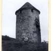
Clynekirkton, Parish Church, Bell Tower
Bell Tower (17th Century)
Site Name Clynekirkton, Parish Church, Bell Tower
Classification Bell Tower (17th Century)
Alternative Name(s) West Clyne; Old Parish Church; Clynekirkton, Belfry Tower
Canmore ID 6455
Site Number NC80NE 13
NGR NC 89438 06094
Datum OSGB36 - NGR
Permalink http://canmore.org.uk/site/6455
- Council Highland
- Parish Clyne
- Former Region Highland
- Former District Sutherland
- Former County Sutherland
NC80NE 13 89438 06094
(NC 8943 0609) Belfry (NR)
OS 6" map, (1964)
For (associated) Clynekirkton parish church, Pictish symbol stones and cross-slab (NC 8946 0607) and manse (NC8947 0602), see NC80NE 17.00 and NC80NE 39 respectively.
This circular bell-tower, one of only three remaining in Scotland, stands on a knoll a few yards from the old church (NC80NE 17). On harled rubble, it is 11ft 5ins high to the eaves, 5ft 3ins in diameter internally and about 10ft externally. The slated, conical roof formerly had two lucarne openings. The tower may date like the church from the 18th century, and was in use until 1825.
D MacGibbon and T Ross 1887-92; RCAHMS 1911, visited 1909; G Hay 1957.
The belfry tower is as described above. The architectural style suggests a 17th century date and it may have been built when the nearby old church was repaired in 1625-6. The tower stands on a mound, wholly or partly artificial, which is revetted on the N side.
Visited by OS (E G C), 17 July 1961.
No change to report of 17 July 1961.
Visited by OS (J B), 11 November 1975.
Field Visit (9 June 1909)
22. Belfry Tower, Clynekirkton. Situated on the top of a knoll some 12' to 13' high, to the NW. of the church at Clynekirkton, is a small circular tower some 29' in circumference and about 10' in height to the base of its conical roof and 14' to the apex, pierced with small square openings at the top of the wall. Before the present roof was put on, the belfry had two large square apertures opposite each other in the roof. The present square openings beneath the roof were the recesses for the beam ends connected with the support of the bell.
See Cast. and Dom. Arch., v. p. 221.
OS 6-inch map, Sutherland, Sheet xcviii.
RCAHMS 1911, visited (AOC) 9th August 1909.
Photographic Survey (November 1963)
Photographic survey by the Scottish National Buildings Record/Ministry of Works in November 1963.


