
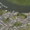
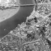
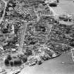
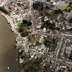
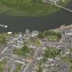
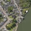
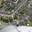
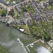
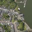
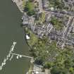
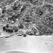
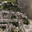
Kirkcudbright Harbour


Harbour (Period Unassigned)
Site Name Kirkcudbright Harbour
Classification Harbour (Period Unassigned)
Alternative Name(s) Kirkcudbright Creek; Kirkcudbright Quay; River Dee
Canmore ID 64126
Site Number NX65SE 81
NGR NX 6835 5115
Datum OSGB36 - NGR
Permalink http://canmore.org.uk/site/64126


- Council Dumfries And Galloway
- Parish Kirkcudbright
- Former Region Dumfries And Galloway
- Former District Stewartry
- Former County Kirkcudbrightshire
NX65SE 81.00 6835 5115
Kirkcudbright Harbour [NAT] (centred NX 6818 5117)
OS 1:10,000 map, 1990.
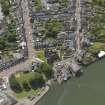
NX65SE 81.01 NX 68373 51120 Wet Dock ('Harbour')
NX65SE 81.02 NX 68375 51174 Pier ('Landing Stage')
NX65SE 81.03 NX 68357 51156 Quay
NX65SE 81.04 NX c. 683 512 Light (Beacon)
See also:
NX65SE 28 NX 68237 51068 Kirkcudbright Castle (Maclellan's Castle)
NX65SE 115 NX 68421 21257 Kirkcudbright Bridge
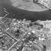
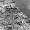
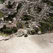
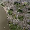
(Location cited as NX 68 51). Kirkcudbright. The former 'haven' of Kirkcudbright is today represented by a straight stretch of quay-wall, which forms the facing of the left bank of the Dee for a length of 175yds [160.1m]; but this arrangement only marks the final stage in a longish process of evolution.
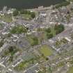
The medieval town (NX65SE 67) occupied a raised gravel ridge, bordered on the N by the river and partially encircled on the E and SE by a tidal creek and its associated streamlets and marsh. The resulting semi-insular site bore, at some probably near what is now the N end of the High Street, a motte (NX65SE 40), of which no material remains survive in a recognisable form, though its memory is perpetuated by the place-name 'Mote Brae' [name: NX 6831 5109]. The site was suitable for a stronghold, as it combined good water-defences, some sort of sheltered landing-place at the mouth of the creek, and control of the only ford across the lower Dee. Another feature of the Mote Brae site which concerns the harbour's history is the vanished Greyfriars Convent (NX65SE 41), founded there about 1455, the wall of whose graveyard evidently ran close beside the riverbank. In 1569 the Friary lands and church were granted by the King to Sir Thomas Maclellan of Bombie, who handed them over to the Town, the church becoming the town's parish church in the following year.
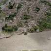
It is desirable to consider the position and extent of the tidal creek, as this has had a great deal of influence on the harbour's development. From plans [late 18th century, mainly by Gillone] preserved in the Stewartry Museum, it is clear that before about 1780, or even perhaps a few years later, the creek ran well inland past the E sector of the Mote Brae, forming, with its associated swamp-land, a kind of finger bounded on the W by the slope below the Castle Street gardens, as these now exist, and on the E by the rose to the modern parish church of St Cuthbert. Further NE again, the marshes covered what is now the E part of St Cuthbert Street, virtually as far as its junction with Millburn Street. A property known as Creikheid is recorded hereabouts at least as early as the middle of the 17th century. Information supplied by Mr ALD Bowick (formerly the Burgh Surveyor) is to the effect that effect that the whole of these waterlogged areas was drained by a system of conduits, which converged on a brick-built gathering-pit at the foot of a finger-like hollow just mentioned, and was discharged thence into the harbour. Since the filling-up of the harbour basin, the sewer has been prolonged and now opens straight into the Dee. The result of the subsistence caused by this underground water and the gathering-pit can be seen in the sagging of the roof-line and the distortion of a fanlight and string-course at nos. 18-22 St Cuthbert Street. The road leading from Millburn to the creek crossing, on the way to the church and castle, was known as the Creik Gait, and it conformed to the natural conditions by following a slightly sinuous course through the ground just N of St Cuthbert Street; this latter, slightly aligned from end to end as we see it now, represents the older road in a rationalised form, and must be classed, like St Mary Street and Castle Street, as an improvement dating from the end of the 18th century. The Creik Gait is mentioned in the Town records as least as early as 1588.
Evidence for the creek having functioned as an enclosed harbour has been seen in an English military intelligence report dated on internal evidence to the years 1563-5, which states that 'at full sea thei [ships] may pas up and lye at all times under the freres of the town' but this pretty certainly implies no more than that ships habitually tied up, or grounded, below the NW sector of the Friary's graveyard, and not that they entered the creek and moored by the graveyard's E sector. This interpretation of the passage is supported by the Town Council records of the 17th century, which consistently refer to 'the shore', 'the Moit' (1611), or 'the Moit wall' (1640), the last word being spelt 'woll', an old Scots form of 'well', which has persisted in the modern name of Motewell House, but apparently never to the creek, as the place where ships were handled. Again in 1656 and 1657 it is 'shore-masters', not 'harbour-masters', whose appointments are recorded. Nor need the language of the Town's application (1608) for help in the 'raparatioun of their heavin and mott' nor a reference (1641) to the 'harborie' necessarily apply to the creek rather than to river-bank wharfage or to a foreshore kept in a suitable state for ships to take the ground. At rather later dates, A Symson (1684) mentions the 'Kirk wall', while J Macky (1723), though he alleges that a warship could 'throw her anchor into the churchyard' clearly shows that he envisages the haven as extending to the whole of the estuary, as he states that its mouth is closed by an island, ie. Ross Island [Little Ross island: centred NX 659 342], and that it is big enough to hold 'all the Fleet of England'. Tucker no doubt took a similar view, when he ranked Kirkcudbright (1655) as one of the best ports on that side of Scotland. In fact, the first evidence for harbour-works elsewhere than along the frontage dates only from 1684, in a plan prepared for the Board of Ordnance; this marks a small enclosed basin [, titled 'Ye Dock', at a point apparently corresponding with the mouth of the creek, and also three ships lying at a riverbank a short distance downstream. Between the W end of the existing quay-wall and the buildings of Castle Bank [name centred NX 68223 51091], the former ferry-terminal is today represented by a stretch of foreshore 90ft [27.4m] long with a masonry ramp in its centre; Gillone's plan of 1776 marks this point as 'Landing place where ships unload'.
Notwithstanding the natural advantages that Kirkcudbright enjoyed, seafaring seems to have played a comparatively unimportant part in the town's life, at any rate before the later years of the 18th century. Macky remarks on the small amount of shipping owned in the town in his day, and on the lack of interest in fishing shown by the people; while Defoe, in 1727, uses strong words about their poverty and lack of initiative in business. Later in the century, according to W Gilpin, the town had no extensive trade, though it employed enough coasting vessels to 'people the bay with shipping'. Whether or how far these depressed conditions are to be attributed to damage from smuggling is a question which goes beyond the scope of the present study: here it will suffice to notice that the port became more active from the later 18th century, and in the 19th possessed an important shipbuilding industry comparable with those of Kelton [NX97SE 49] and Glencaple [NX96NE 59].
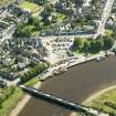
So much for the historical background, but in considering the existing structures it is unnecessary to go back further than about 1817, to which year J Robison dates the reconstruction of the harbour. Another record (1836) of what was presumably the same operation states that 'between 1822 and 1825 upwards of £1,620 had been expended on the excavation of the harbour, and erection of new piers'. By 1843 there existed a dock [NX65SE 81.01] having one side of wood and the other of stone, the parish minister (NSA) remarking that vessels would often unload at the beach and take on their cargo in the dock. He gives the depth of the water as varying between 30ft [9.1m] at springs and 25ft [7.6m] at neaps; a later estimate, of 1847, gives 7ft [2.1m] to 30ft [9.1m] according to the state of the tide, with 17ft [5.2m] at the quays at springs. The OS maps, beginning with a 6-inch edition of 1850, show the creek organised as a parallel-sided basin 145ft [44.2m] long on its W side, including a quay which projected 65ft [19.8m] forward of the shore-line, 290ft [88.4m] long on the E over a projecting L-shaped 'landingstage' [NX65SE 81.02], and 80ft [24.4m] wide. Its inner end was 170ft [51.8m] from the southern house-fronts of St Cuthbert Street, and its SE corner, which formed an acute angle, was 105ft [32m] from the opening of St Cuthbert's Place. Old photographs, perhaps of the 1890's or earlier, preserved in the Stewartry Museum, show the landing stage as a timber structure at the end of a stone quay, and numerous bollards. One photograph shows, close to the basin on the W, what appears to be the entrance to a shipbuilding yard just E of the Mote Brae; a yard is marked here on the large-scale OS town-plan of 1862, and Robison states that the easternmost part of the Brae was turned over, after extensive levelling, to industrial uses which included a ship-yard. He implies a date in the earlier 19th century. The whole area was made into a pleasure-ground in 1895.
The 19th-century harbour was reorganised in 1912, when the dock was filled in and the quay-wall was given its present form. Among the cast-iron bollards there are five of a peculiar form, being bean-shaped in horizontal section. The specimen examined measured 25ins [63.5cm] in width at ground level by 10ins [25.4cm] at the centre, while the top thickened and overhung the concavity. The convex side was turned away from the waterfront, and in some cases an iron bar, 1in [25mm] thick and curved to shape, had been bolted horizontally 9.5ins [241mm] below the shoulder, to prevent ropes slipping off. As one of them appears in a 19th-century photograph, they must have been old quay-fittings re-used after 1912.
[Sources and authorities cited].
A Graham and A E Truckell 1977.
(Location cited as NX 684 512). Kirkcudbright Harbour, quay built 1910, engineers J. & H. V. Eaglesham, Ayr. Granite-fronted quay with a small slipway at one end.
J R Hume 1976.
Kirkcudbright Harbour is an ill-defined area of the River Dee, which here forms the boundary between the parishes of Twynholm (to the N) and Kirkcudbright (to the S). The quay, wet dock and pier are all on the S bank of the river, as is the burgh itself (NX65SE 67).
Information from RCAHMS (RJCM), 10 July 2006.

