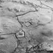
 |
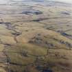
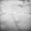
On-line Digital Images |
SC 1756285 |
RCAHMS Aerial Photography |
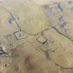
Oblique aerial view centred on the remains of rig with church, burial ground, homestead moat and building adjacent, taken from the NW. |
18/12/2002 |
Item Level |
|
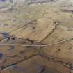 |
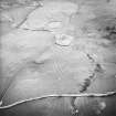
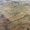
On-line Digital Images |
SC 1756287 |
RCAHMS Aerial Photography |
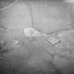
Oblique aerial view centred on the remains of rig with church, burial ground, homestead moat and building adjacent, taken from the SE. |
18/12/2002 |
Item Level |
|
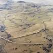 |
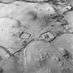
On-line Digital Images |
SC 1756288 |
RCAHMS Aerial Photography |
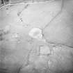
Oblique aerial view centred on the remains of rig with church, burial ground, homestead moat and building adjacent, taken from the ESE. |
18/12/2002 |
Item Level |
|
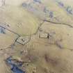 |
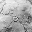
On-line Digital Images |
SC 1756291 |
RCAHMS Aerial Photography |
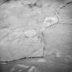
Oblique aerial view centred on the remains of the church, burial ground, homestead moat and building with rig adjacent, taken from the WNW. |
18/12/2002 |
Item Level |
|
 |
On-line Digital Images |
SC 1756292 |
RCAHMS Aerial Photography |
Oblique aerial view centred on the remains of the church, burial ground, homestead moat and building with rig adjacent, taken from the WSW. |
18/12/2002 |
Item Level |
|
 |
On-line Digital Images |
SC 1756293 |
RCAHMS Aerial Photography |
Oblique aerial view centred on the remains of the church, burial ground, homestead moat, building and enclosure with rig adjacent, taken from the WSW. |
26/3/2002 |
Item Level |
|
 |
On-line Digital Images |
SC 1756295 |
RCAHMS Aerial Photography |
Oblique aerial view centred on the remains of the church, burial ground, homestead moat, building and enclosure with rig adjacent, taken from the SSW. |
26/3/2002 |
Item Level |
|
 |
On-line Digital Images |
SC 1756298 |
RCAHMS Aerial Photography |
Oblique aerial view centred on the remains of the church, burial ground, homestead moat, building and enclosure with rig adjacent, taken from the SE. |
26/3/2002 |
Item Level |
|
 |
On-line Digital Images |
SC 1756299 |
RCAHMS Aerial Photography |
Oblique aerial view centred on the remains of the church, burial ground, homestead moat, building and enclosure with rig adjacent, taken from the ENE. |
26/3/2002 |
Item Level |
|
 |
On-line Digital Images |
SC 1756302 |
RCAHMS Aerial Photography |
Oblique aerial view centred on the remains of the church, burial ground, homestead moat, building and enclosure with rig adjacent, taken from the NNW. |
26/3/2002 |
Item Level |
|
 |
On-line Digital Images |
SC 1756351 |
RCAHMS Aerial Photography |
Oblique aerial view centred on the remains of the church, burial ground, homestead moat and building with rig adjacent, taken from the E. |
18/12/2002 |
Item Level |
|
 |
On-line Digital Images |
SC 1756352 |
RCAHMS Aerial Photography |
Oblique aerial view centred on the remains of the church, burial ground, homestead moat and building with rig adjacent, taken from the NNW. |
18/12/2002 |
Item Level |
|
 |
On-line Digital Images |
SC 1756353 |
RCAHMS Aerial Photography |
Oblique aerial view centred on the remains of the church, burial ground, homestead moat and building with rig adjacent, taken from the NNW. |
18/12/2002 |
Item Level |
|
 |
On-line Digital Images |
SC 1756492 |
RCAHMS Aerial Photography |
Oblique aerial view centred on the remains of rig with church, burial ground, homestead moat and building adjacent, taken from the ESE. |
18/12/2002 |
Item Level |
|
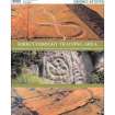 |
Digital Files (Non-image) |
WP 007324 |
Records of the Royal Commission on the Ancient and Historical Monuments of Scotland (RCAHMS), Edinbu |
RCAHMS Archaeological Survey - Kirkcudbright Training Area - Survey Report |
19/9/2003 |
Item Level |
|
|
Digital Files (Non-image) |
TM 000558 |
Records of the Royal Commission on the Ancient and Historical Monuments of Scotland (RCAHMS), Edinbu |
RCAHMS Archaeological Survey - Kirkcudbright Training Area - Survey Linework |
5/6/2003 |
Item Level |
|
 |
On-line Digital Images |
SC 2465340 |
Records of the Ordnance Survey, Southampton, Hampshire, England |
Dunrod, NX64NE 7, Ordnance Survey index card, Recto |
1958 |
Item Level |
|
 |
On-line Digital Images |
SC 2465341 |
Records of the Ordnance Survey, Southampton, Hampshire, England |
Dunrod, NX64NE 7, Ordnance Survey index card, page number 1, Recto |
1958 |
Item Level |
|
 |
On-line Digital Images |
SC 2465342 |
Records of the Ordnance Survey, Southampton, Hampshire, England |
Dunrod, NX64NE 7, Ordnance Survey index card, page number 2, Verso |
1958 |
Item Level |
|
|
All Other |
551 166/1/1 |
Records of the Ordnance Survey, Southampton, Hampshire, England |
Archaeological site card index ('495' cards) |
1947 |
Sub-Group Level |
|
|
All Other |
551 227/37 |
Records of SUAT Ltd, archaeologists, Perth, Perth and Kinross, Scotland |
Archives from a survey of medieval moated sites in Scotland |
1996 |
Group Level |
|


