|
Prints and Drawings |
DC 11120 |
|
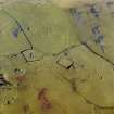
Comparative plans of moated sites, RCAHMS? |
|
Item Level |
|
|
Photographs and Off-line Digital Images |
E 4779 |
|
Photographic copy of comparative plans of moated sites, RCAHMS? |
|
Item Level |
|
|
Manuscripts |
MS 731/23 |
Records of the Royal Commission on the Ancient and Historical Monuments of Scotland (RCAHMS), Edinbu |
RCAHMS archaeological field survey database: Krikcudbright Training Area, August 2002. Held as an attribute table in GIS. Please see DX001447 |
8/2002 |
Item Level |
|
 |
On-line Digital Images |
SC 856643 |
RCAHMS Aerial Photography |
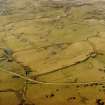
Oblique aerial view centred on the remains of the church, burial ground, homestead moat and building with rig adjacent, taken from the WSW. |
18/12/2002 |
Item Level |
|
 |
On-line Digital Images |
SC 911944 |
RCAHMS Aerial Photography |
Oblique aerial view centred on the remains of rig with church, burial ground, homestead moat and building adjacent, taken from the ESE. |
18/12/2002 |
Item Level |
|
|
Photographs and Off-line Digital Images |
E 12623 CN |
RCAHMS Aerial Photography |
Oblique aerial view centred on the remains of rig with church, burial ground, homestead moat and building adjacent, taken from the ESE. |
18/12/2002 |
Item Level |
|
|
Photographs and Off-line Digital Images |
E 13865 |
RCAHMS Aerial Photography |
Oblique aerial view centred on the remains of the church, burial ground, homestead moat, building and enclosure with rig adjacent, taken from the WSW. |
26/3/2002 |
Item Level |
|
|
Photographs and Off-line Digital Images |
E 13867 |
RCAHMS Aerial Photography |
Oblique aerial view centred on the remains of the church, burial ground, homestead moat, building and enclosure with rig adjacent, taken from the SSW. |
26/3/2002 |
Item Level |
|
|
Photographs and Off-line Digital Images |
E 13870 |
RCAHMS Aerial Photography |
Oblique aerial view centred on the remains of the church, burial ground, homestead moat, building and enclosure with rig adjacent, taken from the SE. |
26/3/2002 |
Item Level |
|
|
Photographs and Off-line Digital Images |
E 13871 |
RCAHMS Aerial Photography |
Oblique aerial view centred on the remains of the church, burial ground, homestead moat, building and enclosure with rig adjacent, taken from the ENE. |
26/3/2002 |
Item Level |
|
|
Photographs and Off-line Digital Images |
E 13874 |
RCAHMS Aerial Photography |
Oblique aerial view centred on the remains of the church, burial ground, homestead moat, building and enclosure with rig adjacent, taken from the NNW. |
26/3/2002 |
Item Level |
|
|
Photographs and Off-line Digital Images |
E 12620 CN |
RCAHMS Aerial Photography |
Oblique aerial view centred on the remains of rig with church, burial ground, homestead moat and building adjacent, taken from the NW. |
18/12/2002 |
Item Level |
|
|
Photographs and Off-line Digital Images |
E 12622 CN |
RCAHMS Aerial Photography |
Oblique aerial view centred on the remains of rig with church, burial ground, homestead moat and building adjacent, taken from the SE. |
18/12/2002 |
Item Level |
|
|
Photographs and Off-line Digital Images |
E 12624 CN |
RCAHMS Aerial Photography |
Oblique aerial view centred on the remains of rig with church, burial ground, homestead moat and building adjacent, taken from the ESE. |
18/12/2002 |
Item Level |
|
|
Photographs and Off-line Digital Images |
E 23510 |
RCAHMS Aerial Photography |
Oblique aerial view centred on the remains of the church, burial ground, homestead moat and building with rig adjacent, taken from the E. |
18/12/2002 |
Item Level |
|
|
Photographs and Off-line Digital Images |
E 23511 |
RCAHMS Aerial Photography |
Oblique aerial view centred on the remains of the church, burial ground, homestead moat and building with rig adjacent, taken from the NNW. |
18/12/2002 |
Item Level |
|
|
Photographs and Off-line Digital Images |
E 23512 |
RCAHMS Aerial Photography |
Oblique aerial view centred on the remains of the church, burial ground, homestead moat and building with rig adjacent, taken from the NNW. |
18/12/2002 |
Item Level |
|
|
Photographs and Off-line Digital Images |
E 12627 CN |
RCAHMS Aerial Photography |
Oblique aerial view centred on the remains of the church, burial ground, homestead moat and building with rig adjacent, taken from the WNW. |
18/12/2002 |
Item Level |
|
|
Photographs and Off-line Digital Images |
E 12628 CN |
RCAHMS Aerial Photography |
Oblique aerial view centred on the remains of the church, burial ground, homestead moat and building with rig adjacent, taken from the WSW. |
18/12/2002 |
Item Level |
|
 |
On-line Digital Images |
DP 000022 |
Records of the Royal Commission on the Ancient and Historical Monuments of Scotland (RCAHMS), Edinbu |
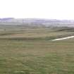
View of homestead moat from N |
2003 |
Item Level |
|
 |
On-line Digital Images |
DP 000023 |
Records of the Royal Commission on the Ancient and Historical Monuments of Scotland (RCAHMS), Edinbu |
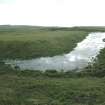
View of water filled ditch at SW corner of moat |
2003 |
Item Level |
|
|
Manuscripts |
MS 36/173 |
Records of the Royal Commission on the Ancient and Historical Monuments of Scotland (RCAHMS), Edinbu |
Field notebook of K A Steer (RCAHMS). 'S6 - Kirkcudbright, Wigtown'. |
17/5/1951 |
Item Level |
|
 |
Digital Files (Non-image) |
WP 000778 |
Records of the Royal Commission on the Ancient and Historical Monuments of Scotland (RCAHMS), Edinbu |
Scanned copy of RCAHMS Marginal Land Survey unpublished typescripts (Kircudbrightshire). |
1951 |
Item Level |
|
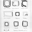 |
On-line Digital Images |
SC 1392212 |
|
Photographic copy of comparative typologies. Filed under NT50NE 3. |
|
Item Level |
|


