
Dunrod


Moated Site (Medieval)
Site Name Dunrod
Classification Moated Site (Medieval)
Canmore ID 63927
Site Number NX64NE 7
NGR NX 6997 4591
Datum OSGB36 - NGR
Permalink http://canmore.org.uk/site/63927


- Council Dumfries And Galloway
- Parish Kirkcudbright
- Former Region Dumfries And Galloway
- Former District Stewartry
- Former County Kirkcudbrightshire
NX64NE 7 6997 4591.
(NX 6997 4591) Ancient Earthwork (NAT)
OS 6" map (1957)
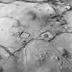
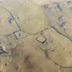
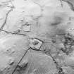
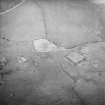
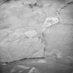
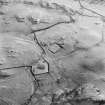
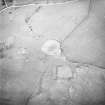
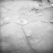
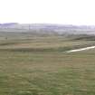
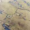
This homestead moat, partly excavated by Burdon Davies in 1964-5, consists of a rectangular platform measuring 120' N-S by 110' transversely surrounded by a 20' wide moat. The inner edge is fairly well-defined, except for the E side. The surface of the platform shows traces of a bulding in the NE quarter. There is a spill-way at the SW corner.
The pottery found was mainly 13th century with occupation of less than 100 years. A few fragments of 15th or 16th century pottery were also found, suggesting a possible re-occupation of the site, improvements being made at that time in controlling the level of the water in the moat. (See also Dunrod Village NX64NE 9, and church NX64NE 8).
E F B Davies 1966
This moat is as described.
Surveyed at 1/2500.
Visited by OS (DWR) 7 April 1971
This site is listed in an Atlas of Scottish History (McNeill and MacQueen 1996) as a moated site.
Information from RCAHMS (DE) September 1997.
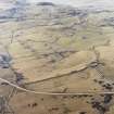
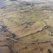
This homestead moat is situated on a relatively low lying terrace bounded by rising ground to the N, E and S, and lies to the S of Dunrod Church (NX64NE 8) and to the W of a small unnamed burn. The homestead moat comprises a rectangular platform bounded by a fragmentary stony bank, probably the remains of a robbed wall, and a substantial ditch. The interior platform measures 37.9m by 34m transversely from NNE to SSW, within the bank, and is marked by a series of amorphous mounds, perhaps from unrecorded excavations, and probably cultivation and small scale quarrying. The surrounding moat is large and on the SW it is rock cut, measuring 8m in width and up to 1.8m in depth. The moat shallows to the NE corner, where there is a dip in the outer edge of the ditch where it is closest to the burn, possibly marking the source of water for the moat. A second dip in the line of the outer edge of the moat in the SW corner leads into a shallow drain, perhaps providing an overflow feeding into a channel that extends to the S where it may have rejoined the unnamed burn.
(KTA02 252)
Visited by RCAHMS (AGCH, DCC) 25 November 2002.
Field Visit (1 October 1952)
NX 699 459 Homestead Moat, Dunrod.
This is an excellent example of a homestead moat, similar to the one at Queen’s Hill. Note that there is a chapel site in the immediate vicinity.
Visited by RCAHMS (KAS) 1 October 1952.
OS map ref: lv SW ‘Roman Camp’
Field Visit (1996 - 2003)
Russell Coleman managed an Historic Scotland funded project to record medieval moated sites in Scotland. Gazetteers were produced for each regional council area between 1996 and 2002 with an uncompleted overall review in 2002-03. The results of the first year of the project were published in Tayside and Fife Archaeological Journal, Volume 3 (1997).

