
Following the launch of trove.scot in February 2025 we are now planning the retiral of some of our webservices. Canmore will be switched off on 24th June 2025. Information about the closure can be found on the HES website: Retiral of HES web services | Historic Environment Scotland
Poulouriscaig


Township (Period Unassigned)
Site Name Poulouriscaig
Classification Township (Period Unassigned)
Canmore ID 6370
Site Number NC76NE 7
NGR NC 765 656
Datum OSGB36 - NGR
Permalink http://canmore.org.uk/site/6370


- Council Highland
- Parish Farr
- Former Region Highland
- Former District Sutherland
- Former County Sutherland
NC76NE 7 765 656.
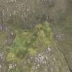
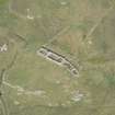
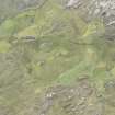
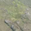
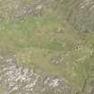
Poulouriscaig is a township settled by people cleared from Strathnaver in 1814-9 and deserted about 1943. It comprises the roofless remains of seven buildings, kaleyards and enclosures, and areas of lazy-beds, all within an enclosing boundary wall. Most of the houses appear to date from the late 19th century.
Visited by OS 15 July 1977.
The township comprising six roofed buildings and one unroofed building is depicted on the 1st edition of the OS 6-inch map (Sutherland 1878, sheet ix). There are seven unroofed buildings shown on the current edition of the OS 1:10,560 map (1962).
Information from RCAHMS (AKK) 14 August 1995.

