|
Manuscripts |
MS 121/24 |
Papers of Roger J Mercer, archaeologist, Edinburgh, Scotland |
Sutherland Survey R.J.Mercer 1980 (SUT 62) |
1980 |
Item Level |
|
 |
On-line Digital Images |
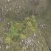
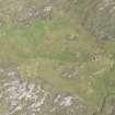
DP 092993 |
RCAHMS Aerial Photography Digital |
Oblique aerial view of the remains of the township of Poulouriscaig, taken from the NNW. |
23/7/2010 |
Item Level |
|
 |
On-line Digital Images |
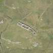
DP 160112 |
RCAHMS Aerial Photography Digital |
Oblique aerial view of Poulouriscaig township and farmstead, looking to the NE. |
19/7/2013 |
Item Level |
|
 |
On-line Digital Images |
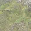
DP 160335 |
RCAHMS Aerial Photography Digital |
Oblique aerial view of Poulouriscaig, looking to the SSW. |
19/7/2013 |
Item Level |
|
 |
On-line Digital Images |
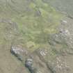
DP 160337 |
RCAHMS Aerial Photography Digital |
Oblique aerial view of Poulouriscaig, looking to the SE. |
19/7/2013 |
Item Level |
|
 |
On-line Digital Images |
DP 160338 |
RCAHMS Aerial Photography Digital |
Oblique aerial view of Poulouriscaig, looking to the SE. |
19/7/2013 |
Item Level |
|
 |
On-line Digital Images |
SC 2349287 |
Records of the Ordnance Survey, Southampton, Hampshire, England |
Poulouriscaig, NC76NE 7, Ordnance Survey index card, Recto |
1958 |
Item Level |
|
 |
On-line Digital Images |
SC 2349288 |
Records of the Ordnance Survey, Southampton, Hampshire, England |
Poulouriscaig, NC76NE 7, Ordnance Survey index card, Recto |
1958 |
Item Level |
|
|
All Other |
551 166/1/1 |
Records of the Ordnance Survey, Southampton, Hampshire, England |
Archaeological site card index ('495' cards) |
1947 |
Sub-Group Level |
|


