
Dinnans


Promontory Fort (Period Unassigned)
Site Name Dinnans
Classification Promontory Fort (Period Unassigned)
Alternative Name(s) 'Old Fort'
Canmore ID 63253
Site Number NX44SE 3
NGR NX 47860 40260
Datum OSGB36 - NGR
Permalink http://canmore.org.uk/site/63253


- Council Dumfries And Galloway
- Parish Whithorn
- Former Region Dumfries And Galloway
- Former District Wigtown
- Former County Wigtownshire
NX44SE 3 47860 40260
(NX 4786 4026) Promontory Fort (NR)
OS 6" map (1957)
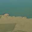
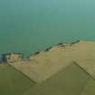
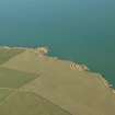
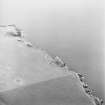
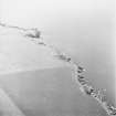
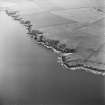
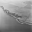
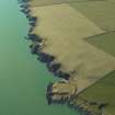
"The Old Fort", Promontory Fort, Dinnans: A large part of this fort, which occupies a promontory 70' - 80' above the sea, has been eroded away. The landward side is defended by two massive earth and stone ramparts, 32' and 38' broad at base, with two wide, deep external ditches, 43' and 32' wide crest to crest. The entrance is c 30' from the N edge of the ravine which forms the S side of the promontory. In 1911 (RCAHMS 1912, visited 1911) the RCAHMS suggested that on the N side of the entrance, where the inner rampart has been dug out for 22', and another hollow behind it, may have been hut sites, though in 1955 they consider that the first may have been dug out for a house stance, though there are no foundations to prove it, while the second is even more doubtful.
The slight innermost bank on the cliff-edge at the S end of the fort has a weapon-pit in it, and may be only a war-time breastwork. The structure in the interior is an observation post, also built in the 1939-45 war. The terraces on the grassy ridge to seaward, which were thought probably artificial in 1911, were considered natural in 1955.
RCAHMS TS., visited 1955
Generally as described. The area enclosed by the bivallate defences measures 42.0m N-S by 41.0m E-W. The scoop in the inner rampart to the N of the entrance is probably the result of robbing. Behind this rampart are three possible timber house platforms, levelled into the slope.
Resurveyed at 1:2500.
Visited by OS (DWR) 26 January 1973
Field Visit (12 October 1955)
This site was included within the RCAHMS Marginal Land Survey (1950-1962), an unpublished rescue project. Site descriptions, organised by county, are available to view online - see the searchable PDF in 'Digital Items'. These vary from short notes, to lengthy and full descriptions. Contemporary plane-table surveys and inked drawings, where available, can be viewed online in most cases - see 'Digital Images'. The original typecripts, notebooks and drawings can also be viewed in the RCAHMS search room.
Information from RCAHMS (GFG) 19 July 2013.
Note (20 December 2013 - 9 August 2016)
This fort occupies a heavily eroded promontory on the E coast of the Machars, Its defences comprise two massive ramparts with external ditches, which are drawn in an arc across the neck of the promontory with their ends resting on the cliff-edges well beyond the margins of the promontory itself. The inner rampart is some 9.5m in thickness and the outer 11m, standing 2.5m and 3.5m above the bottoms of their corresponding ditches, which are 9m and 6m in breadth respectively. A gap in the centre of the defences probably marks the position of the original entrance, though it has been disturbed by the use of the interior as a cattle feeding stance reported in 1996. The interior measures a maximum of 46m from NW to SE by 35m transversely (0.15ha), but has evidently been much bigger, with large areas eroded on the NE and SW, and no doubt some reduction of is SE, seaward, face too. The OS reported three possible house platforms to the rear of the rampart, but it is unlikely that any trace of these will have survived the poaching caused by cattle feeding. The only other features visible within the interior are a WW II observation post, and what may have been a contemporary breastwork and weapon pit on the S margin of the promontory.
Information from An Atlas of Hillforts of Great Britain and Ireland – 09 August 2016. Atlas of Hillforts SC0235

